OSi Annual Report 2006 English Version - Ordnance Survey Ireland
OSi Annual Report 2006 English Version - Ordnance Survey Ireland
OSi Annual Report 2006 English Version - Ordnance Survey Ireland

You also want an ePaper? Increase the reach of your titles
YUMPU automatically turns print PDFs into web optimized ePapers that Google loves.
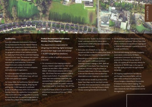
Limerick City<br />
GeoDirectory<br />
Product Development & Publications<br />
• The success of the “Dublin City and District Street<br />
• The Royal Irish Academy (RIA) production of its<br />
From the collaborative involvement of <strong>Ordnance</strong><br />
<strong>Survey</strong> <strong>Ireland</strong> and An Post, this National Address<br />
Database was created and is maintained jointly by<br />
<strong>OSi</strong> and An Post. <strong>OSi</strong> is responsible for maintaining<br />
the geographic element of each address and also<br />
for supplying An Post with the customised mapping<br />
Division (Tourist Mapping)<br />
This department is responsible for<br />
designing and deriving digital and paper<br />
products from large-scale and national<br />
1:10,000 topographical databases.<br />
Guide” continued and the 6th Edition which<br />
was launched in <strong>2006</strong> further demonstrated the<br />
popularity of this product.<br />
• Every year, two of <strong>Ireland</strong>’s six city maps are<br />
revised and <strong>2006</strong> saw the 3rd edition of the Street<br />
Maps of Galway and Waterford being published.<br />
annual and much acclaimed “Historic Town Atlas”<br />
relies on <strong>Ordnance</strong> <strong>Survey</strong> <strong>Ireland</strong>’s mapping and<br />
in <strong>2006</strong> the RIA publication covered the towns of<br />
Dundalk and Kilkenny.<br />
• The Junior and Leaving Certificates Geography<br />
examinations conducted by the State’s<br />
required for their input. The database now contains<br />
1.8 million standardised addresses and is used<br />
extensively by Local Authorities, Government<br />
Departments and a variety of commercial<br />
organisations such as banks, insurance companies<br />
and market research organisations.<br />
<strong>2006</strong> saw a number of significant achievements<br />
in this area:<br />
• For convenience in the mapping production<br />
process, <strong>Ireland</strong> is segmented into “Tiles” which<br />
equate to an area 20km x 20km square i.e.<br />
400km 2 . While <strong>Ireland</strong> comprises 252 of these<br />
• Responding to a clear customer demand evident<br />
from a pilot launch in 2004 and confirmed<br />
following a product redesign in 2005, <strong>2006</strong> saw<br />
an additional 70 new Raster Town Maps being<br />
produced. Customers using this product as<br />
diverse as Fáilte Eireann to the many companies<br />
Examination Commission rely on mapping<br />
produced by <strong>Ordnance</strong> <strong>Survey</strong> <strong>Ireland</strong>. In<br />
<strong>2006</strong>, <strong>OSi</strong> supplied all the necessary data for the<br />
production of 190,000 maps, to the required<br />
very high quality and within the rigid timelines<br />
demanded.<br />
The normal generation of postal routes by <strong>OSi</strong> for<br />
tiles, 103 of these Tiles were updated in <strong>2006</strong> as<br />
in the services industries where localised but<br />
• <strong>OSi</strong> mapping supported both the Killarney<br />
An Post continued in <strong>2006</strong> without issue, with over<br />
a direct result of which, 14 updated Discovery<br />
dependable accurate mapping is a requirement.<br />
and Donegal International Rallies, with not<br />
3,500 routes plotted and supplied.<br />
For Census <strong>2006</strong>, the GeoDirectory Team produced<br />
the required customised mapping, designing and<br />
plotting over 12,000 maps which contributed<br />
greatly to the effectiveness of the CSO enumerators.<br />
Post the Census, <strong>OSi</strong> supplied the Central Statistics<br />
Series maps were published. Importantly, the<br />
associated Raster Images generated a separate<br />
but increasingly popular new product within the<br />
Digital Sales outlet for these Raster “20 x 20” Tiles.<br />
• A new Rural Raster product for use in the web<br />
environment was produced from our 1:10000<br />
• An unplanned but valuable by product of the<br />
Raster Town Maps was the new North Leinster<br />
Town Atlas which was launched as a pilot product<br />
during the year and covering 30 towns in North<br />
Leinster stretching from Kilcock to Dundalk.<br />
alone visitors to these events but also the<br />
drivers/navigators depending on the accuracy<br />
of <strong>Ordnance</strong> <strong>Survey</strong> <strong>Ireland</strong> mapping. The<br />
“<strong>Ordnance</strong> <strong>Survey</strong> <strong>Ireland</strong>” Killarney Rally of the<br />
Lakes remains the main <strong>OSi</strong> sponsored event for<br />
the organisation.<br />
Office (CSO) with a range of digital files on a county<br />
dataset.<br />
by county basis with the required polygonisation to<br />
facilitate their analysis of the information obtained.