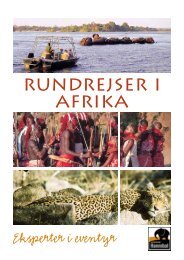
Version: 2012 Tour Code: IZL It has the country’s biggest concentration of hippopotamuses and crocodiles and large dry season mammal populations of elephant and buffalo. Lake Kariba Having cascaded over the Victoria Falls, and tumbled and swirled through the Batoka gorges, the old Zambezi River then flowed gently across a flat valley floor to the Kariba gorge. This was the home of the BaTonka people who believed there was a god of the river – Nyaminyami. Enter technological man and his desire to put a dam wall across the Kariba gorge to harness the river’s flow to generate hydroelectric power. The dream became a fact in December 1958, and the man-made Lake Kariba began to fill, and reached its capacity four years later. In the meantime, about 57 000 tribes people had to be resettled, and “Operation Noah” led by Rupert Fothergill, had rescued and translocated 5000 animals. Kariba dam wall has a height of 128 m and produces a lake of 5200 km² in area at full capacity. Then the water surface is at an altitude of 484 m above sea level. On the <strong>Zimbabwe</strong>an side, the water became the Lake Kariba Recreational Park, with an area of 2830 km². During its life so far, the lake has had its share of ecological incidents, and three should be mentioned. In its early eutrophic days, the lake witnessed an invasion of a water fern (Salvinia molesta), named the Kariba weed, but over the ensuing years the weed has greatly declined. In the 1960s several introductions of the Lake Tanganyika sardine (Limnothrissa miodon) were made, and eventually the ‘kapenta’ fishery has developed to great productivity. Finally, being a ‘sink’, the lake has accumulated pesticides and pollution from agriculture and tsetse fly control in its catchment. Fortunately, surveys have shown that the early dire predictions, for example, of Fish Eagles going extinct, have not been realised. Kariba town is one of the hottest places in <strong>Zimbabwe</strong>, with temperatures sometimes exceeding 40ºC. The average rainfall along the lake is 650-700 mm, occurring mainly in November to March. The main habitats are mopane woodland and grassland in the shore, with shelving or rocky slopes. There are many islands (previously hill-tops) in the lake. The Zambezi water is rather clean and poor in nutrients, having filtered through Barotseland in Zambia, which puts a severe limit on the numbers of water birds that can be accommodated. Nevertheless along the shore one seems never to be out of earshot of a vociferous Fish Eagle, and this bird can surely serve as the emblem for the lake. Chizarira National Park Chizarira is perhaps the most scenic park in <strong>Zimbabwe</strong>. The remoteness of the area is aptly captured by the name “Chizarira”, which is a Shona word meaning “cage trap”. Closed off by name and nature, Chizarira's high escarpment views, green gorges, natural springs, dense woodlands and floodplains are remote and infrequently visited. Most of the Park is an undulating plateau set on the Zambezi Escarpment overlooking Lake Kariba. From here the Park extends southwards to the low-lying Busi region. The banks of the Busi River strongly resemble the river frontage of Mana Pools National Park. Acacia Albida trees attract many herbivores, in particular elephants, to the riverbank. This used to be big five country, but the black rhino were relocated in order to protect and monitor their diminishing numbers. Good populations of elephant, buffalo, lion and leopard can still be found in the Park. Other game includes cheetah, zebra and a range of antelope including sable, common waterbuck, kudu, bushbuck, klipspringer and steenbok. With its grassy valleys and riverine forests Chizarira is also a birders paradise. The game is widely distributed throughout the Park and viewing can be difficult due to the tall grass. The appeal of Chizarira lies instead in its total remoteness and the opportunity to experience Africa in its original form.
Version: 2012 Tour Code: IZL The Park is known for its excellent game walking and the best way to enjoy the flora and fauna is to walk along the elephant tracks and mountain trails with a professional guide. Although it is open year round, the rainy season renders some areas inaccessible, and the best time to visit is June to September.