Leica Cyclone SURVEY 7.0 Comprehensive Software for ...
Leica Cyclone SURVEY 7.0 Comprehensive Software for ...
Leica Cyclone SURVEY 7.0 Comprehensive Software for ...

Create successful ePaper yourself
Turn your PDF publications into a flip-book with our unique Google optimized e-Paper software.
<strong>Leica</strong> <strong>Cyclone</strong> <strong>SURVEY</strong> <strong>7.0</strong><br />
Efficient Point Cloud Manipulation & Navigation<br />
<strong>Leica</strong> <strong>Cyclone</strong> <strong>SURVEY</strong> has many features that let users work efficiently with rich<br />
laser scan data sets. <strong>Cyclone</strong>'s Level of Detail (LOD) graphics display and<br />
visualization modes allow users to “see through” walls, apply shaded rendering,<br />
or enhance edges <strong>for</strong> improved comprehension of dense point clouds. Texture<br />
mapping tools allow users to accurately “drape” photos of the scanned scene<br />
onto point clouds <strong>for</strong> an even more realistic viewing experience. <strong>Cyclone</strong><br />
<strong>SURVEY</strong>’s friendly key plan and TruSpace panoramic viewing modes provide<br />
intuitive navigation and viewing options.<br />
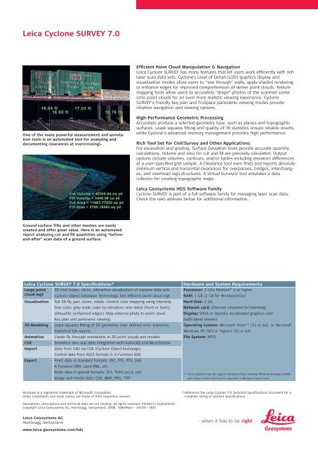
One of the many powerful measurement and annotation<br />
tools is an automated tool <strong>for</strong> analyzing and<br />
documenting clearances at overcrossings.<br />
High-Per<strong>for</strong>mance Geometric Processing<br />
Accurately produce a selected geometry type, such as planes and topographic<br />
surfaces. Least-squares fitting and quality-of-fit statistics ensure reliable results,<br />
while <strong>Cyclone</strong>’s advanced memory management provides high per<strong>for</strong>mance.<br />
Rich Tool Set <strong>for</strong> Civil/Survey and Other Applications<br />
For excavation and grading, Surface Deviation tools provide accurate quantity<br />
calculations. Volume and area <strong>for</strong> cut and fill are precisely calculated. Output<br />
options include volumes, contours, and/or tables including elevation differences<br />
at a user-specified grid sample. A Clearance tool even finds and reports absolute<br />
minimum vertical and horizontal clearances <strong>for</strong> overpasses, bridges, interchanges,<br />
and overhead sign structures. A Virtual Surveyor tool emulates a data<br />
collector <strong>for</strong> creating topographic maps.<br />
<strong>Leica</strong> Geosystems HDS <strong>Software</strong> Family<br />
<strong>Cyclone</strong> <strong>SURVEY</strong> is part of a full software family <strong>for</strong> managing laser scan data.<br />
Check the web address below <strong>for</strong> additional in<strong>for</strong>mation.<br />
Ground surface TINs and other meshes are easily<br />
created and offer great value. Here is an automated<br />
report analyzing cut and fill quantities using “be<strong>for</strong>eand-after”<br />
scan data of a ground surface.<br />
<strong>Leica</strong> <strong>Cyclone</strong> <strong>SURVEY</strong> <strong>7.0</strong> Specifications*<br />
Large point 3D limit boxes, slices, interactive visualization of massive data sets<br />
cloud mgt <strong>Cyclone</strong> Object Database Technology: fast efficient point cloud mgt.<br />
Visualization Full 3D fly, pan, zoom, rotate. Control color mapping using intensity,<br />
true-color, gray scale, color by elevation, one-sided (front or back),<br />
silhouette (enhanced edges). Map external photo to point cloud.<br />
Key plan and panoramic viewing.<br />
3D Modeling Least-squares fitting of 3D geometry. User defined error tolerance.<br />
Statistical QA reports<br />
Animation Create fly-through animations in 3D point clouds and models<br />
COE<br />
Seamless two-way data integration with AutoCAD and MicroStation<br />
Import Data from CAD via COE (<strong>Cyclone</strong> Object Exchange)<br />
Control data from ASCII <strong>for</strong>mats & X-Function DBX<br />
Export Point data in standard <strong>for</strong>mats: XYZ, PTS, PTX, DXF,<br />
X-Function DBX, Land XML, etc.<br />
Point data in special <strong>for</strong>mats: ZFS, TOPO pci & cwf<br />
Image and model data: COE, BMP, JPEG, TIFF<br />
Hardware and System Requirements<br />
Processor: 2 GHz Pentium ® 4 or higher<br />
RAM: 1 GB (2 GB <strong>for</strong> WindowsVista)<br />
Hard Disk: 2 GB<br />
Network card: Ethernet (required <strong>for</strong> licensing)<br />
Display: SVGA or OpenGL accelerated graphics card<br />
(with latest drivers)<br />
Operating system: Microsoft Vista** (32 or 64), or Microsoft<br />
Windows XP (SP2 or higher) (32 or 64)<br />
File System: NTFS<br />
** Some systems may not support Windows Vista‘s Desktop Windows Manager (DWM)<br />
with <strong>Leica</strong> <strong>Cyclone</strong> and must be operated in Windows Classic Look.<br />
Windows is a registered trademark of Microsoft Corporation.<br />
Other trademarks and trade names are those of their respective owners.<br />
* Reference the <strong>Leica</strong> <strong>Cyclone</strong> <strong>7.0</strong> Technical Specifications document <strong>for</strong> a<br />
complete listing of product specifications.<br />
Illustrations, descriptions and technical data are not binding. All rights reserved. Printed in Switzerland –<br />
Copyright <strong>Leica</strong> Geosystems AG, Heerbrugg, Switzerland, 2008. 768496en – VIII.09 – RDV<br />
<strong>Leica</strong> Geosystems AG<br />
Heerbrugg, Switzerland<br />
www.leica-geosystems.com/hds