Gliding 1950 - Lakes Gliding Club
Gliding 1950 - Lakes Gliding Club
Gliding 1950 - Lakes Gliding Club

You also want an ePaper? Increase the reach of your titles
YUMPU automatically turns print PDFs into web optimized ePapers that Google loves.
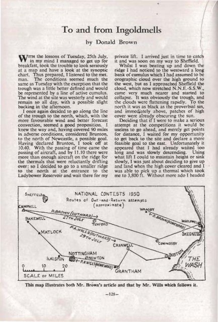
To and from Ingoldmells<br />
by Donald Brown<br />
ITH the lessons of Tuesday, 25th July,<br />
W in my mind I managed to get up for<br />
breakfast, took the trouble to look seriously<br />
at a map and have a look at the synoptic<br />
chart. Thus prepared, I listened to the met.<br />
man. The conditions seemed much the<br />
same as Tuesday with the exception that the<br />
trough was a little better defined and would<br />
be represented by a line of active cumulus.<br />
The wind at the site was westerly and would<br />
remain so all day, with a possible slight<br />
backing in the afternoon.<br />
I once again decided to go along the line<br />
of the trough to the north, which, with the<br />
more favourable wind and better forecast<br />
convection, seemed a good proposition. r<br />
knew the way and, having covered 90 miles<br />
in adverse conditions, considered Brunton,<br />
to the north of Newcastle, a possible goal.<br />
Having declared Brunton, I took off at<br />
10.40. With the passing of time came the<br />
passing of aircraft, and by 11.10 there were<br />
more than enough aircraft on the ridge for<br />
the thermals that were reluctantly drifting<br />
over; so I decided to go to a smaller ridge<br />
to the north at the entrance to the<br />
Ladybower Reservoir and wait there for my<br />
I<br />
private lift. I arrived just in time to catch<br />
it and was soon on my way to Sheffield. "<br />
Whilst I was beating up and down the<br />
ridge I had noticed 'to the westward a loog<br />
bank ofcumulus which I had assumed to be<br />
orographic cloud over the high ground to<br />
the west, but as I approached Sheffield the<br />
cloud, which now stretched N.N.E.-S.S.W.,<br />
came very much nearer and started to<br />
collapse. It was obviously the trough, and<br />
the clouds were flattening rapidly. To the<br />
north it was as black as the proverbial sin,<br />
and immed,iately above, patches of high<br />
cover were already obscuring the sun.<br />
Deciding that if I were to make a serious<br />
attempt at the competitions it would be<br />
useless to go ahead, and merely get points<br />
for diStance, I waited for my opportunity<br />
to get back to the site and declare a more<br />
feasible goal to the east. Unfortunately it<br />
appeared that I had already waited too<br />
long and was' slowly descending. Using<br />
what lift I could to maintain height or sink<br />
sloWly, I was just about deciding to give up<br />
and land when the high cover cleared and I<br />
was able to pick up a thermal which took<br />
me to 3,800 ft. Without more ado I headed<br />
o<br />
("tt'<br />
SCALE OF MILES<br />
This map illustrates both Mr. Brown's article and that by Mr. Wills which follows it.<br />
-128-