P-O Life - Anglophone-direct.com
P-O Life - Anglophone-direct.com
P-O Life - Anglophone-direct.com

Create successful ePaper yourself
Turn your PDF publications into a flip-book with our unique Google optimized e-Paper software.
Walktheregion...<br />
with Mike Rhodes<br />
Aplecs<br />
An ‘aplec’, Catalan for a gathering or mass<br />
meeting, traditionally used to involve a religious<br />
pilgrimage to a chapel or a hermitage, usually<br />
on a Saint’s day or religious festival when the<br />
heavens were likely to be at their most receptive!<br />
Today the term is also used for more popular<br />
get-togethers such as the meeting of dancers to<br />
perform the sardane.<br />
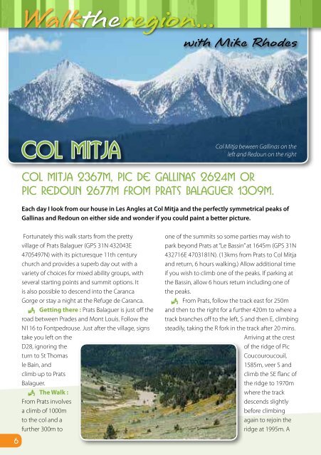
Col Mitja<br />
Col Mitja beween Gallinas on the<br />
left and Redoun on the right<br />
Col Mitja 2367m, Pic de Gallinas 2624m or<br />
Pic Redoun 2677m from Prats Balaguer 1309m.<br />
Each day I look from our house in Les Angles at Col Mitja and the perfectly symmetrical peaks of<br />
Gallinas and Redoun on either side and wonder if you could paint a better picture.<br />
Fortunately this walk starts from the pretty<br />
village of Prats Balaguer (GPS 31N 432043E<br />
4705497N) with its picturesque 11th century<br />
church and provides a superb day out with a<br />
variety of choices for mixed ability groups, with<br />
several starting points and summit options. It<br />
is also possible to descend into the Caranca<br />
Gorge or stay a night at the Refuge de Caranca.<br />
P Getting there : Prats Balaguer is just off the<br />
road between Prades and Mont Louis. Follow the<br />
N116 to Fontpedrouse. Just after the village, signs<br />
take you left on the<br />
D28, ignoring the<br />
turn to St Thomas<br />
le Bain, and<br />
climb up to Prats<br />
Balaguer.<br />
P The Walk :<br />
From Prats involves<br />
a climb of 1000m<br />
to the col and a<br />
further 300m to<br />
one of the summits so some parties may wish to<br />
park beyond Prats at “Le Bassin” at 1645m (GPS 31N<br />
432716E 4703181N). (13kms from Prats to Col Mitja<br />
and return, 6 hours walking.) Allow additional time<br />
if you wish to climb one of the peaks. If parking at<br />
the Bassin, allow 6 hours return including one of<br />
the peaks.<br />
P From Prats, follow the track east for 250m<br />
and then to the right for a further 420m to where a<br />
track branches off to the left, S and then E, climbing<br />
steadily, taking the R fork in the track after 20 mins.<br />
Arriving at the crest<br />
of the ridge of Pic<br />
Coucouroucouil,<br />
1585m, veer S and<br />
climb the SE flanc of<br />
the ridge to 1970m<br />
where the track<br />
descends slightly<br />
before climbing<br />
again to rejoin the<br />
ridge at 1995m. A<br />
further 5 mins sees us at the Collet d’Avall 1996m<br />
where we join the cross Pyrenees route GR10. After<br />
2 – 2 ½ hours of walking this col makes a great<br />
mid-morning stop with views over the Capcir and<br />
Tet valley.<br />
P From the collet it is possible to follow a wide<br />
track all the way to Col Mitja but our route now<br />
follows the well way marked GR10 route for another<br />
hour to the col, crossing the jeep track at various<br />
points. (3 – 3 ½ hours walking.)<br />
P From the col we are confronted with<br />
several options. Pic de Gallinas (GPS 31N 435492E<br />
4703167N) to the L and Redoun (GPS 31N 434664E<br />
4701733N) to the R are both just less than an hours<br />
walk but both offer the most fantastic views from<br />
the top. For those wanting to do a circuit via the<br />
Caranca Gorge, descend the other side of the pass<br />
on good tracks. Towards the bottom the path turns<br />
right to the refuge de Caranca 1831m where you<br />
may be able to get lunch or stay overnight. There<br />
is no phone at the refuge so making a reservation<br />
here involves a lot of pre-planning. Just before the<br />
refuge you will find the path on the L to Thues Entre<br />
Valls via the Caranca gorge taking 3 ½ hours.<br />
P Whichever route you chose, from the Col<br />
Mitja we are faced with more choices on the<br />
descent. It is possible to retrace our steps back<br />
to Prats or from Collet d’Avall, either continue<br />
descending the jeep track to the parking spot at<br />
Bassin or, just below the collet take the footpath<br />
The view south from the descent route. Pics are Pic<br />
Monellet 2727m (L) & Pic de Raco Petit 2785m (R).<br />
to the L through the forest following the GR10 to<br />
Bassin. Both routes take about 90 mins to Bassin.<br />
From the LH side of the Bassin pick up a good track<br />
that descends towards Prats. In 2 ½ km we join a<br />
jeep track by a ruined building “Le Castell” 1388m<br />
and Prats is now in view another 10 mins further on.<br />
Whichever route you have chosen you will<br />
have had a fantastic day out and will have seen<br />
opportunities for further walks in the valleys and<br />
peaks to the south towards the Spanish border.<br />
P On your drive down from Prats why not stop<br />
off at St Thomas le Bain for a dip in the hot pool or<br />
for a free dip, park at the first hairpin bend below<br />
Prats and take a track to the R where you will find<br />
a “source” which you may need to share with like<br />
minded people. L<br />
Mike Rhodes is an International Mountain Leader / Ac<strong>com</strong>panateur de Montagne,<br />
lives all year in Les Angles and specialises in guided walks in the high mountains and<br />
Snowshoe trips in winter. He can be contacted on +33 (0)4 68 04 37 28<br />
email: mike.rhodes@free.fr web site: www.pyrenean-trails.<strong>com</strong><br />
6 7