Tributary Tribune - California Conservation Corps
Tributary Tribune - California Conservation Corps
Tributary Tribune - California Conservation Corps

You also want an ePaper? Increase the reach of your titles
YUMPU automatically turns print PDFs into web optimized ePapers that Google loves.
Reconciling the past<br />
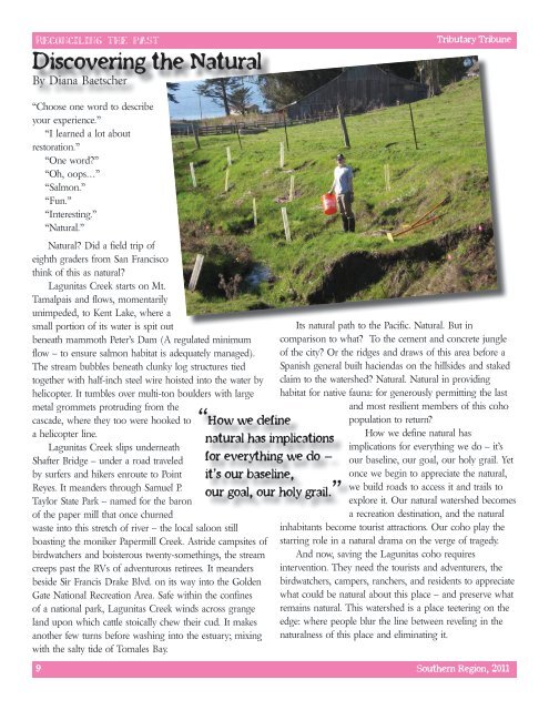
Discovering the Natural<br />
By Diana Baetscher<br />
<strong>Tributary</strong> <strong>Tribune</strong><br />
“Choose one word to describe<br />
your experience.”<br />
“I learned a lot about<br />
restoration.”<br />
“One word?”<br />
“Oh, oops…”<br />
“Salmon.”<br />
“Fun.”<br />
“Interesting.”<br />
“Natural.”<br />
Natural? Did a field trip of<br />
eighth graders from San Francisco<br />
think of this as natural?<br />
Lagunitas Creek starts on Mt.<br />
Tamalpais and flows, momentarily<br />
unimpeded, to Kent Lake, where a<br />
small portion of its water is spit out<br />
beneath mammoth Peter’s Dam (A regulated minimum<br />
flow – to ensure salmon habitat is adequately managed).<br />
The stream bubbles beneath clunky log structures tied<br />
together with half-inch steel wire hoisted into the water by<br />
helicopter. It tumbles over multi-ton boulders with large<br />
metal grommets protruding from the<br />
cascade, where they too were hooked to<br />
a helicopter line.<br />
Lagunitas Creek slips underneath<br />
Shafter Bridge – under a road traveled<br />
by surfers and hikers enroute to Point<br />
Reyes. It meanders through Samuel P.<br />
Taylor State Park – named for the baron<br />
of the paper mill that once churned<br />
waste into this stretch of river – the local saloon still<br />
boasting the moniker Papermill Creek. Astride campsites of<br />
birdwatchers and boisterous twenty-somethings, the stream<br />
creeps past the RVs of adventurous retirees. It meanders<br />
beside Sir Francis Drake Blvd. on its way into the Golden<br />
Gate National Recreation Area. Safe within the confines<br />
of a national park, Lagunitas Creek winds across grange<br />
land upon which cattle stoically chew their cud. It makes<br />
another few turns before washing into the estuary; mixing<br />
with the salty tide of Tomales Bay.<br />
“How we define<br />
natural has implications<br />
for everything we do –<br />
it’s our baseline,<br />
our goal, our holy grail.”<br />
Its natural path to the Pacific. Natural. But in<br />
comparison to what? To the cement and concrete jungle<br />
of the city? Or the ridges and draws of this area before a<br />
Spanish general built haciendas on the hillsides and staked<br />
claim to the watershed? Natural. Natural in providing<br />
habitat for native fauna: for generously permitting the last<br />
and most resilient members of this coho<br />
population to return?<br />
How we define natural has<br />
implications for everything we do – it’s<br />
our baseline, our goal, our holy grail. Yet<br />
once we begin to appreciate the natural,<br />
we build roads to access it and trails to<br />
explore it. Our natural watershed becomes<br />
a recreation destination, and the natural<br />
inhabitants become tourist attractions. Our coho play the<br />
starring role in a natural drama on the verge of tragedy.<br />
And now, saving the Lagunitas coho requires<br />
intervention. They need the tourists and adventurers, the<br />
birdwatchers, campers, ranchers, and residents to appreciate<br />
what could be natural about this place – and preserve what<br />
remains natural. This watershed is a place teetering on the<br />
edge: where people blur the line between reveling in the<br />
naturalness of this place and eliminating it.<br />
9 Southern Region, 2011