Military_Walk_Archae.. - Ashdown Forest
Military_Walk_Archae.. - Ashdown Forest
Military_Walk_Archae.. - Ashdown Forest

You also want an ePaper? Increase the reach of your titles
YUMPU automatically turns print PDFs into web optimized ePapers that Google loves.
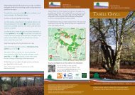
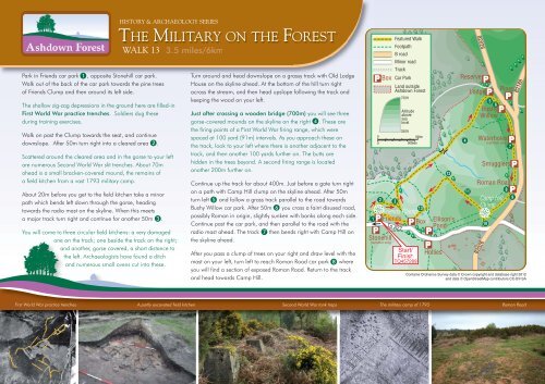
HISTORY & ARCHAEOLOGY SERIES<br />
THE MILITARY ON THE FOREST<br />
WALK 13<br />
3.5 miles/6km<br />
Park in Friends car park 1 , opposite Stonehill car park.<br />
<strong>Walk</strong> out of the back of the car park towards the pine trees<br />
of Friends Clump and then around its left side.<br />
The shallow zig-zag depressions in the ground here are filled-in<br />
First World War practice trenches. Soldiers dug these<br />
during training exercises.<br />
<strong>Walk</strong> on past the Clump towards the seat, and continue<br />
downslope. After 50m turn right into a cleared area 2 .<br />
Scattered around the cleared area and in the gorse to your left<br />
are numerous Second World War slit trenches. About 70m<br />
ahead is a small bracken-covered mound, the remains of<br />
a field kitchen from a vast 1793 military camp.<br />
About 20m before you get to the field kitchen take a minor<br />
path which bends left down through the gorse, heading<br />
towards the radio mast on the skyline. When this meets<br />
a major track turn right and continue for another 50m 3 .<br />
You will come to three circular field kitchens: a very damaged<br />
one on the track; one beside the track on the right;<br />
and another, gorse covered, a short distance to<br />
the left. <strong>Archae</strong>ologists have found a ditch<br />
and numerous small ovens cut into these.<br />
Turn around and head downslope on a grassy track with Old Lodge<br />
House on the skyline ahead. At the bottom of the hill turn right<br />
across the stream, and then head upslope following the track and<br />
keeping the wood on your left.<br />
Just after crossing a wooden bridge (700m) you will see three<br />
gorse-covered mounds on the skyline on the right 4 . These are<br />
the firing points of a First World War firing range, which were<br />
spaced at 100 yard (91m) intervals. As you approach these on<br />
the track, look to your left where there is another adjacent to the<br />
track, and then another 100 yards further on. The butts are<br />
hidden in the trees beyond. A second firing range is located<br />
another 200m further on.<br />
Continue up the track for about 400m. Just before a gate turn right<br />
on a path with Camp Hill clump on the skyline ahead. After 50m<br />
turn left 5 and follow a grass track parallel to the road towards<br />
Bushy Willow car park. After 50m 6 you cross a faint disused road,<br />
possibly Roman in origin, slightly sunken with banks along each side.<br />
Continue past the car park, and then parallel to the road with the<br />
radio mast ahead. The track 7 then bends right with Camp Hill on<br />
the skyline ahead.<br />
After you pass a clump of trees on your right and draw level with the<br />
mast on your left, turn left to reach Roman Road car park 8 where<br />
you will find a section of exposed Roman Road. Return to the track<br />
and head towards Camp Hill.<br />
Contains Ordnance Survey data © Crown copyright and database right 2012<br />
and data © OpenStreetMap contributors CC-BY-SA<br />
First World War practice trenches A partly excavated field kitchen Second World War tank traps<br />
The military camp of 1793 Roman Road