Cultural and Natural Resources Potentially Affected by Gulf Oil Spill
Cultural and Natural Resources Potentially Affected by Gulf Oil Spill
Cultural and Natural Resources Potentially Affected by Gulf Oil Spill

Create successful ePaper yourself
Turn your PDF publications into a flip-book with our unique Google optimized e-Paper software.
<strong>Cultural</strong> <strong>Resources</strong> GIS<br />
WASO<br />
National Park Service<br />
U.S. Department of the Interior<br />
ne<br />
St John<br />
Baptist<br />
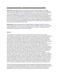
<strong>Cultural</strong> <strong>and</strong> <strong>Natural</strong> <strong>Resources</strong> <strong>Potentially</strong> <strong>Affected</strong> <strong>by</strong> <strong>Gulf</strong> <strong>Oil</strong> <strong>Spill</strong><br />
Robert UAC<br />
St Charles<br />
Lafourche<br />
LA<br />
Washington<br />
St Tammany<br />
Lake<br />
Pontchartrain<br />
Jean Lafitte<br />
NHP<br />
Lake Jefferson<br />
Salvador<br />
Timbalier<br />
Bay<br />
Timbalier I.<br />
FILE: 07JuneCloseupMapPublic.pdf<br />
Pearl River<br />
Ft. Pike<br />
Plaquemines<br />
Barataria<br />
Bay<br />
Hancock<br />
Rocket Propulsion<br />
Test Complex<br />
Bayou Sauvage<br />
NWR<br />
Ft. Macomb<br />
Orleans<br />
Lake<br />
Borgne<br />
New Orleans<br />
Little<br />
Lake<br />
Port<br />
Fourchon<br />
Big Branch<br />
Marsh NWR<br />
Elme rs I.<br />
Gr<strong>and</strong><br />
Isle<br />
Slidell<br />
Ft. Proctor<br />
Shell Beach<br />
St Bernard<br />
Ft. Livingston<br />
Produced <strong>by</strong> <strong>Cultural</strong> <strong>Resources</strong> GIS<br />
Black Bay<br />
Pass<br />
Christian<br />
Fts. Jackson<br />
<strong>and</strong> St. Philip<br />
Venice<br />
West<br />
Bay<br />
Southwest Pass<br />
Eloi Bay<br />
Breton<br />
Sound<br />
Harrison<br />
MS<br />
Biloxi<br />
<strong>Gulf</strong>port<br />
Cat I.<br />
Drum Bay<br />
Fr. Warehouse<br />
Ft. Mass.<br />
Light<br />
Oyster Bay<br />
Beauvoir<br />
Ship I.<br />
Ch<strong>and</strong>eleur<br />
Sound<br />
Br eto n I.<br />
East<br />
Bay<br />
Breton NWR<br />
Delta NWR<br />
South Pass<br />
Jackson<br />
MS S<strong>and</strong>hill<br />
Crane NWR<br />
0 5 10 20 30 40 50 60 70 80 90 100<br />
Miles<br />
(GUIS)<br />
Ch<strong>and</strong>eleur Light<br />
Gr. Gossier<br />
Isl<strong>and</strong>s<br />
Pass<br />
a Loutre<br />
07 June Map 2<br />
AL<br />
Gr<strong>and</strong> Bay<br />
Pascagoula NWR<br />
Gr<strong>and</strong><br />
Round Isl. Bay<br />
Light<br />
Horn I.<br />
Ch<strong>and</strong>eluer<br />
Isl<strong>and</strong>s<br />
Theodore<br />
Petit Bois I.<br />
<strong>Gulf</strong><br />
Mobile<br />
Dauphin I.<br />
Mexico<br />
Mobile<br />
Mobile<br />
Middle Bay<br />
Light<br />
Bay<br />
Baldwin<br />
Ft. Gaines Bon Secour<br />
NWR<br />
Ft. Morgan<br />
S<strong>and</strong> Isl.<br />
Light<br />
of<br />
Orange<br />
Beach<br />
FL<br />
Escambia<br />
Santa Rosa<br />
Ft. Barrancas<br />
USNAS<br />
Ft. Pickens<br />
Pensacola<br />
(GUIS)<br />
Santa Rosa I.<br />
07 June <strong>Oil</strong> Plume Forecast<br />
<strong>Spill</strong> Density (NOAA)<br />
Heavy<br />
Medium<br />
Light<br />
"Offshore"<br />
Uncertainty<br />
<strong>Potentially</strong> Beached <strong>Oil</strong> 07 June<br />
Archived <strong>Potentially</strong> Beached <strong>Oil</strong><br />
(Cumulative since 10 May)<br />
National Historic L<strong>and</strong>marks (13)<br />
National Register Properties (1,291)<br />
National <strong>Natural</strong> L<strong>and</strong>marks (7)<br />
Federal Disaster Response<br />
Staging Areas (18)<br />
National Parks, Monuments,<br />
Seashores, Preserves (7)<br />
National Wildlife Refuges (20)<br />
NOAA Environmental Sensitivity<br />
Index (ESI) Area<br />
Map compiled 07 June 2010<br />
MAP APPROVED FOR GENERAL DISTRIBUTION