general geology of the northern san luis valley, colorado
general geology of the northern san luis valley, colorado
general geology of the northern san luis valley, colorado

Create successful ePaper yourself
Turn your PDF publications into a flip-book with our unique Google optimized e-Paper software.
<strong>the</strong> Villa Grove reentrant by Knepper and Marrs<br />
(1971).<br />
Although two large perennial streams (Saguache<br />
Creek and San Luis Creek) traverse <strong>the</strong> nor<strong>the</strong>rn<br />
Alamosa Basin, dissection <strong>of</strong> <strong>the</strong> <strong>valley</strong> floor is<br />
negligible. A well-developed bajada exists along<br />
<strong>the</strong> base <strong>of</strong> <strong>the</strong> Sangre de Cristo Range and most<br />
streams from this range sink into alluvial fans ra<strong>the</strong>r<br />
than connecting to San Luis Creek (Figs. 3, 4).<br />
topographic divide from <strong>the</strong> Rio Grande drainage<br />
basin to <strong>the</strong> south. Sandy basin fill around <strong>the</strong> sump<br />
area has been mobilized as eolian <strong>san</strong>d, which has<br />
been transported nor<strong>the</strong>ast and piled up into <strong>the</strong> 185<br />
m- high dunes (Fig. 5) <strong>of</strong> <strong>the</strong> Great Sand Dunes<br />
National Monument (Johnson, 1967).<br />
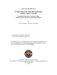
Fig. 3. View down <strong>the</strong> glaciated <strong>valley</strong> <strong>of</strong> Willow<br />
Creek, immediately north <strong>of</strong> Kit Carson Peak,<br />
looking west toward <strong>the</strong> <strong>valley</strong> floor and <strong>the</strong> Baca<br />
Grande land grant. In center foreground is Willow<br />
Park, an infilled lake basin impounded behind latest<br />
Pleistocene glacial moraines. Streams such as<br />
Willow Creek and <strong>the</strong> Crestone Creeks traverse<br />
glaci<strong>of</strong>luvial fans, only to sink into <strong>the</strong> <strong>valley</strong> floor.<br />
Fig. 4. View looking upstream (north) up <strong>the</strong> braided<br />
channel <strong>of</strong> Medano Creek, at <strong>the</strong> Great Sand Dunes<br />
National Monument. The active dune field is at left.<br />
Medano Creek is reknown for its surging flow<br />
during <strong>the</strong> spring run<strong>of</strong>f season (Schumm et al.,<br />
1982). During peak flow (ca. 50 cfs at <strong>the</strong> range<br />
front), <strong>the</strong> creek flows for about 8 km before it sinks<br />
into <strong>the</strong> <strong>valley</strong> floor.<br />
At <strong>the</strong> low point in <strong>the</strong> basin, <strong>the</strong> San Luis Lakes<br />
comprise a hydrologic sump, separated by a low<br />
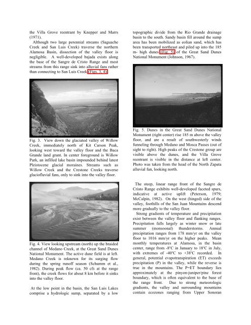
Fig. 5. Dunes in <strong>the</strong> Great Sand Dunes National<br />
Monument (right center) rise 185 m above <strong>the</strong> <strong>valley</strong><br />
floor, and are a result <strong>of</strong> southwesterly winds<br />
funneling through Medano and Mosca Passes (out <strong>of</strong><br />
sight to right). High peaks <strong>of</strong> <strong>the</strong> Crestone group are<br />
visible above <strong>the</strong> dunes, and <strong>the</strong> Villa Grove<br />
reentrant is visible in <strong>the</strong> distance at left center.<br />
Photo was taken from <strong>the</strong> head <strong>of</strong> <strong>the</strong> North Zapata<br />
alluvial fan, looking north.<br />
The steep, linear range front <strong>of</strong> <strong>the</strong> Sangre de<br />
Cristo Range exhibits well-developed faceted spurs,<br />
indicative at active uplift (Peterson, 1979;<br />
McCalpin, 1982). On <strong>the</strong> west (hinged) side <strong>of</strong> <strong>the</strong><br />
<strong>valley</strong>, foothills <strong>of</strong> <strong>the</strong> San Juan Mountains descend<br />
more gradually to <strong>the</strong> <strong>valley</strong> floor.<br />
Strong gradients <strong>of</strong> temperature and precipitation<br />
exist between <strong>the</strong> <strong>valley</strong> floor and flanking ranges.<br />
Precipitation falls largely as winter snow or late<br />
summer (monsoonal) thunderstorms. Annual<br />
precipitation ranges from 178 mm/yr on <strong>the</strong> <strong>valley</strong><br />
floor to 1016 mm/yr on <strong>the</strong> higher peaks. Mean<br />
monthly temperatures at Alamosa, in <strong>the</strong> basin<br />
center, range from -8 o C in January to 18 o C in July,<br />
with extremes <strong>of</strong> -40 o C to +38 o C recorded. In<br />
<strong>general</strong>, potential evapotranspiration (ET) exceeds<br />
precipitation (P) in <strong>the</strong> <strong>valley</strong>, while <strong>the</strong> reverse is<br />
true in <strong>the</strong> mountains. The P=ET boundary lies<br />
approximately at <strong>the</strong> pinyon-juniper/pine forest<br />
boundary, which is <strong>of</strong>ten equivalent to <strong>the</strong> base <strong>of</strong><br />
<strong>the</strong> range front. Due to strong meteorologic<br />
gradients, <strong>the</strong> <strong>valley</strong> and surrounding mountains<br />
contain ecozones ranging from Upper Sonoran