Welland Canal - City of Port Colborne
Welland Canal - City of Port Colborne
Welland Canal - City of Port Colborne

Create successful ePaper yourself
Turn your PDF publications into a flip-book with our unique Google optimized e-Paper software.
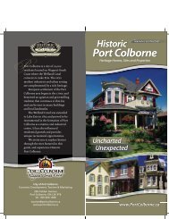
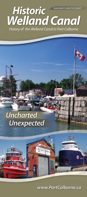
Historic<br />
NIAGARA’S SOUTH COAST<br />
<strong>Welland</strong> <strong>Canal</strong><br />
History <strong>of</strong> the <strong>Welland</strong> <strong>Canal</strong> in <strong>Port</strong> <strong>Colborne</strong><br />
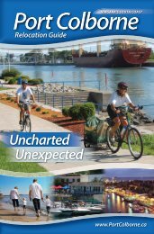
Uncharted<br />
Unexpected<br />
www.<strong>Port</strong><strong>Colborne</strong>.ca
The <strong>Welland</strong> <strong>Canal</strong> was originally established as solution<br />
to summer water shortages that plagued a grist mill operation<br />
near St. Catharines. In the early 1800s, the mill’s owner, William<br />
Hamilton Merritt, was searching for a new water supply at a<br />
higher elevation when he discovered the <strong>Welland</strong> River on the<br />
brow <strong>of</strong> the Niagara Escarpment. He was determined to divert<br />
this water supply into Twelve Mile Creek and thereby end his<br />
seasonal water problem. Merritt also had the idea <strong>of</strong> creating<br />
a deep enough channel to allow boats to pass through a series<br />
<strong>of</strong> locks down the escarpment into Twelve Mile Creek and on to<br />
Lake Ontario.<br />
In 1829 “Mr. Merritt’s ditch” was completed from <strong>Port</strong> Dalhousie<br />
on Lake Ontario to the summit <strong>of</strong> the escarpment at <strong>Port</strong><br />
Robinson. From there, boats travelled down into the <strong>Welland</strong><br />
River and on to Lake Erie via the upper Niagara River. The long<br />
route proved to be too time consuming and dangerous. As a<br />
result, in 1833 an extension <strong>of</strong> the canal was completed from the<br />
junction <strong>of</strong> a “feeder canal” at <strong>Welland</strong> through to Gravelly Bay,<br />
present-day <strong>Port</strong> <strong>Colborne</strong>.<br />
The canal was enlarged and widened in the 1850s and again in<br />
the 1880s. By the turn <strong>of</strong> the 20th century it was determined<br />
that a new, larger canal was required. Construction <strong>of</strong> the <strong>Port</strong><br />
<strong>Colborne</strong> section <strong>of</strong> the <strong>Welland</strong> <strong>Canal</strong> began in 1924, 100 years<br />
after the initial construction <strong>of</strong> Merritt’s original canal. The new<br />
<strong>Welland</strong> <strong>Canal</strong> was opened August 6, 1932.<br />
Due to a shortage <strong>of</strong> funds, the first <strong>Welland</strong> <strong>Canal</strong> utilized<br />
wooden locks. There were 40 such locks constructed with Lock<br />
40 at <strong>Port</strong> <strong>Colborne</strong> being the southernmost. Lock 40 was located<br />
adjacent to West Street at the junction <strong>of</strong> Sugarloaf Street.<br />
Two buildings from the first canal era still exist in their original<br />
locations: the Lakeview Hotel (62 West St.) and the Locktender’s<br />
House (corner <strong>of</strong> Sugarloaf and King Streets), also known as the<br />
“Stone House.” Both buildings were constructed circa 1835.<br />
Lighthouses & Breakwater<br />
The first lighthouse in <strong>Port</strong> <strong>Colborne</strong> was built in the 1830s, shortly<br />
after the <strong>Welland</strong> <strong>Canal</strong> was extended to Lake Erie. Since then, the<br />
entrance to the canal has been reconfigured several times, which<br />
has made it necessary for new lighthouses to be built to continue<br />
<strong>Port</strong> <strong>Colborne</strong> inner range lighthouse, built in 1903.<br />
providing a navigational beacon for ships entering the canal.<br />
At present, <strong>Port</strong> <strong>Colborne</strong> has two lighthouses on the western<br />
breakwater in Gravelly Bay. The inner range light was built in 1903<br />
consisting <strong>of</strong> a three-storey white concrete tower topped with a red<br />
parapet and lantern room. A large utility building is attached to it.<br />
The outer range light was built in 1928 when an older range light<br />
further inland was torn down. The new lighthouse is a one-anda-half<br />
storey white concrete structure that is square in shape. It is<br />
topped with a red parapet and lantern room and also houses <strong>Port</strong><br />
<strong>Colborne</strong>’s fog horn. On the eastern side <strong>of</strong> the canal entrance, ships<br />
are guided by beacons atop two modern, concrete towers.<br />
The Gravelly Bay break water protects Gravelly Bay and the entrance<br />
<strong>of</strong> the canal from rough water when there are storms over Lake<br />
Erie. It also protects from icedams in the winter. The wall is over 1.3<br />
kilometres in length and is ‘Y’ shaped. It was originally constructed<br />
in 1873, with extensions added in 1931.<br />
View <strong>of</strong> old locks and lift bridges from post card, circa 1930.<br />
Image courtesy <strong>of</strong> <strong>Port</strong> <strong>Colborne</strong> Historical and Marine Museum<br />
<strong>Port</strong> <strong>Colborne</strong> outer range lighthouse, built in 1928.
West Street Viewing Platform<br />
A viewing platform is located near the corner <strong>of</strong> West Street and<br />
Sugarloaf Street, where Lock 40 was once located. Lock 40 was the<br />
first lock on the canal when entering from Lake Erie. It was built in<br />
the early 1830s and removed during subsequent expansions <strong>of</strong> the<br />
canal. The viewing platform is the only vantage point along the entire<br />
<strong>Welland</strong> <strong>Canal</strong>s Corridor to see remnants <strong>of</strong> all four <strong>Welland</strong> <strong>Canal</strong>s.<br />
Along the west wall <strong>of</strong> the canal is the location <strong>of</strong> the channel <strong>of</strong> the<br />
first <strong>Welland</strong> <strong>Canal</strong>, then the locks <strong>of</strong> the second and third canals,<br />
and the inner harbour <strong>of</strong> the fourth or current <strong>Welland</strong> <strong>Canal</strong>.<br />
first, second, and third <strong>Welland</strong> <strong>Canal</strong>s. East Street was considered<br />
to be the centre <strong>of</strong> commerce for <strong>Port</strong> <strong>Colborne</strong> up until the end <strong>of</strong><br />
the First World War. During the construction <strong>of</strong> the fourth <strong>Welland</strong><br />
<strong>Canal</strong>, East Street and its buildings were torn down and the ground<br />
excavated to make way for the present shipping channel that flows<br />
under Bridge 21.<br />
Locks 26 & 27<br />
The locks <strong>of</strong> the second and third canal exist side-by-side near the<br />
Clarence Street Bridge. Lock 27 <strong>of</strong> the second <strong>Welland</strong> <strong>Canal</strong> is<br />
closest to West Street and was constructed <strong>of</strong> cut stone in the early<br />
View from West Street Viewing Platform.<br />
Historic West Street<br />
During the 19th century, <strong>Port</strong> <strong>Colborne</strong> developed into a thriving<br />
mercantile centre serving the marine trade. Ships waiting to pass<br />
through the canal tied up to the canal wall along West Street to<br />
purchase fresh produce, carry out repairs, or use the service <strong>of</strong><br />
tug boats. The nautical heritage <strong>of</strong> <strong>Port</strong> <strong>Colborne</strong> is still reflected<br />
Looking north through lock 26, built in the 1880s and used into the 1920s.<br />
1850s. On the second <strong>Welland</strong> <strong>Canal</strong>, lock 27 was the first lock<br />
on the canal when entering from Lake Erie. During its lifetime it<br />
operated as a “lift lock,” allowing a ship to sail “up” into the canal<br />
from Lake Erie. It wasn’t until the third canal era, 30 years later, that<br />
the canal was able to attain a water-level close to that <strong>of</strong> Lake Erie.<br />
When built, lock 27 was 46 metres in length.<br />
For the third <strong>Welland</strong> <strong>Canal</strong>, the total number <strong>of</strong> locks was reduced<br />
from 27 to 26. A new lock was constructed directly beside old lock<br />
27 in the 1880s, and these twin locks became known as lock 26.<br />
These twin locks allowed shipping traffic to flow in both directions.<br />
Again, lock 26 was the first lock when entering the canal from<br />
Lake Erie. The function <strong>of</strong> lock 26 was that <strong>of</strong> a “guard lock” – to<br />
regulate the seasonally fluctuating levels <strong>of</strong> Lake Erie, much as the<br />
present lock 8 does. Lock 26 was 82 metres long when it was built.<br />
The nautical tradition is continued on West Street with the presence <strong>of</strong><br />
marine repair shops.<br />
in many <strong>of</strong> the buildings that line West Street. Allied Marine &<br />
Industrial, a ship servicing and repair company, continues the long<br />
tradition <strong>of</strong> having a workshop on West Street across from the canal.<br />
An <strong>of</strong>ten forgotten aspect <strong>of</strong> <strong>Port</strong> <strong>Colborne</strong>’s history is East Street,<br />
which stood opposite to West Street on the eastern side <strong>of</strong> the<br />
Weir Channels<br />
A weir channel is necessary to maintain a continuous flow <strong>of</strong> water<br />
through the canal. Weir channels typically provide the supply <strong>of</strong><br />
water for filling locks and also an area where large volumes <strong>of</strong> water<br />
can be discharged during the emptying <strong>of</strong> locks. All four <strong>Welland</strong><br />
<strong>Canal</strong>s have utilized weir channels in their operation and they are<br />
usually found parallel to the lock.<br />
Two weir channels were constructed in the 1880s along with lock<br />
26 <strong>of</strong> the third canal parallel to lock 27. One was constructed as an<br />
“open weir” which was nearest to the lock. It has since been filled in<br />
and is part <strong>of</strong> the <strong>Port</strong> Promenade. The second, a covered or “tunnel<br />
weir,” is still located under West Street and is located to the west <strong>of</strong>
Curved limestone entrance to the covered weir that still flows under West Street.<br />
the former open weir. The tunnel has its inlet near Charlotte Street<br />
and its outlet just north <strong>of</strong> the lift bridge. Legend has it rum-runners<br />
used the tunnel during prohibition to smuggle alcohol from the West<br />
Street taverns to the United States.<br />
Bridge 21, built in 1929, still serves as a vital link connecting east and west<br />
<strong>Port</strong> <strong>Colborne</strong>.<br />
Bridge 20, also a lift bridge, stood just north <strong>of</strong> Bridge 21. Built in<br />
1929 by the Canadian National Railway, the bridge served passenger<br />
and freight traffic. When the <strong>Port</strong> <strong>Colborne</strong> Harbour Railway was<br />
completed in the mid 1990s connecting <strong>Port</strong> <strong>Colborne</strong> to railway lines<br />
on the western side <strong>of</strong> the canal, Bridge 20 became unnecessary.<br />
It was removed in 1997.<br />
Photo <strong>of</strong> northern end <strong>of</strong> the weir channels and weir dam prior to the open<br />
weir channel being filled, circa 1920.<br />
Image courtesy <strong>of</strong> <strong>Port</strong> <strong>Colborne</strong> Historical and Marine Museum.<br />
<strong>Canal</strong> Crossings<br />
The Hopkins Swing Bridge connected East Street and West Street<br />
prior to the construction <strong>of</strong> the current canal channel in the 1920s. It<br />
received its nickname from Samuel Hopkins, who operated a supply<br />
business across from the bridge on West Street. After the opening <strong>of</strong><br />
the fourth canal, the swing bridge was no longer necessary and was<br />
removed. The stone abutments <strong>of</strong> the swing bridge can still be seen at<br />
the southern tip <strong>of</strong> the stone bulwark between the two lock channels.<br />
The Clarence Street Lift Bridge, known as Bridge 21, is one <strong>of</strong> three<br />
remaining lift bridges operating on the <strong>Welland</strong> <strong>Canal</strong>. Built in 1929,<br />
the structure uses simple electric motors and counterweights to raise<br />
the deck high above passing ships allowing for a clearance <strong>of</strong> 36.5<br />
metres. The raising or lowering <strong>of</strong> the bridge takes about 90 seconds.<br />
The western bridge approach over locks 26 and 27 was added when<br />
Bridge 21 was constructed, making these locks inoperable.<br />
Bridges 20 and 21 as they stood between 1929 and 1997, circa 1985.<br />
Still present is the old railway bridge that crossed the twin locks and<br />
later served as the western approach to Bridge 20. This swing bridge<br />
was constructed with the third <strong>Welland</strong> <strong>Canal</strong> in the 1880s for the<br />
Buffalo and Lake Huron Railroad, a precursor to Canadian National<br />
Railway. In numerous locations the steel <strong>of</strong> the bridge bears the letter<br />
mark <strong>of</strong> the Carnegie Steel Company. The gear system on which the<br />
bridge pivoted is still visible between the bridge and centre support<br />
pylon.
Weir Dam – Main Street<br />
The bridge was built as part <strong>of</strong> the fourth <strong>Welland</strong> <strong>Canal</strong>, replacing<br />
a swing bridge over the first, second, and third canals at the same<br />
site. The dam beneath this bridge regulates the amount <strong>of</strong> water<br />
downstream in the canal, including seven lift locks stretching to<br />
Lake Ontario and a hydro-electric generating plant at Decew Falls in<br />
St. Catharines.<br />
The railway swing bridge, built in 1880s, with Canadian National Railway<br />
marking on the side.<br />
The Island<br />
North <strong>of</strong> Clarence Street, the first three canals followed the west<br />
channel. This route made use <strong>of</strong> an old creek that passed through<br />
the village <strong>of</strong> Stonebridge, later named Humberstone. The natural<br />
watercourse was widened several times and augmented by<br />
limestone blocks serving as retaining walls.<br />
Weir dam at Main Street West.<br />
Lock 8 and Lock 8 Gateway Park<br />
Lock 8 on the east side <strong>of</strong> the Island serves as a guard lock for the<br />
canal, raising or lowering ships one to four feet, depending on the<br />
Lake Erie water levels. At 420 metres, it is one <strong>of</strong> the longest canal<br />
locks in the world. Being the southernmost lock on the present-day<br />
<strong>Welland</strong> <strong>Canal</strong>, many ships use time in the lock to have supplies<br />
replenished, switch crew, and undergo minor repairs.<br />
South point <strong>of</strong> “The Island”- weir channel to left, lock 8 to right.<br />
Early in the 20th century it became feasible to blast through<br />
bedrock and construct a straighter, more direct eastern channel.<br />
It was accomplished in 1932 with the construction <strong>of</strong> the current<br />
<strong>Welland</strong> <strong>Canal</strong>. The area surrounded by the east and west canal<br />
channels is known locally as “The Island.” It was created by the<br />
cutting <strong>of</strong> the new fourth canal channel in the 1920s and the<br />
existence <strong>of</strong> the curved first, second, and third canal channels,<br />
thereby surrounding the entire area with water. Access to The Island<br />
from the east must be made by either <strong>of</strong> the jack-knife bridges at<br />
Lock 8. From the west, The Island can be accessed over the weir<br />
control structure at Main Street West, the weir crossing at Killaly<br />
Street West, or the pedestrian bridge at Derek Point. The western<br />
crossings pass over the route <strong>of</strong> the first, second, and third canals.<br />
Ship entering lock 8, under jack-knife bridge (Bridge 19).<br />
Lock 8 Gateway Park, adjacent to Lock 8 has an elevated viewing<br />
platform to watch ships enter and exit the lock. The single-leaf<br />
rolling bascule, or jack-knife bridges at each end provide vehicle<br />
access to “The Island” and the east and west sides <strong>of</strong> the <strong>City</strong>.
Ramey’s Bend<br />
At Main Street, the old canal channel curves slowly eastward to a<br />
point where it meets the present-day canal. The location is known as<br />
Ramey’s Bend. After Ramey’s Bend, old and new channels co-exist<br />
to a point where a 1972 diversion allows the <strong>Welland</strong> <strong>Canal</strong> to<br />
bypass the <strong>City</strong> <strong>of</strong> <strong>Welland</strong>. Over the years, the construction <strong>of</strong> new<br />
shipping channels has moved the canal away from the commercial<br />
districts <strong>of</strong> St. Catharines, Thorold, and <strong>Welland</strong>. Only <strong>Port</strong> <strong>Colborne</strong>’s<br />
Downtown Business District remains bisected by the waterways.<br />
This photo <strong>of</strong> Ramey’s Bend, circa 1980, shows the current alignment <strong>of</strong> the<br />
canal and remnants <strong>of</strong> the old alignment.<br />
Old Robin Hood Flour Mill<br />
The old Robin Hood mill is situated on the west bank <strong>of</strong> the “old”<br />
<strong>Welland</strong> <strong>Canal</strong>. The mill was built in the early 1940s to meet<br />
demand for flour during the Second World War. The large steel<br />
structure to the left <strong>of</strong> the building was a guide for the 15-storey<br />
ship unloader called the “marine tower” (no longer used), which<br />
rolled back and forth on railway tracks. The elevator itself has a<br />
capacity <strong>of</strong> 2.25-million bushels <strong>of</strong> wheat.<br />
<strong>Port</strong> <strong>Colborne</strong> remains an active location for grain storage and<br />
milling. Both ends <strong>of</strong> the canal in <strong>Port</strong> <strong>Colborne</strong> are flanked by<br />
grain storage and milling facilities. <strong>Port</strong> <strong>Colborne</strong>’s location at the<br />
Lake Erie entrance to the <strong>Welland</strong> <strong>Canal</strong> and easy access to rail<br />
transportation has made the grain industry an important local<br />
economic activity.<br />
H.H. Knoll<br />
Lakeview<br />
Park<br />
Robin Hood mill on the weir channel.
<strong>Port</strong> <strong>Colborne</strong> is a city <strong>of</strong> 19,000<br />
residents located on Niagara’s South<br />
Coast where the <strong>Welland</strong> <strong>Canal</strong><br />
connects to Lake Erie. The city’s<br />
modern industries and urban setting<br />
are complemented by a rich heritage.<br />
European settlement <strong>of</strong> the <strong>Port</strong><br />
<strong>Colborne</strong> area began in the 1790s, and<br />
bestowed an agrarian and grist-milling<br />
tradition that continues to this day<br />
and can be seen in many buildings<br />
and local landmarks.<br />
The <strong>Welland</strong> <strong>Canal</strong> was extended<br />
to Lake Erie in 1833 and proved to be<br />
instrumental in the formation <strong>of</strong> <strong>Port</strong><br />
<strong>Colborne</strong> as a marine and industrial<br />
centre. It has also influenced<br />
residential growth and provides<br />
unique recreational opportunities.<br />
We invite you to explore history<br />
through the sites featured in this<br />
guide, and experience Historic<br />
<strong>Port</strong> <strong>Colborne</strong>.<br />
<strong>City</strong> <strong>of</strong> <strong>Port</strong> <strong>Colborne</strong><br />
Economic Development, Tourism & Marketing<br />
296 Fielden Avenue<br />
<strong>Port</strong> <strong>Colborne</strong>, ON L3K 4T6<br />
Tel.: 905-834-1668<br />
tourism@portcolborne.ca<br />
www.portcolborne.ca