SafeSea Product Brochure (English) - Ocean Signal
SafeSea Product Brochure (English) - Ocean Signal
SafeSea Product Brochure (English) - Ocean Signal

Create successful ePaper yourself
Turn your PDF publications into a flip-book with our unique Google optimized e-Paper software.
GMDSS<br />
GMDSS is an internationally operated system for<br />
Safety of Life at Sea (SOLAS). Developed by the<br />
International Maritime Organisation, the GMDSS was<br />
originally conceived for commercial shipping, but the<br />
systems used are equally applicable to all maritime<br />
users. The underlying principle is that ships should<br />
have at least two means of transmission of a distress<br />
alert to both shore infrastructure and to other ships.<br />
Additional equipment is carried to provide location<br />
and communication aids for use during the search<br />
and rescue phase. The <strong>SafeSea</strong> range of products<br />
from <strong>Ocean</strong> <strong>Signal</strong> provides a total solution for this<br />
class of equipment.<br />
EPIRB – how it works<br />
<strong>Ocean</strong> <strong>Signal</strong> EPIRBs operate in the 406MHz<br />
satellite band monitored by Cospas-Sarsat,<br />
ensuring a signal can be located wherever it is<br />
activated around the globe.<br />
On activation, the EPIRB commences<br />
transmission of a distress alert, which is picked<br />
up by two groups of satellites. The geostationary<br />
(GEOSAR) satellites will typically receive the alert<br />
first, but these satellites do not have the ability<br />
to generate location information and do not cover<br />
the Polar Regions.<br />
LEOSAR Satellites<br />
The second group of low earth orbiting (LEOSAR)<br />
satellites give complete global coverage, including<br />
the Polar Regions. As each satellite passes over<br />
an active EPIRB, it can calculate the approximate<br />
location (typically within 5Nm) of the beacon, using<br />
Doppler processing of the signal.<br />
The satellites pass the received alerts to Cospas-<br />
Sarsat headquarters, where it is then passed to the<br />
relevant National Rescue Coordination Centre.<br />
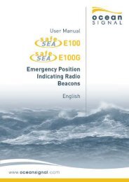
EPIRB without GPS: The <strong>SafeSea</strong> E100 EPIRB will<br />
have initiated a rescue attempt almost immediately<br />
after activation, but because of the nature of the<br />
satellite location process your position may not be<br />
known for some time afterwards as it depends on<br />
the orbit of the LEOSAR satellites which can take up<br />
to an hour to come into view.<br />
EPIRB with GPS: The <strong>SafeSea</strong> E100G EPIRB will<br />
transmit its known location as soon as a position<br />
fix has been obtained by the built-in GPS. These<br />
transmissions will be picked up by both types of<br />
satellite. This provides two significant advantages.<br />
• Immediate location of the vessel in distress<br />
• Excellent positional accuracy of the distress<br />
GEOSAR Satellites<br />
Whilst every effort has been made to ensure the information in this brochure is accurate,<br />
products and specifications may be changed without notice.<br />
www.oceansignal.com