ORGANIZER VrnjaÅka Banja, Serbia
ORGANIZER VrnjaÅka Banja, Serbia
ORGANIZER VrnjaÅka Banja, Serbia

Create successful ePaper yourself
Turn your PDF publications into a flip-book with our unique Google optimized e-Paper software.
proposed screen is with the total length of 6999 m and protects the open pit mine from western,<br />
northern and eastern sides from groundwater inflow (Figure 2). Western and northern layouts are<br />
identical in Variants 2 and 3.<br />
It was included in the defense system from groundwater on 1 st January 2008. The thickness of the<br />
screen amounts 1.0 m, and the hydraulic conductivity of the screen filling is K = 1x10 -8 m/s<br />
[11 Subaranovic et al., 2006], [12 Milosevic et al., 2007].<br />
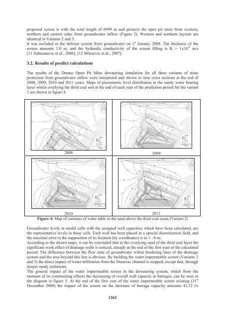
3.2. Results of predict calculations<br />
The results of the Drmno Open Pit Mine dewatering simulation for all three variants of mine<br />
protection from groundwater inflow were interpreted and shown in time cross sections at the end of<br />
2008, 2009, 2010 and 2011 years. Maps of piezometric level distribution in the sandy water bearing<br />
layer which overlying the third coal soil at the end of each year of the prediction period for the variant<br />
2 are shown in figure 4.<br />
2008 2009<br />
2010 2011<br />
Figure 4: Map of contours of water table in the sand above the third coal seam (Variant 2)<br />
Groundwater levels in model cells with the assigned well capacities which have been calculated, are<br />
the representative levels in these cells. Each well has been placed in a special discretization field, and<br />
the maximal error in the supposition of its location (by coordinates) is to ± ~6 m.<br />
According to the shown maps, it can be concluded that in the overlying sand of the third coal layer the<br />
significant work effect of drainage wells is noticed, already at the end of the first year of the calculated<br />
period. The difference between the flow state of groundwater within bordering lines of the drainage<br />
system and the area beyond this line is obvious. By building the water impermeable screen (Variants 2<br />
and 3) the direct impact of water infiltration from the Dunavac channel is stopped, except that, through<br />
deeper sandy sediments.<br />
The general impact of the water impermeable screen in the dewatering system, which from the<br />
moment of its constructing affects the decreasing of overall well capacity in barrages, can be seen in<br />
the diagram in figure 5. At the end of the first year of the water impermeable screen existing (31 st<br />
December 2008) the impact of the screen on the decrease of barrage capacity amounts 42.32 l/s<br />
1262