Moab Happenings
Moab Happenings
Moab Happenings

Create successful ePaper yourself
Turn your PDF publications into a flip-book with our unique Google optimized e-Paper software.
www.moabhappenings.com<br />
SCENIC ROAD HAPPENINGS<br />
Highway 128 - The River Road<br />
Utah Highway 128, also known locally as the “River<br />
Road”, parallels the Colorado River as it winds its way<br />
between sheer towering cliffs 1,000’ tall, fantastic rock<br />
formations, and vast breathtakingly panoramic valleys.<br />
Originally created as a travel corridor linking <strong>Moab</strong> and<br />
several small (now vanished) communities with the railroad<br />
at Cisco (which is also disappearing), the River Road now<br />
is popular with campers, bicyclists, hikers, river rafters and<br />
those just out to enjoy a highly scenic drive. It is for the last<br />
group that this road log is intended to serve<br />
To begin your trip up the River Road, start at the<br />
intersection of Main and Center Streets in <strong>Moab</strong>, and<br />
proceed north on Main Street (US Highway 191) 2.4 miles<br />
to the intersection of US 191 and Utah Highway 128 (the<br />
River Road). Turn right, and reset your tripmeter. If you<br />
cross over the river, you just missed your turn!<br />
Before you start upcanyon, a note of caution: Highway<br />
128 is generally narrow with no shoulder to speak of, and<br />
bicyclists in your lane are a regular sight. Be respectful,<br />
and give bicyclists a wide berth. Also, please remain alert<br />
for the possibility of rocks in the road-the highway is often<br />
bounded on the right side by sheer cliffs, and rockfalls can<br />
occur at any time.<br />
Mile 0.0 Across Highway 128 is Lion’s Park. As of<br />
the time of this writing, Lion’s Park was being used as a<br />
staging area for the construction of a new bridge across<br />
the Colorado River. Normally, Lion’s Park provides a<br />
shady retreat beneath the expansive branches of numerous<br />
Cottonwood trees. There any several informational kiosks<br />
here that discuss the history of <strong>Moab</strong>, the Colorado River,<br />
the Old Spanish Trail, and more.<br />
As you proceed down the River Road, you will notice<br />
over the first several miles that the geologic layers fall<br />
and rise. This is due to the movement of deep subsurface<br />
salt deposits that have lifted the landscape (anticlines)<br />
and dropped it (synclines). This salt flowage is ultimately<br />
responsible for most of the dramatic topography of the<br />
<strong>Moab</strong> Area (excluding the La Sal Mountains).<br />
Mile 1.0 Goose Island overlook. There are more<br />
informative kiosks here that discuss riverway rules and<br />
regulations, camping facilities, and wildlife such as<br />
endangered fishes in the Colorado River, bird species, river<br />
otters and more.<br />
Mile 1.4 Goose Island campground. There are<br />
restrooms here, and at all campgrounds farther upriver.<br />
As you continue your drive, you may notice piles of<br />
river gravel across the river upon the sandstone, 40 feet or<br />
more above the river. This gravel was deposited when the<br />
river was at that level.<br />
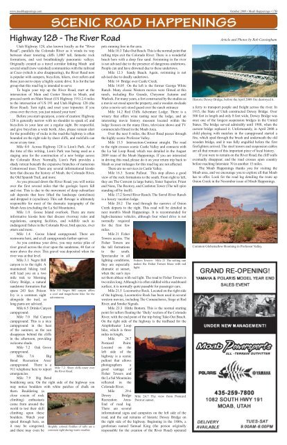
Mile 3.1 Negro Bill<br />
canyon is to the right. A<br />
maintained hiking trail<br />
will lead you on a two<br />
mile trek to Morning<br />
Glory Bridge, a natural<br />
sandstone formation that<br />
spans 243 feet. Poison<br />
Ivy is a common sight<br />
alongside the trail, so<br />
long pants are advised.<br />
Mile 6.5 Drinks Canyon<br />
campground.<br />
Mile 7.0 Hal Canyon<br />
campground. This is a nice<br />
campground in the heat<br />
of the summer, as the sun<br />
disappears behind the cliffs<br />
in the afternoon, providing<br />
welcome shade.<br />
Mile 7.2 Oak Grove<br />
campground.<br />
Mile 7.6 Big<br />
Bend Recreation Area/<br />
campground. There is a<br />
911 telephone here to report<br />
emergencies.<br />
Mile 7.9 Big Bend<br />
bouldering area. On the right side of the highway you<br />
may notice boulders with white patches of chalk on<br />
them. Bouldering (a<br />
close cousin of rock<br />
climbing) enthusiasts<br />
come from around the<br />
world to test their skill<br />
climbing upon these<br />
boulders. Watch your<br />
speed through here, as<br />
it may be congested,<br />
and there may even be<br />
Mile 3.0 Negro Bill canyon offers<br />
a cool and magnificent hike for the<br />
adventurous.<br />
Mile 7.2 Sheer cliffs tower over<br />
the River Road.<br />
Brightly colored flotillas of rafts are a<br />
common sight during warm weather.<br />
pets running free in the area.<br />
Mile 10.3 Take-Out Beach. This is the normal point that<br />
rafting trips exit the Colorado River. There is a wonderful<br />
beach here with a deep fine sand. Swimming in the river<br />
is not advised due to the presence of dangerous undertows.<br />
People can and have drowned due to these undertows.<br />
Mile 12.3 Sandy Beach. Again, swimming is not<br />
advised due to deadly undertows.<br />
Mile 14 Bridge over Castle Creek.<br />
Mile 14.05 On the left is the former George White<br />
Ranch. Many classic Western movies were filmed at this<br />
ranch, including Rio Grande, Cheyenne Autumn and<br />
Warlock. For many years, a fort constructed by the studios as<br />
a movie set stood upon the property, and a wooden stockade<br />
(also a movie set) stood guard over the ranch entrance<br />
Mile 14.2 Red Cliffs Adventure Lodge. There is a<br />
winery that offers wine tasting near the lodge, and an<br />
interesting movie history museum located within the<br />
lodge focuses on the many films, television shows and TV<br />
commercials filmed in the <strong>Moab</strong> Area.<br />
Over the next 8 miles, the River Road passes through<br />
the highly scenic Professor Valley.<br />
Mile 15.5 Intersection-Continue straight. The road<br />
to the right crosses scenic Castle Valley and connects with<br />
the La Sal Loop Road, which was detailed in the August<br />
2009 issue of the <strong>Moab</strong> <strong>Happenings</strong>. If you are interested<br />
in driving this road, please do it on your return trip back to<br />
<strong>Moab</strong> so your mileages for this road log are not affected.<br />
There are no services in Castle Valley.<br />
Mile 16.3 Scenic Pullout. This stop allows a good<br />
view of the rock formations to the south. From right to left,<br />
they are The Convent (a large butte), Sister Superior, Priest<br />
and Nuns, The Rectory, and Castleton Tower (The tall spire<br />
standing off by itself).<br />
Mile 17.2 Sorrel River Ranch. The Sorrel River Ranch<br />
is a luxury vacation lodge.<br />
Mile 20.2 The road through the narrows of Onion<br />
Creek departs to the right. This road will be detailed in<br />
next month’s <strong>Moab</strong> <strong>Happenings</strong>. It is recommended for<br />
high-clearance vehicles, although four wheel drive is not<br />
normally required<br />
for the first few<br />
miles.<br />
Mile 21 Fisher<br />
Towers access. The<br />
Fisher Towers are<br />
the tall formations<br />
to the south.<br />
Spectacular in all<br />
lighting conditions,<br />
they are especially<br />
dramatic at sunset,<br />
when the sun’s rays<br />
set them ablaze with red light. The road to Fisher Towers is<br />
two miles long. Although it is often riddled with a washboard<br />
surface, it is normally quite passable for passenger cars.<br />
Mile 21.5 Locomotive Rock. Located on the right side<br />
of the highway, Locomotive Rock has been used in several<br />
western movies, including The Comancheros, Siege at Red<br />
River, and Smoke Signals.<br />
Mile 23.3 Hittle Bottom. This is the normal starting<br />
point for rafters floating the ‘Daily’ section of the Colorado<br />
River, with the end point of the trip being Take-Out Beach.<br />
On the right side of the highway is the trailhead for the<br />
Amphitheater Loop<br />
hike, which is three<br />
miles in length.<br />
Mile 24.7<br />
Postcard Point.<br />
Located on the<br />
left side of the<br />
highway is a scenic<br />
pullout that allows<br />
photographers a<br />
good vantage of<br />
Fisher Towers and<br />
the La Sal Mountains<br />
reflected in the<br />
Colorado River.<br />
Mile 29.6<br />
Fishers Towers- Mile 21 The setting sun<br />
makes the Fisher Towers blaze with red<br />
light.<br />
Dewey Bridge Mile 24.7 The view from Postcard<br />
Recreation Area- Point at sunset.<br />
End of road log.<br />
There are several<br />
informational signs and campsites on the left side of the<br />
road, and the sad remains of historic Dewey Bridge on<br />
the right side of the highway. Beginning in the 1880s, a<br />
gentleman named Samual King (the person originally<br />
responsible for the creation of the River Road) operated<br />
<br />
Article and Photos by Rob Cassingham<br />
Historic Dewey Bridge, before the April 2008 fire destroyed it.<br />
a ferry to transport people and freight across the river. In<br />
1915, the State of Utah constructed Dewey Bridge. Over<br />
500 feet in length and only 8 feet wide, Dewey Bridge was<br />
once one of the longest suspension bridges in the United<br />
States. The bridge served admirably until 1988, when the<br />
current bridge replaced it. Unfortunately, in April 2008 a<br />
child playing with matches in the campground started a<br />
fire, which sped through the brush and underneath the old<br />
wooden bridge, and it was fully engulfed before the first<br />
firefighters arrived. The steel towers and suspension cables<br />
are all that remain of this important piece of local history.<br />
If you were to remain on the River Road, the cliff walls<br />
eventually disappear, and the road crosses open country<br />
before reaching Interstate 70 in another 15 miles.<br />
The <strong>Moab</strong> <strong>Happenings</strong> thanks you for visiting the<br />
<strong>Moab</strong> area, and we encourage you to explore all that <strong>Moab</strong><br />
has to offer. Look for the road log detailing the route up<br />
Onion Creek in the November issue of <strong>Moab</strong> <strong>Happenings</strong>.<br />
Common Globemallow blooming in Professor Valley.