Simien Mountain Trek ⢠Ethiopia 14 Days (ex Addis Ababa)
Simien Mountain Trek ⢠Ethiopia 14 Days (ex Addis Ababa)
Simien Mountain Trek ⢠Ethiopia 14 Days (ex Addis Ababa)

Create successful ePaper yourself
Turn your PDF publications into a flip-book with our unique Google optimized e-Paper software.
preserved and medieval looking castles, dating from as early as 1650. Gondar is well placed, watered by mountain<br />
torrents and sitting at an altitude of 2300 meters. There are views from the city, which <strong>ex</strong>tend across the surrounding<br />
farmland to Lake Tana, 35kilometers to the south. This is a historic settlement with an atmosphere of mystery.<br />
Overnight at the Goha Hotel, which is situated on a hill overlooking the town.<br />
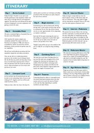
Day 3: Debark- Sankaber<br />
In the cool of the morning, we will make the 2 to 3 hour drive from Gondar to Debark. This is a small market town at an<br />
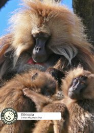
altitude of 2700 meters close to the boundary of the <strong>Simien</strong> <strong>Mountain</strong>s National Park. Here, an armed scout-one of the<br />
park regulations joins you. Then we drive towards Sankaber where you walk the last couple of hours of the day to your<br />
camp for the night.<br />
Day 4: Sankaber – Geech<br />
Today we will meet the muleteers and the trek equipment is loaded on to their mules. Starting out, you descend in the<br />
Michwahtis valley and begin the climb up the other side, making a short diversion to see one of the most impressive<br />
sights in the <strong>Simien</strong> <strong>Mountain</strong>s, where the Jinbar River plummets into the Geech Abyss.<br />
Day 5: Geech – Chenek<br />
The route today takes us along the edge of the escarpment to the promontory and a small peak known as Imetgogo.<br />
From here you descend into an open, grassy valley filled with 3 and 4-meter tall giant Lobelias. The Chenek campsite<br />
offers superb views across to the opposite escarpment and the prominent peak of Imetgogo.<br />
Day 6: Chenek – Ambiquo<br />
To reach the village of Ambiquo at the foot of Ras Dejen, you must initially climb up above your camp towards Amba<br />
Bhawit (4477m.), the second highest mountain in the range. At 4200m you pass through Bhauit pass. Here, you will also<br />
get your first sighting of the Ras Dashen (4620m), the highest point in a wall of cliffs and peaks on the skyline. Crossing<br />
the Meshawa River after more than 1000 meters of descent, you climb steeply to the village of Ambiquo, where we will<br />
camp for the night.<br />
Day 7: Ambiquo – Summit Day<br />
Today’s climb to the highest point in <strong>Ethiopia</strong>, the summit of Ras Dejen, requires a dawn start. You climb slowly and<br />
steadily through giant Lobelia forests, passing the tiny, perched village of Mizma and gaining an area of open pasture<br />
where there are herds of cattle and goats with their attendant herdsmen. The triple-summited bulk of Ras Dejen looms<br />
above and it is far from obvious which of these is the highest. Finally, after 5 hours of ascent, you reach steeper, rocky<br />
ground and a short scramble to the cairned summit. We usually take an hours rest on top to enjoy the views that, in<br />
clear weather, <strong>ex</strong>tend to North of <strong>Ethiopia</strong>. A 3 hour descent takes you back to the campsite in Ambiquo.<br />
Day 8: Ambiquo – Arkwaziye<br />
Rather than retracing your trek to Sankaber (which is the usual <strong>Simien</strong> <strong>Mountain</strong>s trek) we have chosen to <strong>ex</strong>tend the<br />
itinerary and make the return towards Gondar through the lowlands, which will give you the chance to see a greater<br />
range of the <strong>Ethiopia</strong>n countryside. Descending from your camp at Ambiquo for an hour, you then have an easy 3-hour<br />
stroll, heading back westwards to the camping place in Arkwaziye (3600m.)<br />
Day 9: Arkwaziye – Loma<br />
A day of descent, as you head for the village of Makarabia in the region known as Lamo. You are leaving behind the high<br />
plateau and your route crosses several major ridges before dropping 1000meters alongside Ansiya River to the rarely<br />
visited lowlands. It becomes progressively warmer as you descend to the camp at Loma (2000m,).<br />
P i o n e e r E x p e d i t i o n s ● 4 M i n s t e r C h a m b e r s ● 4 3 H i g h S t r e e t ● W i m b o r n e ● D o r s e t ● B H 2 1 1 H R<br />
t 0 8 4 5 0 0 4 7 8 0 1 ● e i n f o @ p i o n e e r e x p e d i t i o n s . c o m