Proposed Critical Slopes Ordinance Change - Albemarle County
Proposed Critical Slopes Ordinance Change - Albemarle County
Proposed Critical Slopes Ordinance Change - Albemarle County

Create successful ePaper yourself
Turn your PDF publications into a flip-book with our unique Google optimized e-Paper software.
The current ordinance regulates the use of certain steep slopes called critical slopes. Any slope of 25%<br />
or greater (a rise or fall of 1 foot in a 4 foot run or approximately 14 degrees) is defined as a critical<br />
slope. Disturbance of a critical slope to establish any use requiring a building permit or site plan is not<br />
permitted unless the activity is one of the listed exempt activities or the Board of Supervisors grants a<br />
special exception. When disturbance is permitted, the current ordinance has no design standards that<br />
apply specifically to steep slopes.<br />
The proposed ordinance would still regulate activity on all slopes of 25% or greater. There would be no<br />
increase or decrease in the regulated areas. The proposal is to have two classes of slopes; “preserved”<br />
and “managed” and to establish design standards. Criteria were developed to determine which<br />
designation a steep slope area should carry. The criteria are not absolute as sometimes a specific area<br />
may have multiple characteristics.<br />
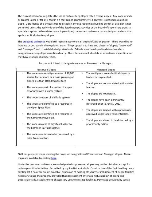
Factors which tend to designate an area as Preserved or Managed:<br />
Preserved <strong>Slopes</strong><br />
• The slopes are a contiguous area of 10,000<br />
square feet or more or a close grouping of<br />
slopes less than 10,000 square feet.<br />
• The slopes are part of a system of slopes<br />
associated with a water feature.<br />
• The slopes are part of a hillside system.<br />
• The slopes are identified as a resource in<br />
the Open Space Plan.<br />
• The slopes are identified as a resource in<br />
the Comprehensive Plan.<br />
• The slopes may be of significant value to<br />
the Entrance Corridor District.<br />
Managed <strong>Slopes</strong><br />
• The contiguous area of critical slopes is<br />
limited or fragmented.<br />
• The slopes are not associated with a water<br />
feature.<br />
• The slopes are not natural.<br />
• The slopes have been significantly<br />
disturbed prior to June 1, 2012.<br />
• The slopes are located within previously<br />
approved single family residential lots.<br />
• The slopes are shown to be disturbed by a<br />
prior <strong>County</strong> action.<br />
• The slopes are shown to be preserved by a<br />
prior <strong>County</strong> action.<br />
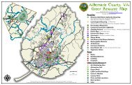
Staff has prepared maps showing the proposed designation of Preserved and Managed slopes. These<br />
maps are available by clicking here.<br />
Under the proposed ordinance areas designated as preserved slopes may not be disturbed except for<br />
certain permitted activities. Permitted by right activities include: Construction of the first dwelling on an<br />
existing lot if no other area is available, expansion of existing structures, establishment of public facilities<br />
necessary to use the property provided that development criteria is met, establish of biking and<br />
pedestrian trails, establishment of accessory uses to existing dwellings. Permitted activities by special
use permit include the establishment of private facilities necessary to the use of the property.<br />
Disturbing managed slopes would be permitted provided that design standards are met. The design<br />
standards are intended to allow use of steep areas without the use of excessively tall retaining walls,<br />
minimizing runoff and siltation from newly constructed slopes, maintaining visual quality and minimizing<br />
impacts on abutting properties.<br />
The proposed ordinance does not:<br />
1. Increase or decrease the areas regulated.<br />
2. Reduce environmental protection.<br />
3. Increase costs to applicants or the <strong>County</strong>.<br />
Benefits of the proposed ordinance:<br />
FAQs<br />
1. Predictability. All parties will know which areas may be disturbed and which may not.<br />
2. Establishes design standards to insure that the <strong>County</strong>’s resources are protected. These<br />
resources include protection of water resources and scenic resources.<br />
3. Allows for efficient use of designated development areas potentially decreasing the need to<br />
expand the development areas.<br />
4. Saves the taxpayers of the <strong>County</strong> approximately $24,000 to $56,000 a year in estimated cost<br />
associated with the processing of special exception requests. (These figures are based on<br />
historical costs between 2005 and 2012 associated with the processing of special exceptions.)<br />
5. Allows existing residential lots to expand use their property without first applying for a special<br />
exception. It must be reinforced that special exceptions are discretionary and approval is not<br />
guaranteed.<br />
6. Establishes criteria for determination of exempt activities.<br />
- How do I tell how much of my property is affected by <strong>Critical</strong> <strong>Slopes</strong><br />
- How do I determine if the slopes are proposed to be designated as Preserved or Managed<br />
- Will I be able to build an addition to my house<br />
- Will I be able to build a house on a vacant residential lot<br />
- Will I be able to build a shed on my property<br />
- Can I grade my property to put in terraces<br />
- How can Preserved slopes be disturbed<br />
- Will the proposed ordinance affect my ability to subdivide<br />
- Does the proposed ordinance increase the areas subject to regulation<br />
- How can I request that slopes be designated as Managed instead of Preserved<br />
- How can I request that slopes be designated as Preserved instead of Managed<br />
- How can I remove slopes from being designated as either Managed or Preserved<br />
- What impact does the proposed amendment have on previously approved projects<br />
- What happens to newly created steep slopes<br />
- What happens when field run topography indicates slopes are different from the <strong>County</strong>’s<br />
mapping
- How do I tell how much of my property is affected by <strong>Critical</strong> <strong>Slopes</strong><br />
o <strong>Critical</strong> <strong>Slopes</strong> on every parcel are mapped in the <strong>County</strong>’s GIS system.<br />
http://gisweb.albemarle.org/GISWeb/Welcome.aspx<br />
By entering your address you will be able view your property. If your property has not<br />
been addressed you can enter the owners name or the Tax Map and Parcel number.<br />
Once the parcel has been found, select “<strong>Critical</strong> Resource Plan”. The critical slopes on<br />
the property will be shaded.<br />
- How do I determine if the slopes are proposed to be designated as Preserved or Managed<br />
o Staff has prepared maps showing the proposed designations. These maps may be found<br />
by clicking the link below:<br />
• Crozet<br />
• Hollymead<br />
• Neighborhoods 1-2<br />
• Neighborhoods 4-7<br />
• Pantops<br />
• Piney Mountain<br />
• Rivanna<br />
- Will I be able to build an addition to my house<br />
o The staff proposal is that additions will be permitted in both Preserved and Managed<br />
areas. The design standards for the resulting grading will need to be followed.<br />
Back to FAQs<br />
- Will I be able to build a house on a vacant residential lot<br />
o The staff proposal is that no residential lot will be rendered unbuildable due to the<br />
changes in the ordinance. If area is available outside of Preserved or Managed slopes<br />
for the construction of the house that area must be used. If no area is available outside<br />
of Preserved or Managed <strong>Slopes</strong> then those areas may be used.<br />
- Will I be able to build a shed on my property<br />
o The staff proposal is that sheds will be permitted in both Preserved and Managed areas.<br />
The design standards for the resulting grading will need to be followed.<br />
- Can I grade my property to put in terraces<br />
o The staff proposal is that grading for terraces will be permitted in both Preserved and<br />
Managed areas. The design standards for the resulting grading will need to be followed.<br />
- How can Preserved slopes be disturbed<br />
o The staff proposal includes some exempt activities that may occur on Preserved slopes<br />
provided that standards are met. These activities include things such as utilities and<br />
trails. Any proposal for a non-exempt activity would not be permitted unless the Board<br />
of Zoning Appeals grants a variance based on hardship.<br />
- Will the proposed ordinance affect my ability to subdivide<br />
o The proposed ordinance has no impact on subdivision beyond the existing regulations.<br />
Back to FAQs
- Does the proposed ordinance increase the areas subject to regulation<br />
o No. It also does not decrease the areas subject to regulation.<br />
- How can I request that slopes be designated as Managed instead of Preserved<br />
o Prior to adoption of the ordinance you can contact staff and make a request. You are<br />
also encouraged to speak at the Planning Commission and Board of Supervisors public<br />
hearings. After adoption of the ordinance the property owner may file a rezoning<br />
request which will be heard by the Planning Commission and Board of Supervisors.<br />
- How can I request that slopes be designated as Preserved instead of Managed<br />
o Prior to adoption of the ordinance you can contact staff and make a request. You are<br />
also encouraged to speak at the Planning Commission and Board of Supervisors public<br />
hearings. After adoption of the ordinance the property owner may file a rezoning<br />
request which will be heard by the Planning Commission and Board of Supervisors.<br />
Back to FAQs<br />
- How can I remove slopes from being designated as either Managed or Preserved<br />
o Prior to adoption of the ordinance you can contact staff and make a request. You are<br />
also encouraged to speak at the Planning Commission and Board of Supervisors public<br />
hearings. After adoption of the ordinance the property owner may file a rezoning<br />
request which will be heard by the Planning Commission and Board of Supervisors.<br />
- What impact does the proposed amendment have on previously approved projects<br />
o Approved Site Plans and Subdivisions plats are not impacted by any change in the<br />
Zoning <strong>Ordinance</strong> for as long as the Site Plan or Subdivision approval remains valid.<br />
- What happens to newly created steep slopes<br />
o When grading results in new slopes of 25% or greater they will be subject to the critical<br />
slopes regulations that currently exist.<br />
- What happens when field run topography indicates slopes are different from the <strong>County</strong>’s<br />
mapping<br />
o The standard now, and proposed in this text amendment, is to use the <strong>County</strong> mapping<br />
as the default for determining the location of steep slopes. Under the current<br />
regulations if an applicant performs field run topography that shows the slope is less<br />
than 25%, the <strong>County</strong> accepts that information and the critical slope regulations<br />
automatically do not apply. Under the proposed regulations the slopes would still be<br />
protected unless the applicant submits a rezoning and the rezoning is approved by the<br />
Board of Supervisors.<br />
Back to FAQs
Draft <strong>Proposed</strong> <strong>Ordinance</strong> – 7/10/13<br />
3.1 Definitions<br />
<strong>Critical</strong> slopes: <strong>Slopes</strong> other than managed slopes or preserved slopes of twenty-five (25) percent or<br />
greater as determined by reference to either current topographic mapping available from the county or<br />
a more accurate field survey certified by a professional surveyor or engineer. <strong>Slopes</strong> of twenty-five (25)<br />
percent or greater created as the result of lawfully approved development shall not be considered<br />
critical slopes. (Added 7-11-12)<br />
Managed <strong>Slopes</strong>: The term Managed <strong>Slopes</strong> means any slope shown as a Managed Slope on a map<br />
adopted by the <strong>Albemarle</strong> <strong>County</strong> Board of Supervisors.<br />
Preserved <strong>Slopes</strong>: The term Preserved <strong>Slopes</strong> means any slope shown as a Preserved Slope on a map<br />
adopted by the <strong>Albemarle</strong> <strong>County</strong> Board of Supervisors.<br />
<strong>Critical</strong> <strong>Slopes</strong> Overlay District<br />
30.7.1 Purpose and Intent<br />
• The purpose of this section is to establish as an overlay district property within the development<br />
areas of <strong>Albemarle</strong> <strong>County</strong> which have steep slopes and for which additional development<br />
design care and consideration must be given, prior to the development occurring. The intent of<br />
this district is also to establish development design standards, which will protect the integrity of<br />
the steep slope areas, resulting in development, which will enhance and preserve the character<br />
and beauty of the steep slope areas of the county. This section recognizes that not all steep<br />
slopes have the same limitations for development. Therefore, two categories of steep slopes<br />
are established; Preserved and Managed:<br />
• Preserved slopes are those slopes that have characteristics that warrant their<br />
preservation by the prohibition of disturbance except in the limited circumstances set<br />
out in this ordinance. The characteristics of Preserved slopes are:<br />
• The slopes are a contiguous area of 10,000 square feet or more or a close<br />
grouping of slopes less than 10,000 square feet.<br />
• The slopes are part of a system of slopes associated with a water feature.<br />
• The slopes are part of a hillside system.<br />
• The slopes are identified as a resource in the Open Space Plan.<br />
• The slopes are identified as a resource in the Comprehensive Plan.<br />
• The slopes may be of significant value to the Entrance Corridor District.<br />
• The slopes are shown to be preserved by a prior <strong>County</strong> action.
30.7.2 Permitted Uses<br />
• Managed <strong>Slopes</strong> are those where development may occur provided that design<br />
standards are met to mitigate the impacts caused by the disturbance of the slopes. The<br />
characteristics of Managed <strong>Slopes</strong> are:<br />
• The contiguous area of critical slopes is limited or fragmented.<br />
• The slopes are not associated with a water feature.<br />
• The slopes are not natural.<br />
• The slopes have been significantly disturbed prior to June 1, 2012.<br />
• The slopes are located within previously approved single family residential lots.<br />
• The slopes are shown to be disturbed by a prior <strong>County</strong> action.<br />
a. Managed <strong>Slopes</strong><br />
1. Uses permitted by right in the underlying zoning district shall be permitted by<br />
right in the <strong>Critical</strong> <strong>Slopes</strong> overlay district provided that the disturbance to<br />
establish such use complies with the <strong>County</strong> Code and the design standards<br />
contained in 30.7.3.<br />
2. Any lot or parcel of record which was lawfully a lot of record on DATE OF<br />
ADOPTION may establish the first single-family detached dwelling unit on such<br />
lot or parcel; provided the parcel does not contain adequate land area outside<br />
of managed slopes for the location of such structure. For the purposes of this<br />
section, the term "lawfully a lot of record" shall also apply to any lot shown on a<br />
subdivision plat approved prior to DATE OF ADOPTION, provided such plat has<br />
not expired. Any disturbance to establish the first single-family detached<br />
dwelling shall comply with the design standards contained in 30.7.3.<br />
b. Preserved <strong>Slopes</strong><br />
1. The following uses are permitted by right on Preserved <strong>Slopes</strong> provided that the<br />
disturbance complies with the <strong>County</strong> Code and the design standards contained<br />
in 30.7.3.<br />
i. Any structure which was lawfully in existence prior to DATE OF<br />
ADOPTION may be expanded, enlarged, extended, modified and/or<br />
reconstructed. For the purposes of this section, the term "lawfully in<br />
existence" shall also apply to any structure for which a site development<br />
plan was approved or a building permit was issued prior to DATE OF<br />
ADOPTION, provided such plan or permit has not expired.
ii. Any lot or parcel of record which was lawfully a lot of record on DATE<br />
OF ADOPTION may establish the first single-family detached dwelling<br />
unit on such lot or parcel; provided the parcel does not contain<br />
adequate land area in outside of preserved slopes for the location of<br />
such structure. For the purposes of this section, the term "lawfully a lot<br />
of record" shall also apply to any lot shown on a subdivision plat<br />
approved prior to DATE OF ADOPTION, provided such plat has not<br />
expired.<br />
iii. Public facilities necessary to allow the use of the parcel provided that<br />
any of the following factors apply:<br />
1. The disturbance avoids impacts on other protected resources<br />
such as stream buffers or floodplain.<br />
2. The alignment is consistent with facilities included in the<br />
Comprehensive Plan.<br />
3. The disturbance is necessary to provide interconnection<br />
required by the <strong>County</strong> Code or the regulations of other<br />
agencies.<br />
4. Literal enforcement of the provision will result in unnecessary<br />
hardship.<br />
5. The exceptional narrowness, shallowness, size or shape of a<br />
specific piece of property at the time of the effective date of<br />
this ordinance, the strict application of the terms of this<br />
ordinance would effectively prohibit or unreasonably restrict<br />
the use of the property.<br />
iv. Public or Private pedestrian and cycling trails.<br />
v. Accessory uses to dwellings lawfully in existence prior to DATE OF<br />
ADOPTION.<br />
2. The following uses shall be permitted by special use permit.<br />
a. Private facilities such as accesways, utility lines and appurtenances and<br />
stormwater management facilities necessary to allow the use of the parcel
30.7.3 Design Standards<br />
a. The maximum height for a single retaining wall, measured from grade to grade, shall be 6<br />
feet. When the overall retained height would exceed 6 feet, the retaining wall shall be<br />
broken into multiple stepped walls.<br />
1. A minimum horizontal distance of 3 feet shall be maintained between each<br />
individual wall in the stepped wall system, and shall be landscaped with screening<br />
shrubs planted on 10 foot centers.<br />
2. Retaining walls may be incorporated into the design of a structure so that they<br />
become part of the structure. Retaining walls incorporated into the design of a<br />
structure shall not be subject to limitations in height.<br />
b. Cuts and fills shall be rounded off to eliminate sharp angles at the top, bottom and side of<br />
regraded slopes.<br />
c. The toe of the fill slope shall not be located within 10 feet horizontally of the top of an<br />
existing or proposed cut slope.<br />
d. Tops and bottoms of cut and fill slopes shall be set back from existing and proposed<br />
property lines a distance at least equal to the lesser of three feet plus 1/5 of the height of<br />
the cut or fill, or 10 feet.<br />
e. Cut and fill slopes shall not be steeper than 2:1 (fifty (50) percent). Where the slope is to be<br />
mowed, the slope shall be no steeper than 3:1 (thirty three (33) percent.<br />
f. Reverse slope benches or diversion shall be provided whenever the vertical interval (height)<br />
of any 2:1 (fifty (50) percent) slope exceeds 20 feet; for 3:1 (thirty three (33) percent) slope<br />
it shall be increased to 30 feet and for 4:1 (twenty- five (25) percent) to 40 feet.<br />
1. Benches shall be located to divide the slope face as equally as possible and shall<br />
convey the water to a stable outlet.<br />
2. Benches shall be a minimum of six feet wide to provide.<br />
3. Benches shall be designed with a reverse slope of 6:1 (seventeen (17) percent) or<br />
flatter to the toe of the upper slope and with a minimum of one foot in depth.<br />
Bench gradient to the outlet shall be between 2 percent and 3 percent, unless<br />
accompanied by appropriate design and computations.<br />
4. The flow length within a bench shall not exceed 800 feet unless accompanied by<br />
appropriate design and computations.<br />
g. Surface water shall be diverted from the face of all cut and/or fill slopes by the use of<br />
diversions, ditches and swales or conveyed downslope by the use of a designed structure.<br />
The face of the slope shall not be subject to any concentrated flows of surface water such as<br />
from natural drainage ways, graded swales, downspouts, etc.
h. Subsurface drainage shall be provided where deemed necessary by the <strong>County</strong> Engineer to<br />
intercept seepage that would otherwise adversely affect slope stability or create excessively<br />
wet site conditions.<br />
30.7.6 Amendment of <strong>Critical</strong> <strong>Slopes</strong> Overlay District<br />
a. The delineation of the critical slopes overlay district may be revised, amended and modified by<br />
the board of supervisors after application is made by the owner in accord with the provisions of<br />
section 33 provided that the application includes field run topography prepared by a licensed<br />
engineer, surveyor or landscape architect indicating that the area does not include slopes of<br />
25% or greater. or,<br />
b. The delineation of the critical slopes overlay district may be revised, amended and modified by<br />
the board of supervisors after application is made by the owner in accord with the provisions of<br />
section 33.<br />
35.1 FEES.<br />
Each applicant shall pay the following applicable fees, provided that neither the county nor the county<br />
school board shall be required to pay any fee if it is the applicant:<br />
b. Zoning map amendments:<br />
1. Less than 50 acres; application and first resubmission: $2500.00<br />
2. Less than 50 acres; each additional resubmission: $1250.00<br />
3. 50 acres or greater; application and first resubmission: $3500.00<br />
4. 50 acres or greater; each additional resubmission: $1750.00<br />
5. Deferral of scheduled public hearing at applicant’s request: $180.00<br />
6. No fee shall be required for applications submitted in accord with section 30.7.6(a).<br />
j. Required notice:<br />
1. Preparing and mailing or delivering up to fifty (50) notices: $200.00, except for uses under sections<br />
5.1.47 and 5.2A, or applications submitted in accord with section 30.7.6(a), for which there shall be no<br />
fee.<br />
2. Preparing and mailing or delivering, per notice more than fifty (50): $1.00 plus the actual cost of first<br />
class postage. No fee shall be required for applications submitted in accord with section 30.7.6(a)<br />
3. Published notice: cost based on a cost quote from the publisher, except for farmers’ markets under<br />
section 35.1(c) (7) and (8) or applications submitted in accord with section 30.7.6(a) for which there shall<br />
be no fee.