
Create successful ePaper yourself
Turn your PDF publications into a flip-book with our unique Google optimized e-Paper software.
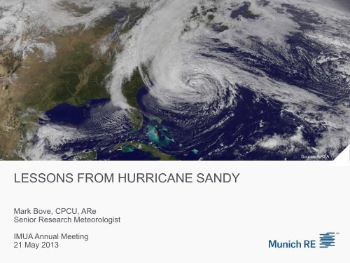
Source: NASA<br />
<strong>LESSONS</strong> <strong>FROM</strong> <strong>HURRICANE</strong> <strong>SANDY</strong><br />
Mark Bove, CPCU, ARe<br />
Senior Research Meteorologist<br />
<strong>IMUA</strong> Annual Meeting<br />
21 May 2013
Agenda<br />
• Hurricane Sandy<br />
• Storm History<br />
• Why did Sandy become a “Superstorm”<br />
• Storm Impacts<br />
• Wind<br />
• Precipitation<br />
• Storm Surge<br />
• Underwriting & Catastrophe Modeling Lessons<br />
• Application of Hurricane Deductibles<br />
• Accuracy of Surge Modeling<br />
• Flood Exposure Data<br />
• Location of Contents<br />
• Marine Exposures
Hurricane Sandy<br />
Source: NASA
Source: NASA<br />
Source: NASA<br />
Storm History: Hurricane Sandy<br />
• October 22: Tropical<br />
Depression #18 is classified<br />
in the south-central<br />
Caribbean Sea. The<br />
depression is upgraded later<br />
that day, becoming Tropical<br />
Storm Sandy, as it moved<br />
slowly northward.<br />
• October 24: Sandy begins a<br />
period of rapid intensification.<br />
Becomes Cat 1 hurricane<br />
before landfall in eastern<br />
Jamaica, then Cat 3 before<br />
landfall over eastern Cuba.
Source: NASA<br />
Source: NASA<br />
Storm History: Hurricane Sandy<br />
• October 25-26: Sandy exits<br />
Cuba, then passes over the<br />
eastern Bahamas. Weakens<br />
back into Tropical Storm due<br />
to wind shear but storm size<br />
increases dramatically.<br />
• October 27-28: Sandy moves<br />
northeastward, hundreds of<br />
miles off the Carolina coast.<br />
Sandy regains hurricane<br />
intensity.
Source: NASA<br />
Storm History: Hurricane Sandy<br />
• October 29: Sandy turns<br />
northward, then northwest.<br />
Reaches a secondary<br />
maximum intensity of 85 kts<br />
(100 mph). Forward motion<br />
also accelerates as storm<br />
moves towards the coast. Wind<br />
field continues to expand.<br />
• Once over colder water, Sandy<br />
starts to lose tropical<br />
characteristics, becoming<br />
“post-tropical” just before<br />
landfall near Atlantic City, NJ.
Title of presentation and name of speaker<br />
6/13/2013<br />
Source: NOAA<br />
7
Title of presentation and name of speaker<br />
6/13/2013 8
Hurricanes off the New Jersey Coastline, 1851 - 2011<br />
Sandy’s Path<br />
Title of presentation and name of speaker<br />
6/13/2013 9<br />
Source: NOAA
Why did Sandy Become a “Superstorm”<br />
• At landfall in New Jersey, Sandy possess some unusual path, size, and<br />
hazard characteristics, leading the storm to be dubbed a “Superstorm”<br />
by the media, including:<br />
• West-northwestward motion into New Jersey coast<br />
• Very large wind field<br />
• Extreme storm surge in New York & New Jersey<br />
• The term “Superstorm” is a creation of the media. There is no formal<br />
meteorological meaning for this term.<br />
• In meteorological terms, Hurricane Sandy completed a process known<br />
as Extratropical Transition just before landfall. This resulted in the<br />
National Hurricane Center classifying Sandy as “Post-Tropical”, which<br />
means Sandy had become an extratropical cyclone.
Source: NASA<br />
Source: NASA<br />
Understanding Extratropical Transition:<br />
Types of Large-Scale Storms<br />
Tropical Cyclones<br />
• Low pressure center warmer than<br />
surroundings (Warm-Core Low).<br />
• Develop in air masses of relatively<br />
constant temperature and humidity.<br />
• Symmetrical shape.<br />
• Weak upper-level winds aloft.<br />
Extratropical Cyclones<br />
• Low pressure center colder than<br />
surroundings (Cold-Core Low).<br />
• Develop in areas of temperature<br />
gradients between differing air masses.<br />
• Asymmetrical Shape<br />
• Strong upper-level winds critical in<br />
development and intensification.
Source: NASA<br />
Source: NASA<br />
Understanding Extratropical Transition<br />
• Process of tropical cyclone becoming an extratropical (frontal) cyclone.<br />
Usually induced when hurricanes interact with colder, drier air, jet<br />
streams, or extratropical weather systems.<br />
Floyd as Tropical Low<br />
Floyd as Transitioning Low
Source: NOAA/NCEP<br />
Title of presentation and name of speaker<br />
6/13/2013 13
Title of presentation and name of speaker<br />
6/13/2013 14
Source: NASA<br />
Title of presentation and name of speaker<br />
6/13/2013 15
Sea Surface Temperatures, Late October 2012<br />
Source: NOAA<br />
Title of presentation and name of speaker<br />
6/13/2013 16
Source: NOAA
Why did Sandy turn West<br />
Source: NOAA<br />
Title of presentation and name of speaker<br />
6/13/2013 18
Why did Sandy have such a large windfield<br />
Why was the storm surge so extreme<br />
Source: NOAA
Source: Munich Re<br />
Sandy Impacts
Sandy Impacts - Overview<br />
• Second largest insured loss in the United States due to a tropical cyclone<br />
in terms of original dollar loss, $30 bn. (First: Katrina (2005), $60 bn)<br />
• Estimated economic losses of $65 bn.<br />
• Most damaging tropical cyclone in the Northeastern United States since<br />
the 1938 Great New England Hurricane.<br />
• Wind damage observed across 15 states & Canadian Maritime provinces<br />
• Record storm surges along New York and New Jersey Coastlines<br />
causing extensive damage.<br />
• Power outages widespread across the region due to both wind and<br />
surge.<br />
• Major infrastructure damage in New York City.
Hurricane Sandy<br />
Maximum 1-Minute Sustained Winds & Gusts<br />
Source: NOAA<br />
Title of presentation and name of speaker<br />
6/13/2013 22
Examples of Sandy Wind Damage<br />
Source: Munich Re<br />
Title of presentation and name of speaker<br />
6/13/2013 23
Examples of Sandy Wind Damage<br />
Source: Munich Re<br />
Title of presentation and name of speaker<br />
6/13/2013 24
Hurricane Sandy<br />
Rainfall Totals<br />
Source: NOAA<br />
Title of presentation and name of speaker<br />
6/13/2013 25
Hurricane Sandy<br />
Snowfall Totals<br />
Source: NOAA<br />
Title of presentation and name of speaker<br />
6/13/2013 26
Hurricane Sandy<br />
Storm Surge (Height above ground level)<br />
Source: NOAA<br />
Title of presentation and name of speaker<br />
6/13/2013 27
Hurricane Sandy<br />
Storm Surge Damage, Mantoloking, NJ<br />
Source: NOAA
Hurricane Sandy<br />
Storm Surge Damage<br />
Title of presentation and name of speaker<br />
6/13/2013 29
Hurricane Sandy<br />
Storm Surge Damage<br />
Source: Munich Re<br />
Title of presentation and name of speaker<br />
6/13/2013 30
Hurricane Sandy<br />
Storm Surge Damage<br />
Source: Munich Re<br />
Title of presentation and name of speaker<br />
6/13/2013 31
Underwriting and Cat Modeling Lessons From Sandy<br />
Source: Carl Hedde / Used with Permission
Lessons from Sandy:<br />
Hurricane Deductibles<br />
• Designed to reduce insurance costs for consumers by requiring a higher<br />
deductible for rare, but extreme loss events, like hurricanes.<br />
• Each state can independently define how a hurricane deductible is<br />
triggered in their state.<br />
• “Named Storm” – Any storm named by the National Hurricane<br />
Center<br />
• Hurricane – Any storm classified as a hurricane at landfall by the<br />
National Hurricane Center<br />
• Variations: Only Cat 2 & Above, etc.<br />
• Storm must make direct landfall over the state.
Lessons from Sandy:<br />
Hurricane Deductibles<br />
Source: State of New Jersey
Lessons from Sandy:<br />
Hurricane Deductibles<br />
• For two consecutive years, borderline-hurricane events have made<br />
landfall in the northeast, but hurricane deductibles haven’t been allowed to<br />
be applied.<br />
• This means that the modeling assumption of using a hurricane<br />
deductible for weak Cat 1 hurricanes or transitioning storms may be<br />
incorrect.<br />
• This practice artificially reduces the loss costs for portfolios because<br />
the fire deductible isn’t used in the modeling.<br />
• Currently, some models typically only accept one deductible type per peril.<br />
• Do we ask for wind and fire deductibles in data submissions<br />
• For which storms in the event set should the fire deductible be used<br />
with
Lessons from Sandy:<br />
Storm Surge Modeling<br />
Surge is only partially<br />
dependent on storm<br />
intensity. Do the models<br />
reflect that large surges<br />
can be generated by<br />
weaker hurricanes or<br />
storms undergoing<br />
transition<br />
Flooded areas in New York<br />
by hurricane category<br />
(SSHS)<br />
Category 1<br />
Category 2<br />
Category 3<br />
Category 4<br />
Source: Munich Re – Severe weather in North America, 2012
Lessons from Sandy:<br />
Flood Exposure Data<br />
• There are no statistical inland flood models available for the United<br />
States (coastal surge modeling exists), largely due to the fact that most<br />
flood risks in the US are federally insured via the NFIP.<br />
• Historically, there has been low demand by model clients to develop<br />
these models.<br />
• Developing an inland flood model would be a huge project, taking<br />
modeling companies years to develop.<br />
• As a result, the capturing of data for privately-insured flood risks in the<br />
industry significantly lags data capture for other perils.<br />
• Current modeling of flood risks for surge, when known, is also limited by<br />
ability of models to handle flood sublimits and accurately determine<br />
amount of flood damage that “leaks” into the wind policy claim.
Lessons from Sandy:<br />
Location of Contents<br />
• The location of contents within an insured location is critical when<br />
assessing flood loss potential, particularly for commercial and industrial<br />
risks.<br />
• Examples:<br />
• Hospitals (MRIs, CAT Scan Machines, Radiology equipment)<br />
• Office Buildings (Electrical and IT equipment, etc.)<br />
• Specialty businesses (Art Galleries)<br />
• Models tend to spread out contents value over the number of stories<br />
within a building. This could lead to an underestimation of the amount of<br />
contents at risk to flood losses.
Lessons from Sandy:<br />
Impact to Marine Industry<br />
• Inland/Ocean Accumulation Risks<br />
• Ports and stevedore operations exposed to significant storm surge<br />
• Chelsea art district flood and storm surge exposure<br />
• Are cargo/transit policy occurrence limits adequate<br />
• Warehouses<br />
• Flood maps are inaccurate – location and aggregation issues<br />
• How cargo is stored matters<br />
• Yachts & Marinas<br />
• Haul-outs caused more damage than proper mooring in place<br />
• Pilings too short<br />
• Correct insurance to value - cost to rebuild to code may be significant
Source: NASA<br />
THANK YOU! ANY QUESTIONS<br />
Mark Bove<br />
mbove@munichreamerica.com
© Copyright 2013 Munich Reinsurance America, Inc. All rights reserved. "Munich Re" and the Munich Re logo are<br />
internationally protected registered trademarks. The material in this presentation is provided for your information only, and<br />
is not permitted to be further distributed without the express written permission of Munich Reinsurance America, Inc. or<br />
Munich Re. This material is not intended to be legal, underwriting, financial, or any other type of professional advice.<br />
Examples given are for illustrative purposes only. Each reader should consult an attorney and other appropriate advisors<br />
to determine the applicability of any particular contract language to the reader's specific circumstances.<br />
Source: NASA