March/April 2013 - City of Golden Valley
March/April 2013 - City of Golden Valley
March/April 2013 - City of Golden Valley

Create successful ePaper yourself
Turn your PDF publications into a flip-book with our unique Google optimized e-Paper software.
!<br />
!<br />
!<br />
!<br />
!<br />
!<br />
!<br />
!<br />
!<br />
!<br />
Val<br />
l<br />
eywood Cir<br />
ossroad S<br />
Lawn Ter<br />
!<br />
!<br />
!<br />
!<br />
!<br />
!<br />
s<br />
Westwood D<br />
PUBLIC WORKS<br />
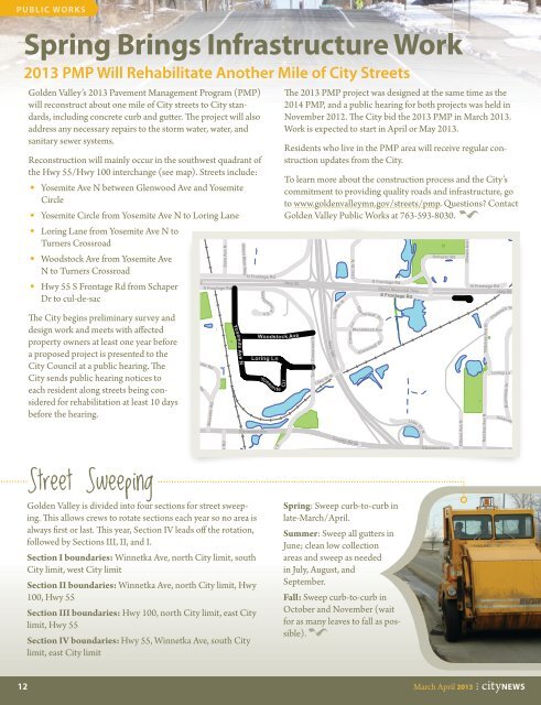
Spring Brings Infrastructure Work<br />
<strong>2013</strong> PMP Will Rehabilitate Another Mile <strong>of</strong> <strong>City</strong> Streets<br />
<strong>Golden</strong> <strong>Valley</strong>’s <strong>2013</strong> Pavement Management Program (PMP)<br />
will reconstruct about one mile <strong>of</strong> <strong>City</strong> streets to <strong>City</strong> standards,<br />
including concrete curb and gutter. The project will also<br />
address any necessary repairs to the storm water, water, and<br />
sanitary sewer systems.<br />
Reconstruction will mainly occur in the southwest quadrant <strong>of</strong><br />
the Hwy 55/Hwy 100 interchange (see map). Streets include:<br />
• Yosemite Ave N between Glenwood Ave and Yosemite<br />
Circle<br />
• Yosemite Circle from Yosemite Ave N to Loring Lane<br />
• Loring Lane from Yosemite Ave N to<br />
Turners Crossroad<br />
• Woodstock Ave from Yosemite Ave<br />
N to Turners Crossroad<br />
• Hwy 55 S Frontage Rd from Schaper<br />
S Frontage Rd<br />
Dr to cul-de-sac<br />
The <strong>City</strong> begins preliminary survey and<br />
design work and meets with affected<br />
property owners at least one year before<br />
a proposed project is presented to the<br />
<strong>City</strong> Council at a public hearing. The<br />
<strong>City</strong> sends public hearing notices to<br />
each resident along streets being considered<br />
for rehabilitation at least 10 days<br />
before the hearing.<br />
Street Sweeping<br />
morial Hwy<br />
<strong>Golden</strong> <strong>Valley</strong> is divided into four sections for street sweeping.<br />
This allows crews to rotate sections each year so no area is<br />
always first or last. This year, Section IV leads <strong>of</strong>f the rotation,<br />
followed by Sections III, II, and I.<br />
Section I boundaries: Winnetka Ave, north <strong>City</strong> limit, south<br />
<strong>City</strong> limit, west <strong>City</strong> limit<br />
Section II boundaries: Winnetka Ave, north <strong>City</strong> limit, Hwy<br />
100, Hwy 55<br />
Section III boundaries: Hwy 100, north <strong>City</strong> limit, east <strong>City</strong><br />
limit, Hwy 55<br />
Section IV boundaries: Hwy 55, Winnetka Ave, south <strong>City</strong><br />
limit, east <strong>City</strong> limit<br />
Brunswick<br />
Ave N<br />
Meander Rd<br />
Cutacross Rd<br />
King Hill Rd<br />
Meander Rd<br />
Zane Ave N<br />
Creek Rd<br />
King<br />
Yosemite Ave N<br />
Olson Mem Hwy<br />
N Frontage Rd<br />
Woodstock Ave<br />
Loring Ln<br />
Yosem<br />
Glenwood Ave<br />
i te<br />
Xenia Ave S<br />
The <strong>2013</strong> PMP project was designed at the same time as the<br />
2014 PMP, and a public hearing for both projects was held in<br />
November 2012. The <strong>City</strong> bid the <strong>2013</strong> PMP in <strong>March</strong> <strong>2013</strong>.<br />
Work is expected to start in <strong>April</strong> or May <strong>2013</strong>.<br />
Residents who live in the PMP area will receive regular construction<br />
updates from the <strong>City</strong>.<br />
To learn more about the construction process and the <strong>City</strong>’s<br />
commitment to providing quality roads and infrastructure, go<br />
to www.goldenvalleymn.gov/streets/pmp. Questions Contact<br />
<strong>Golden</strong> <strong>Valley</strong> Public Works at 763-593-8030.<br />
Cir<br />
Hwy 55<br />
Lilac D<br />
Turners Crossroad N<br />
Hwy 100<br />
Lilac Dr N<br />
Turnpike Rd<br />
Lilac Dr N<br />
Woodstock Ave<br />
<strong>2013</strong> PMP Project Location Map<br />
Spring: Sweep curb-to-curb in<br />
late-<strong>March</strong>/<strong>April</strong>.<br />
Summer: Sweep all gutters in<br />
June; clean low collection<br />
areas and sweep as needed<br />
in July, August, and<br />
September.<br />
Olson Memorial Hwy<br />
Fall: Sweep curb-to-curb in<br />
October and November (wait<br />
for as many leaves to fall as possible).<br />
Lilac Dr N<br />
Ln<br />
Clover<br />
Clo<br />
County Rd 40<br />
v erleaf Dr<br />
r<br />
Cloverleaf D<br />
N Frontage Rd<br />
S Frontage Rd<br />
! !<br />
! !<br />
Lilac Dr N<br />
Hwy 100<br />
Schaper Rd<br />
Glenwood Ave<br />
Ottawa Ave N<br />
Ottawa Ave N<br />
Natchez Ave N<br />
Natchez Ave N<br />
Chatelain Ter<br />
Loring Ln<br />
Sources: Print Date: 4/19/2012<br />
-Hennepin County Surveyors Office<br />
for Property Lines (2011) and<br />
Aerial Photography (2009).<br />
Ottawa Ave S<br />
N Frontage Rd<br />
Hwy 55<br />
0 250<br />
500 1,000<br />
I<br />
Burntside Dr<br />
Roanoke R d<br />
Ma d dus L n<br />
Feet<br />
Count<br />
12 <strong>March</strong> <strong>April</strong> <strong>2013</strong> •