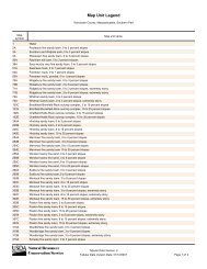
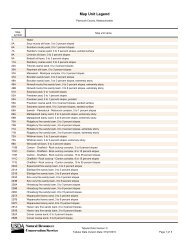
PLYMOUTH COUNTY SOIL SURVEY UPDDATE - NeSoil
PLYMOUTH COUNTY SOIL SURVEY UPDDATE - NeSoil
PLYMOUTH COUNTY SOIL SURVEY UPDDATE - NeSoil

You also want an ePaper? Increase the reach of your titles
YUMPU automatically turns print PDFs into web optimized ePapers that Google loves.
Plymouth County Soil Survey<br />
Update (Extensive Revision)<br />
It’s Done*!<br />
* Pending SSURGO certification, final correlation document signatures, and staging server operation
PCCD Soil Survey Assistance<br />
• Ground Penetrating Radar<br />
Investigations<br />
• Title V Workshops<br />
• Hydric Soil Workshops<br />
• Basic Soil Services<br />
• Soil Survey Contract Mapping<br />
• Soil Tunnel Educational Display
PCCD Update Mapping Contract<br />
• 39,002 acres mapped through this<br />
contract<br />
• ~ $1 / acre<br />
• 4 PCCD Contract mappers<br />
• Thank You!
Plymouth County Soil Survey<br />
• Size: 425,000 acres<br />
• MLRA’s: 149B &<br />
144A<br />
• Scale: 1:12,000<br />
• Minimum Size Delin.<br />
1/2 acre<br />
• 34,347 soil polygons<br />
• 7,993 Special spot<br />
features<br />
• 545 Special line<br />
features
What’s the Difference<br />
1969 Plymouth<br />
• Scale 1:15,840(MSD~2.5)<br />
• Gloucester Soil acreage =<br />
35,550<br />
• Field work 1950-1963<br />
• Sb = Sanded muck / bog<br />
• Urban areas unclassified<br />
• 106 mapunits<br />
2010 Plymouth<br />
• Scale 1:12,000(MSD~0.5)<br />
• Gloucester Soil Acres =<br />
2,875<br />
• Field work 1989-2009<br />
• Soil Series names on<br />
cranberry beds<br />
• Urban areas classified as<br />
high as possible to series<br />
• 6 New Soil Series, 9<br />
Dropped<br />
• Georeferenced sites
• Flown in<br />
Spring 1993<br />
(leaf off)<br />
• High<br />
Resolution<br />
• Un - rectified<br />
CIR<br />
• Increase<br />
Accuracy<br />
Field Mapping Imagery
1969 Field Mapping<br />
• Black & White 1952<br />
imagery
• Final Acre Ceremony (Who, What, Where,<br />
When, and Why)<br />
• Would like to request PCCD support along<br />
with Pilgrim RC&D<br />
• Website to support the Soil Data Mart and<br />
Web Soil Survey product<br />
• Thank you!
Title 5 - Soil Evaluator<br />
Workshops (PCCD)
Hydric Soil Workshops (PCCD)
Ground Penetrating Radar Soil<br />
Investigations<br />
Peat Mapping on Cranberry Beds
GPR - 2D - Peat Thickness