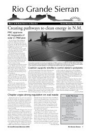
Choosing pollution Your photo - Rio Grande Chapter
Choosing pollution Your photo - Rio Grande Chapter
Choosing pollution Your photo - Rio Grande Chapter

You also want an ePaper? Increase the reach of your titles
YUMPU automatically turns print PDFs into web optimized ePapers that Google loves.
Creator of map of S.F. mountains dies<br />
By Janet Peacock<br />
Bill Drake, the author of the “Map of the<br />
Mountains of Santa Fe and the Pecos Vallley”<br />
and the founder of Drake Mountain Maps,<br />
died recently at his home in Santa Fe from leukemia.<br />
Bill was born in Wellington, New Zealand, in<br />
1941 and lived there until 1992, when he moved<br />
to Santa Fe to share his life with his new wife, Janet<br />
Peacock, a longtime Santa Fe resident and Sierra<br />
Club member.<br />
Bill began his mapping career in New Zealand<br />
when he was 18, taking a job with the Ministry<br />
of Lands and Surveys, which was responsible for<br />
producing maps of New Zealand. He worked there<br />
More Outings, continued from Page 16<br />
venture! Mt. Sneffles (14,156’) near<br />
Ouray – Strenuous, 8 miles, 3000’ gain,<br />
scramble up a packed scree field, a 600’<br />
boulder-filled couloir, crux move with<br />
exposure through a notch, and final<br />
scramble to the top. Royal Drews (505-<br />
699-8713).<br />
30 Moderate/Strenuous hike up the<br />
Big Tesuque to Tesuque peak (12,040’).<br />
6-7 miles, 2000-2300’ gain, some very<br />
steep sections. Early start time, limit<br />
of 10 people and 1-2 dogs. Miguel<br />
DeLuca (505- 820-0042).<br />
31 Moderate Hike in Jemez, limit of<br />
12. Norbert Sperlich (505-474-4354).<br />
31 Strenuous Hike to Pecos<br />
Baldy Lk with Trailrider’s Wall option,<br />
15 or 18 miles, 2,600 or 3,000’ gain, 1-2<br />
dogs. Robert Reifel (505- 984-1253).<br />
August<br />
6 Moderate hike on top of Sandia<br />
peak, 5 miles, 500’ gain. Limit of 10<br />
people, 1-2 dogs. Miguel DeLuca (505-<br />
820-0042).<br />
7 Very Strenuous Hike to Wheeler<br />
Peak, 13,161’. 11-14 miles, 4300’ gain,<br />
very early start, optional overnight Sat.<br />
Royal Drews (505- 699-8713).<br />
13-14 Strenuous 14er trip to San<br />
Luis Peak, 14014’ near Creede. Gradual<br />
and beautiful 10 miles on trail, 3,900’<br />
gain. Car-camp at Willow Ck trailhead<br />
for early start; high-clearance vehicles<br />
help. Mary Thompson (505-469-9499,<br />
mxtmary@yahoo.com).<br />
13 Moderate Hike to Puerto Nambe,<br />
8miles, 1200’ gain, 1-2 dogs, Les<br />
Drapela (505-438-3306)<br />
13 Moderate/strenuous hike to Santa<br />
Barbara Divide from Jicarita’s north<br />
T/H. 8miles, 2000’ gain, w/ possible Jicarita<br />
(12,835’) option for some. Alan<br />
Shapiro (505- 424-9242, Nm5s@<br />
yahoo.com).<br />
14 Strenuous Hike in Jemez to<br />
Los Griegos and Cerro Pelado. 12<br />
miles, 2700’ gain. Some steep, off-trail<br />
sections. Limit of 12, 2 dogs. Norbert<br />
Sperlich (505- 474-4354).<br />
20 Moderate hike on <strong>Rio</strong> En Medio<br />
(past waterfall) with optional dip<br />
in pool. 8miles, 1000’ gain, 1-2 dogs<br />
ok. Dan Rusthoi (505- 690-8967).<br />
21 Easy-Moderate Hike to East Fork,<br />
Jemez. 4 miles RT, 300’ gain. 30%<br />
of time in water between ankles and<br />
knees. Lunch on rocks near waterfall.<br />
Wear sandals, water shoes, or old<br />
sneakers, bring walking stick. Michael<br />
Goldey (505-820-7302, m.goldey@<br />
for more than 30 years, eventually becoming chief<br />
of topographical mapping for the country. He was<br />
instrumental in designing the relief-shaded format<br />
of the maps that are still the standard for the New<br />
Zealand mountains and backcountry.<br />
When Bill moved to Santa Fe, he was disappointed<br />
that none of the local maps showed the topography<br />
using relief shading. Since he was interested in<br />
exploring the local mountains and surrounding areas,<br />
he decided to produce his own map of the area using<br />
the format he had developed in New Zealand.<br />
The map was hand-drawn and compiled without<br />
the use of digital technology, and Bill checked the accuracy<br />
of virtually all the trails, dirt roads, and other<br />
features by hiking and biking them himself.<br />
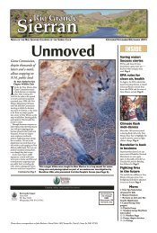
Outings participants on Hermit Peak in June.<br />
Santa River cleanup and vegetation maintenance<br />
9 to 11 a.m. July 16 and August 20<br />
Meet at the Closson Street Bridge where parking is available. Bring garden<br />
gloves and wear long pants. Leader will supply trash bags and gloves.<br />
Confirm prior to cleanup date to:<br />
July 16: Greg Lower (505-699-6893, glower@lanl.gov)<br />
August 20: Kathleen Davis (505- 795-3286, kdav40@gmail.com).<br />
mindspring.com).<br />
21 Moderate/Strenuous hike to<br />
Nambe Lake, 11,800’. 7 miles, 2100’<br />
gain. Some steep, rocky sections. Marcia<br />
Skillman (505- 699-3008, marciaskillman@hotmail.com).<br />
27 Moderate hike to Cerro <strong>Grande</strong><br />
Peak in Bandelier, 4 miles, 1300’ gain,<br />
great vistas at top. Norma McCallan<br />
(505-471-0005).<br />
28 Moderate Bike and hike.<br />
Bike from Terrero to Holy Ghost<br />
trailhead, 6 miles RT, 500’ gain. Then<br />
a 6 mile RT hike on lightly used trail<br />
with 1,000’ gain. 2-3 dogs trained to<br />
stay with biking owner OK. Page Press<br />
(505-946-0169).<br />
September<br />
3 Check website or weekly outings<br />
email for last-minute addition.<br />
3-4-5 Labor Day celebration up Telluride<br />
way with a climb of Wilson Peak,<br />
14,017’. Probably new Silver Pick/<br />
Rock of Ages trail to RoA saddle and<br />
then Class 3 scramble to the summit. 8<br />
miles, 3600’ gain, some exposure. See<br />
great beta on summitpost and 14ers.<br />
com. Royal Drews (505- 699-8713).<br />
3-4-5-6 Trail maintenance on<br />
Dominguez trail between Santa Barbara<br />
Cyn and Trampas Cyn in Pecos<br />
wilderness to remove deadfall on reconstructed<br />
sheepherder’s trail restored by<br />
Sierra Club two decades ago. Join us for<br />
some or all. Base camp 5 miles up West<br />
Fork Santa Barbara Ck. John Buchser<br />
(505-820-0201, jbuchser@comcast.net)<br />
4 Fun with fungi—Moderate hike,<br />
maybe toward La Vega, hoping for<br />
mushrooms. Up to 7miles, 1200’<br />
gain. Art Judd (505-982-3212).<br />
5 Strenuous loop hike to Penitente<br />
Lake and Deception Pks. 11+ miles,<br />
3100 ft. gain. Limit 12, 2 dogs. Dag<br />
Ryen (505-466-4063).<br />
10 Moderate/Strenuous hike on Tesuque<br />
Creek with loop back on Chamisa<br />
and Burn Trails 232 & 399, 9 miles,<br />
2000’ gain, 1-2 dogs ok. Dan Rusthoi<br />
(505- 690-8967).<br />
11 Strenuous hike to Cerro Pedernal<br />
near Abiquiu, 7miles, 1800’ gain,<br />
scramble to top. Marcia Skillman (505-<br />
699-3008, marciaskillman@hotmail.<br />
com).<br />
17 Moderate Hike on Apache<br />
Canyon Loop, 6.5 miles, 800’ gain, 1-2<br />
dogs. Dan Rusthoi (505- 690-8967).<br />
17 Strenuous Hike to Latir Wilderness<br />
near Questa, probably including<br />
Venado Pk., 15-17-mile loop,<br />
3500-3700’ gain, 10-12 hours hiking,<br />
optional car camp or motel Fri. night<br />
The first edition of the “Map of the Mountains of<br />
Santa Fe” was published in 1995. It was revised and<br />
expanded several times, with the final edition being<br />
produced in 2001.<br />
In 2009, Bill decided to retire from the mapping<br />
business, and the last copies of the map were sold to<br />
local Santa Fe shops.<br />
In addition to the Santa Fe map, Bill produced<br />
three maps of areas in Colorado —“Map of the<br />
Mountains of Silverton, Telluride & Ouray,” “Map<br />
of the Mountains between Silverton and Durango”<br />
and “Map of the Mountains of Telluride.” The first<br />
two of the Colorado maps are still being reprinted<br />
and sold by a company that bought the printing<br />
rights for these maps from Drake Mountain Maps.<br />
Photo by Larry Saine<br />
or very early start. High clearance<br />
carpooling needed. 1-2 dogs. Robert<br />
Reifel (505- 984-1253).<br />
18 Moderate Hike to Deer Trap Mesa<br />
in Los Alamos 5 miles RT, 500’ gain.<br />
Stroll along a mesa top, narrow at times,<br />
great views. Some rock scrambling and<br />
minor climbing. Michael Goldey (505-<br />
820-7302, m.goldey@mindspring.com).<br />
18 Strenuous Hike from Holy<br />
Ghost to Stewart Lake, 13 miles, 2200<br />
ft; Daisy Levine (505-466-8338).<br />
24 Moderate hike in Penistaja Badlands,<br />
near Cuba, with guest leader<br />
Tom Petencin. Badlands topography,<br />
rimrock and petrified wood. 4- to<br />
6-mile offtrail loop to see petrified<br />
stumps and logs, mudstone hills. Nice<br />
overlooks from rim. Less than 500’ gain.<br />
Bring 2L of water. Carpooling via Bernalillo.<br />
Norma McCallan (505-471-0005).<br />
24 Strenuous hike up Jicarita Peak,<br />
12,835. 11 miles, 2900’ gain. Very early<br />
start time, 4-hr RT drive. Limit 10.<br />
Miguel DeLuca (505-820-0042).<br />
25 Moderate/Strenuous Hike in<br />
Jemez. 9 miles, 2000’ gain. Some steep<br />
off trail sections. Limit of 12. Norbert<br />
Sperlich (505- 474-4354).<br />
25 Strenuous hike to beautiful Trampas<br />
Lakes, 11 miles, 2450’ gain. Rochelle<br />
Gerratt (505- 795-3254).<br />
October<br />
1-2 Strenuous Hike to Ladrone Pk<br />
(9210’) from the east side. 3300’ gain,<br />
offtrail and tough, unforgettable. Camp<br />
or stay in Socorro Sat nite, Sun hike and<br />
drive back. Michael Di Rosa (w: 505-<br />
667-0095, h: 505-663-0648).<br />
2 Moderate/strenuous Hike from<br />
Apache Springs to Upper Frijoles to<br />
Ponderosa CG in Bandelier; 9+ miles,<br />
1000 ft. gain. Limit 12. Dag Ryen<br />
(505- 466-4063).<br />
Central Group<br />
September<br />
24 Badlands hike—Penistaja. Nice<br />
Badlands topography, rimrock, and petrified<br />
wood is exposed at the Southern<br />
edge of this questa. 4- to 6-mile loop, up<br />
to rim for nice overlooks. Less than 500’<br />
gain. Bring at least 2L of water. Northern<br />
Group’s Norma McCallan will co-lead.<br />
Tom Petencin, tompeten@msn.com,<br />
271-9928.<br />
July/August/September 2011 rio <strong>Grande</strong> Sierran 15