An application of minimum spanning trees to travel planning - Informit
An application of minimum spanning trees to travel planning - Informit
An application of minimum spanning trees to travel planning - Informit

You also want an ePaper? Increase the reach of your titles
YUMPU automatically turns print PDFs into web optimized ePapers that Google loves.
4<br />
Fitina et al., <strong>An</strong> <strong>application</strong> <strong>of</strong> <strong>minimum</strong> <strong>spanning</strong> <strong>trees</strong> <strong>to</strong> <strong>travel</strong> <strong>planning</strong><br />
Travel in Papua New Guinea<br />
Papua New Guinea is a country in the southwestern Pacific Ocean. The<br />
country's geography is diverse and, in places, extremely rugged. A spine <strong>of</strong><br />
mountains runs the length <strong>of</strong> the island <strong>of</strong> New Guinea, forming a populous<br />
highlands region. Dense rainforests can be found in the lowland and coastal<br />
areas. This terrain has made it difficult for the country <strong>to</strong> develop transportation<br />
infrastructure. In some areas, airplanes are the only mode <strong>of</strong> transport<br />
(Wikipedia, http://en.wikipedia.org/wiki/Papua_New_Guinea)<br />
Airlines<br />
Air Niugini is the national airline <strong>of</strong> Papua New Guinea. It operates flights<br />
from the capital city Port Moresby <strong>to</strong> at least 10 overseas destinations. Within<br />
Papua New Guinea it services all the major airports in the country. On any<br />
given day it operates between 50 <strong>to</strong> 70 flights between any two destinations<br />
(nodes). Bookings may be made in one <strong>of</strong> several Air Niugini <strong>of</strong>fices and<br />
agencies around the country and overseas. As well, <strong>travel</strong>ers can make<br />
bookings over the internet at the address http://www.airniugini.com.pg. On this<br />
website there are two interactive maps, a domestic version and an international<br />
version, which convey the same type <strong>of</strong> information.<br />
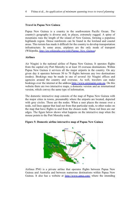
The domestic interactive map consists <strong>of</strong> the map <strong>of</strong> Papua New Guinea with<br />
the major cities in <strong>to</strong>wns, presumably where the airports are located, depicted<br />
with grey circles. These are the nodes. When a user places the mouse over a<br />
node, red lines appear that lead out from that particular node, <strong>to</strong> other nodes on<br />
the map that have flights <strong>to</strong> and from the chosen node. These red lines are our<br />
edges. The figure below shows what happens on the interactive map when the<br />
mouse points <strong>to</strong> the Port Moresby node.<br />
Figure 5: Domestic airline interactive map <strong>of</strong> Papua New Guinea<br />
Airlines PNG is a private airline that operates flights between Papua New<br />
Guinea and Australia and between numerous destinations within Papua New<br />
Guinea. It also has a website at http://www.apng.com/ where the intending