Drought Contingency Planning with Pastoral Communities - celep
Drought Contingency Planning with Pastoral Communities - celep
Drought Contingency Planning with Pastoral Communities - celep

You also want an ePaper? Increase the reach of your titles
YUMPU automatically turns print PDFs into web optimized ePapers that Google loves.
eing able to determine the nature and extent of risk by analyzing the characteristics of<br />
hazards, the degree of vulnerability and the capacity of the community.<br />
There are four main steps involved in<br />
participatory disaster risk assessment:<br />
1. Hazard Assessment<br />
2. Vulnerability Assessment<br />
3. Capacity Assessment<br />
4. Disaster Risk Analysis<br />
2.5.1 Hazard Assessment<br />
Hazard assessment identifies the most likely<br />
natural or man-made hazard or threat to<br />
the community, and seeks to understand its<br />
nature and behavior. In this case the focus<br />
of VSF is on drought hazard. But the nature<br />
and behavior of drought differs from place<br />
to place and we need to contextualize the<br />
International Strategy for Disaster Reduction (UN-<br />
ISDR) describes a hazard as “a potentially damaging<br />
physical event, phenomenon or human activity that<br />
may cause the loss of life or injury, property damage,<br />
social and economic disruption or environmental<br />
degradation.”<br />
Those based on nature: earthquakes, droughts,<br />
floods, avalanches, etc; those based on violence: war,<br />
armed conflict, physical assault, etc; those based on<br />
deterioration: declining health, education and other<br />
social services; environmental degradation, etc;<br />
those based on the failings of industrialized society:<br />
technological failures, oil spillage, factory explosions,<br />
fires, gas leakages, transport collisions. (Source:<br />
Bellers, 1999)<br />
hazard assessment. Many people refer to hazards as disasters. A hazard can only be called<br />
a disaster when it hits a community, and the effects are beyond that of the community’s<br />
coping ability.<br />
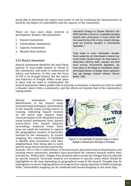
Hazard assessment involves:<br />
Identification of the hazard using<br />
brainstorming techniques, prioritization<br />
of the hazards using scoring matrix or<br />
ranking, Indicating hazard location<br />
on the social map (hazard map),<br />
characterization of the identified hazard<br />
using hazard assessment form, hazard<br />
source-force tree, hazard behavior<br />
storytelling, historical trend. Socio<br />
map can easily be enriched to capture<br />
the geographical location of particular<br />
hazards by the community. In hazard<br />
mapping, the community is facilitated<br />
to identify their boundaries <strong>with</strong> their<br />
neighborhood, then being able to mark<br />
specific areas that are prone to particular<br />
Figure 3: An example of hazard map in Lokoro<br />
kebele of Dassnach Woreda in Ethiopia<br />
hazards. This is like a confirmation of the previously discussed hazard identification and<br />
ranking where community members have prioritized the common hazards <strong>with</strong>in their<br />
boundaries. Within their villages, they should be able to locate the villages that are affected<br />
by specific hazards. Particular hazards are localized in specific zones which should be<br />
highlighted on the map depending on geographical scope of the hazard. <strong>Drought</strong> may be<br />
homogenous in terms of geographical coverage but the coping capacities of different groups<br />
differ. Vulnerability mapping can be combined <strong>with</strong> hazard mapping in the same map.<br />
11