State of the Environment Report for the City of Blue Mountains
State of the Environment Report for the City of Blue Mountains
State of the Environment Report for the City of Blue Mountains

You also want an ePaper? Increase the reach of your titles
YUMPU automatically turns print PDFs into web optimized ePapers that Google loves.
Making a difference<br />
Response from<br />
<strong>Blue</strong> <strong>Mountains</strong><br />
<strong>City</strong> Council<br />
Soil conservation and<br />
stream restoration works<br />
These projects have focussed<br />
on addressing highly degraded<br />
sections <strong>of</strong> stream or swamp<br />
that have been affected by<br />
urban run-<strong>of</strong>f, in o<strong>the</strong>rwise<br />
high conservation sites. This<br />
year’s program has focussed<br />
on Fairy Dell Reserve Silt Flat<br />
located in Springwood and<br />
<strong>the</strong> Jameson Creek Tributary<br />
at Sandbox Road, Wentworth<br />
Falls. A stream bed erosion<br />
control structure was installed<br />
at both <strong>of</strong> <strong>the</strong>se sites. These<br />
works reduce <strong>the</strong> risk <strong>of</strong><br />
excessive erosion <strong>of</strong> <strong>the</strong> stream<br />
bed and allow revegetation<br />
and stabilisation <strong>of</strong> <strong>the</strong> site.<br />
Both project sites were<br />
externally funded by<br />
Hawkesbury Nepean<br />
Catchment Management<br />
Authority (HNCMA) and<br />
works were supplemented<br />
by <strong>the</strong> <strong>Environment</strong>al Levy.<br />
Local <strong>Environment</strong>al<br />
Plan 2005<br />
The new town plan <strong>for</strong> a<br />
major portion <strong>of</strong> <strong>the</strong> <strong>City</strong><br />
finally came into effect on<br />
<strong>the</strong> 7 October 2005 when<br />
Frank Sartor, MP, Minister <strong>for</strong><br />
Planning made <strong>the</strong> Plan. The<br />
Plan, which has been under<br />
preparation since 1993, covers<br />
<strong>the</strong> majority <strong>of</strong> <strong>the</strong> settled<br />
areas <strong>of</strong> <strong>the</strong> <strong>City</strong>.<br />
The aim <strong>of</strong> <strong>the</strong> plan is to<br />
provide a comprehensive<br />
and explicit framework <strong>for</strong><br />
<strong>the</strong> development <strong>of</strong> land within<br />
<strong>the</strong> <strong>City</strong>, as <strong>the</strong> ‘<strong>City</strong> within<br />
a World Heritage Park’, in a<br />
manner that is consistent with<br />
and promotes <strong>the</strong> principles<br />
and practices <strong>of</strong> ecologically<br />
sustainable development. The<br />
plan comprises a significant<br />
step in <strong>the</strong> implementation<br />
<strong>of</strong> Council’s 25-year vision <strong>for</strong><br />
<strong>the</strong> <strong>City</strong> – Towards a More<br />
Sustainable <strong>Blue</strong> <strong>Mountains</strong>.<br />
A feature <strong>of</strong> <strong>the</strong> plan has<br />
been <strong>the</strong> extensive community<br />
consultation and setting<br />
<strong>of</strong> specific objectives <strong>for</strong><br />
each locality, which occurred<br />
during preparation. The<br />
plan is also accompanied<br />
by a complimentary<br />
Development Control Plan<br />
known as <strong>the</strong> ‘Better Living’<br />
DCP which contains extensive<br />
development guidelines.<br />
A feature <strong>of</strong> this plan is <strong>the</strong><br />
amalgamation <strong>of</strong> most o<strong>the</strong>r<br />
development controls into<br />
a single document which<br />
has been written in a ‘plain<br />
English’ style.<br />
Development controls<br />
Council’s planning controls<br />
seek to minimise <strong>the</strong><br />
environmental impact <strong>of</strong> built<br />
structures and land uses on<br />
<strong>the</strong> environment. There is a<br />
requirement <strong>for</strong> construction<br />
sites to limit soil erosion and<br />
to undertake stormwater<br />
management.<br />
Restoration <strong>of</strong><br />
degraded sites<br />
The <strong>for</strong>mer Katoomba Leura<br />
Gasworks site in Megalong<br />
Street Katoomba was subject<br />
to partial remediation works<br />
in 2005–2006. The priority<br />
remediation areas comprising<br />
<strong>the</strong> old tar well, secondary tar<br />
well and an area between <strong>the</strong><br />
tar well and along <strong>the</strong> verge<br />
<strong>of</strong> 29 Megalong Street was<br />
remediated, in accordance<br />
with <strong>the</strong> agreed Remediation<br />
Action Plan and Development<br />
Application approval.<br />
Approximately 1,500 metre 3<br />
<strong>of</strong> <strong>the</strong> priority remediation<br />
material was treated and<br />
removed from site as a result<br />
<strong>of</strong> <strong>the</strong> works. The site will<br />
require fur<strong>the</strong>r assessment<br />
to establish <strong>the</strong> extent <strong>of</strong> any<br />
fur<strong>the</strong>r remediation works that<br />
may be required in <strong>the</strong> future.<br />
Addressing<br />
unhealthy land<br />
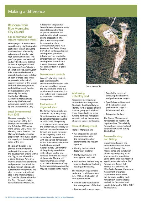
Former Lawson Tip<br />
Progressive development<br />
<strong>of</strong> Flood Plain Management<br />
Studies in <strong>the</strong> <strong>City</strong> is likely to<br />
identify fur<strong>the</strong>r parcels <strong>of</strong> land<br />
that are geographically lowlying.<br />
Council actively seeks<br />
funding <strong>for</strong> flood mitigation<br />
works to reduce <strong>the</strong> number<br />
<strong>of</strong> parcels subject to flooding.<br />
Plans <strong>of</strong> Management<br />
Plans <strong>of</strong> Management:<br />
• Are prepared by Council<br />
in consultation with<br />
<strong>the</strong> community, o<strong>the</strong>r<br />
stakeholders and relevant<br />
agencies<br />
• Identify <strong>the</strong> important<br />
features <strong>of</strong> <strong>the</strong> land<br />
• Clarify how Council will<br />
manage <strong>the</strong> land; and<br />
• Indicate how <strong>the</strong> land may be<br />
used or developed (including<br />
leasing and licensing).<br />
The minimum requirements<br />
under <strong>the</strong> Local Government<br />
Act, 1993 are that a plan <strong>of</strong><br />
management must:<br />
• Contain core objectives <strong>for</strong><br />
<strong>the</strong> management <strong>of</strong> <strong>the</strong> land<br />
• Contain per<strong>for</strong>mance targets<br />
• Specify <strong>the</strong> means <strong>of</strong><br />
achieving <strong>the</strong> objectives<br />
and per<strong>for</strong>mance targets<br />
• Specify how achievement<br />
<strong>of</strong> <strong>the</strong> objectives and<br />
per<strong>for</strong>mance target is<br />
to be assessed, and<br />
• Categorise <strong>the</strong> land.<br />
The Plan <strong>of</strong> Management<br />
<strong>for</strong> recreational facilities at<br />
Lapstone Oval (Tunnel Gully<br />
Reserve) was completed and<br />
adopted by Council during<br />
2005–2006.<br />
Reserve Fencing<br />
and Gating<br />
Unauthorised access into<br />
bushland reserves has been<br />
restricted through <strong>the</strong><br />
maintenance and installation<br />
<strong>of</strong> fencing and gating at 16<br />
sites across <strong>the</strong> mountains.<br />
Some <strong>of</strong> <strong>the</strong> sites that received<br />
significant works include Bluff<br />
Reserve and Tunnel Gully<br />
Reserve in Glenbrook and<br />
Mike Eades Reserve, Katoomba.<br />
Assessment <strong>of</strong> signage<br />
requirement was carried<br />
out <strong>for</strong> seven walking track<br />
networks in <strong>the</strong> <strong>Mountains</strong><br />
and will be fabricated and<br />
installed during <strong>the</strong> 2006–2007<br />
financial year.<br />
20<br />
2005–2006 Supplementary <strong>State</strong> <strong>of</strong> <strong>the</strong> <strong>Environment</strong> <strong>Report</strong> <strong>for</strong> <strong>the</strong> <strong>City</strong> <strong>of</strong> <strong>Blue</strong> <strong>Mountains</strong>