

l66nu8g
l66nu8g
l66nu8g

Create successful ePaper yourself
Turn your PDF publications into a flip-book with our unique Google optimized e-Paper software.
example, soil temperatures near<br />
the TransCanada Keystone pipeline<br />
which runs through the Dakotas,<br />
Nebraska, Missouri, Kansas and<br />
Oklahoma will be elevated by<br />
around 2°F from late December<br />
through late August, and by as<br />
much as 5°F in early March, when<br />
the pipeline is running at its full<br />
capacity of 591,000 barrels per day.<br />
This may cause a decrease in soil<br />
moisture content, which would hurt<br />
farmers who use their land for production<br />
agriculture. 49<br />
Underground pipelines, including<br />
the crude oil pipelines currently<br />
being proposed and built, are not<br />
immune to leaks and spills, and in<br />
fact, their leaks would go directly<br />
into the soil without having to penetrate<br />
vegetation and surface layers.<br />
Because of the imperfect leak<br />
detection mechanism, small leaks<br />
can be present for as much as three<br />
months and penetrate multiple layers<br />
of soil before being detected.<br />
Catastrophic leaks or ruptures are<br />
detected far more quickly, but even<br />
in just a few minutes, can involve<br />
thousands of barrels of oil. 50 Since<br />
1973, Enbridge, a pipeline company<br />
currently building tar sands oil pipelines<br />
in the United States, has been<br />
responsible for over four million<br />
gallons of hazardous liquids (primarily<br />
crude oil) spilled from pipelines;<br />
between 2003 and 2008, Enbridge<br />
pipeline accidents were responsible<br />
for 13 fatalities, 29 injuries and $633<br />
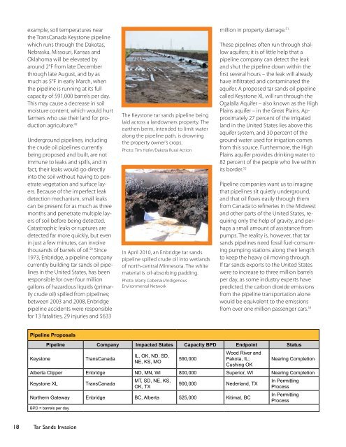
The Keystone tar sands pipeline being<br />
laid across a landowners property. The<br />
earthen berm, intended to limit water<br />
along the pipeline path, is drowning<br />
the property owner’s crops.<br />
Photo: Tim Hofer/Dakota Rural Action<br />
In April 2010, an Enbridge tar sands<br />
pipeline spilled crude oil into wetlands<br />
of north-central Minnesota. The white<br />
material is oil-absorbing padding.<br />
Photo: Marty Cobenais/Indigenous<br />
Environmental Network<br />
million in property damage. 51<br />
These pipelines often run through shallow<br />
aquifers; it is of little help that a<br />
pipeline company can detect the leak<br />
and shut the pipeline down within the<br />
first several hours – the leak will already<br />
have infiltrated and contaminated the<br />
aquifer. A proposed tar sands oil pipeline<br />
called Keystone XL will run through the<br />
Ogalalla Aquifer – also known as the High<br />
Plains aquifer – in the Great Plains. Approximately<br />
27 percent of the irrigated<br />
land in the United States lies above this<br />
aquifer system, and 30 percent of the<br />
ground water used for irrigation comes<br />
from this source. Furthermore, the High<br />
Plains aquifer provides drinking water to<br />
82 percent of the people who live within<br />
its border. 52<br />
Pipeline companies want us to imagine<br />
that pipelines sit quietly underground,<br />
and that oil flows easily through them<br />
from Canada to refineries in the Midwest<br />
and other parts of the United States, requiring<br />
only the help of gravity, and perhaps<br />
a small amount of assistance from<br />
pumps. The reality is, however, that tar<br />
sands pipelines need fossil fuel-consuming<br />
pumping stations along their length<br />
to keep the heavy oil moving through.<br />
If tar sands exports to the United States<br />
were to increase to three million barrels<br />
per day, as some industry experts have<br />
predicted, the carbon dioxide emissions<br />
from the pipeline transportation alone<br />
would be equivalent to the emissions<br />
from over one million passenger cars. 53<br />
Pipeline Proposals<br />
Keystone<br />
Pipeline Company Impacted States Capacity BPD Endpoint Status<br />
TransCanada<br />
IL, OK, ND, SD,<br />
NE, KS, MO<br />
590,000<br />
Wood River and<br />
Pakota, IL;<br />
Cushing OK<br />
Nearing Completion<br />
Alberta Clipper Enbridge ND, MN, WI 800,000 Superior, WI Nearing Completion<br />
Keystone XL<br />
TransCanada<br />
MT, SD, NE, KS,<br />
OK, TX<br />
900,000 Nederland, TX<br />
Northern Gateway Enbridge BC, Alberta 525,000 Kitimat, BC<br />
BPD = barrels per day<br />
In Permitting<br />
Process<br />
In Permitting<br />
Process<br />
18 Tar Sands Invasion