SmartCode Summary Report
SmartCode Summary Report
SmartCode Summary Report

Create successful ePaper yourself
Turn your PDF publications into a flip-book with our unique Google optimized e-Paper software.
<strong>SmartCode</strong> 6.5 | 2005<br />
SECTION 2: SECTOR-SCALE PLANS<br />
2.1 INSTRUCTIONS<br />
2.1.1 Sector Plans should be prepared by the [Planning<br />
Office] and consultants under its supervision in a<br />
process of public participation and approved by [The<br />
Legislative Body].<br />
2.1.2 Sector Plans should integrate the largest practical<br />
geographic sector, overlapping property lines as<br />
necessary to achieve the ideal of a green infrastructure<br />
interspersed by urban communities.<br />
2.1.3 [Use Geographic Information Systems (GIS) to]<br />
identify criteria listed in Section 2.3 to map the areas<br />
to be designated S1-Preserved Open Space Sectors.<br />
The outline of this Sector is effectively a permanent<br />
Rural Boundary Line (RBL). All other areas may qualify<br />
for development conditional to the requirements of<br />
this Code.<br />
2.1.4 [Use GIS] to identify criteria listed in Section 2.4<br />
to map the areas to be designated S2-Reserved Open<br />
Space Sector. Within this Sector an Urban Boundary<br />
Line (UBL) is adjustable as Community Plans are permitted.<br />
2.1.5 [Use GIS] to identify and map the S6-Existing<br />
Urbanized Sectors as described in Section 2.8. These<br />
areas may be redeveloped according to Existing<br />
Community Plans (Section 4).<br />
2.1.6 All remaining areas are available for development<br />
as New Community Plans (Section 3). Factoring<br />
the existing zoning, the sector transportation plans,<br />
parcel size and other criteria [determined through<br />
a process of public participation], these areas shall<br />
be assigned to one of the three Growth Sectors (S3,<br />
S4 and S5) described in Sections 2.5, 2.6 and 2.7.<br />
Within these Sectors, the corresponding Community<br />
Types of CLD, TND, and RCD, as set forth in Section 3,<br />
shall be permitted by right [while the (Existing Zoning<br />
Ordinance) and its permitting process remain as an<br />
option.]<br />
2.1.7 Where transit service is planned or available,<br />
Regional Centers shall be re-designated a Transit-<br />
Oriented Developments (TOD).<br />
2.1.8 Allocate those areas that are justified for specialized<br />
uses (those that cannot conform to one of<br />
the six Transect Zones specified by this code and<br />
described in Table 3) to Specialized Districts.<br />
2.1.9 Establish and administer a system for the gradual<br />
Transfer of Development Rights (TDR) from the S2-Reserved<br />
Open Space Sectors to the S4 and S5 Growth<br />
Sectors. The TDRs are available to exceed the allocated<br />
densities of the New Communities (Section 3.5<br />
and Table 19B). The TDR sending areas, the Reserve<br />
Sectors, thereby become part of the Preserve Sectors.<br />
[The TDR system may be carried out by the initiative of<br />
private-sector realtors for market-rate fees.] The [Planning<br />
Office] shall maintain a record of such transfers,<br />
updating the sector map accordingly.<br />
2.2 SUCCESSION<br />
2.2.1 [Twenty] years after the approval is granted,<br />
each Transect Zone, except the T1 Natural, shall be<br />
considered for rezoning to the successional (next<br />
higher) Transect Zone through public hearing by the<br />
[Legislative Body].<br />
2.3 (S1) PRESERVE OPEN SPACE SECTOR<br />
2.3.1 The Preserve Sector shall consist of open space<br />
that is protected from development in perpetuity. The<br />
Preserve Sector includes areas under environmental<br />
protection by law or standard, as well as land acquired<br />
for conservation through purchase, by easement,<br />
or by past sale of development rights.<br />
2.3.2 The Preserve Sector shall consist of the aggregate<br />
of the following categories:<br />
a. Surface Waterbodies<br />
b. Protected Wetlands<br />
c. Protected Habitat<br />
d. Riparian Corridors<br />
e. Purchased Open Space<br />
f. Conservation Easements<br />
g. Transportation Corridors<br />
h. Residual to Cluster Open Space (CLD)<br />
i. [Other Categories]<br />
2.3.3 Development and construction within the Preserve<br />
Sector and the specifications required to do so<br />
shall be determined on an individual project basis in<br />
public hearing of the [Legislative Body].<br />
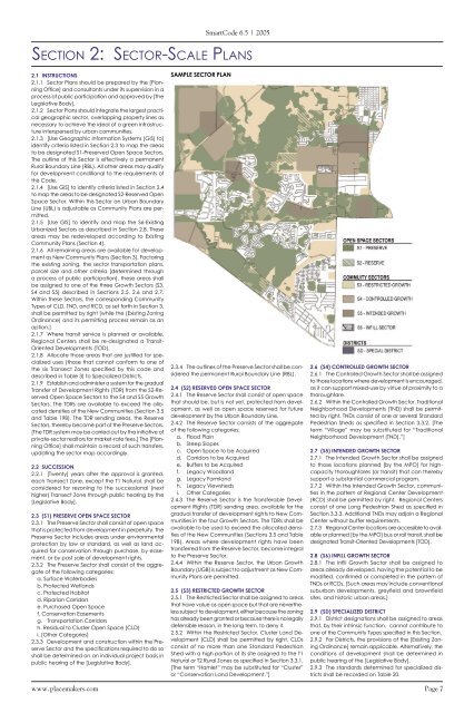
SAMPLE SECTOR PLAN<br />
2.3.4 The outlines of the Preserve Sector shall be considered<br />
the permanent Rural Boundary Line (RBL).<br />
2.4 (S2) RESERVED OPEN SPACE SECTOR<br />
2.4.1 The Reserve Sector shall consist of open space<br />
that should be, but is not yet, protected from development,<br />
as well as open space reserved for future<br />
development by the Urban Boundary Line.<br />
2.4.2 The Reserve Sector consists of the aggregate<br />
of the following categories:<br />
a. Flood Plain<br />
b. Steep Slopes<br />
c. Open Space to be Acquired<br />
d. Corridors to be Acquired<br />
e. Buffers to be Acquired<br />
f. Legacy Woodland<br />
g. Legacy Farmland<br />
h. Legacy Viewsheds<br />
i. Other Categories<br />
2.4.3 The Reserve Sector is the Transferable Development<br />
Rights (TDR) sending area, available for the<br />
gradual transfer of development rights to New Communities<br />
in the four Growth Sectors. The TDRs shall be<br />
available to be used to exceed the allocated densities<br />
of the New Communities (Sections 3.5 and Table<br />
19B). Areas where development rights have been<br />
transferred from the Reserve Sector, become integral<br />
to the Preserve Sector.<br />
2.4.4 Within the Reserve Sector, the Urban Growth<br />
Boundary (UGB) is subject to adjustment as New Community<br />
Plans are permitted.<br />
2.5 (S3) RESTRICTED GROWTH SECTOR<br />
2.5.1 The Restricted Sector shall be assigned to areas<br />
that have value as open space but that are nevertheless<br />
subject to development, either because the zoning<br />
has already been granted or because there is no legally<br />
defensible reason, in the long term, to deny it.<br />
2.5.2 Within the Restricted Sector, Cluster Land Development<br />
(CLD) shall be permitted by right. CLDs<br />
consist of no more than one Standard Pedestrian<br />
Shed with a high portion of its site assigned to the T1<br />
Natural or T2 Rural Zones as specified in Section 3.3.1.<br />
[The term “Hamlet” may be substituted for “Cluster”<br />
or “Conservation Land Development.”]<br />
2.6 (S4) CONTROLLED GROWTH SECTOR<br />
2.6.1 The Controlled Growth Sector shall be assigned<br />
to those locations where development is encouraged,<br />
as it can support mixed-use by virtue of proximity to a<br />
thoroughfare.<br />
2.6.2 Within the Controlled Growth Sector, Traditional<br />
Neighborhood Developments (TND) shall be permitted<br />
by right. TNDs consist of one or several Standard<br />
Pedestrian Sheds as specified in Section 3.3.2. [The<br />
term “Village” may be substituted for “Traditional<br />
Neighborhood Development (TND).”]<br />
2.7 (S5) INTENDED GROWTH SECTOR<br />
2.7.1 The Intended Growth Sector shall be assigned<br />
to those locations planned [by the MPO] for highcapacity<br />
thoroughfares (or transit) that can thereby<br />
support a substantial commercial program.<br />
2.7.2 Within the Intended Growth Sector, communities<br />
in the pattern of Regional Center Development<br />
(RCD) shall be permitted by right. Regional Centers<br />
consist of one Long Pedestrian Shed as specified in<br />
Section 3.3.3. Additional TNDs may adjoin a Regional<br />
Center without buffer requirements.<br />
2.7.3 Regional Center locations are accessible to available<br />
or planned [by the MPO] bus or rail transit, shall be<br />
designated Transit-Oriented Developments (TOD).<br />
2.8 (S6) INFILL GROWTH SECTOR<br />
2.8.1 The Infill Growth Sector shall be assigned to<br />
areas already developed, having the potential to be<br />
modified, confirmed or completed in the pattern of<br />
TNDs or RCDs. [Such areas may include conventional<br />
suburban developments, greyfield and brownfield<br />
sites, and historic urban areas.]<br />
2.9 (SD) SPECIALIZED DISTRICT<br />
2.9.1 District designations shall be assigned to areas<br />
that, by their intrinsic function, cannot contribute to<br />
one of the Community Types specified in this Section.<br />
2.9.2 For Districts, the provisions of the [Existing Zoning<br />
Ordinance] remain applicable. Alternatively, the<br />
conditions of development shall be determined in<br />
public hearing of the [Legislative Body].<br />
2.9.3 The standards determined for specialized districts<br />
shall be recorded on Table 20.<br />
www.placemakers.com Page 7