East Anglia ONE Offshore Windfarm - National Infrastructure Planning
East Anglia ONE Offshore Windfarm - National Infrastructure Planning
East Anglia ONE Offshore Windfarm - National Infrastructure Planning

Create successful ePaper yourself
Turn your PDF publications into a flip-book with our unique Google optimized e-Paper software.
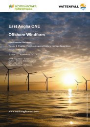
52°30'0"N<br />
52°20'0"N<br />
52°10'0"N<br />
52°0'0"N<br />
51°50'0"N<br />
Legend<br />
D atum : W GS84<br />
Projection: U TM 31N<br />
© E SR I<br />
0°50'0"E<br />
0°50'0"E<br />
E ast <strong>Anglia</strong> O ne project area<br />
Indicative cable corridor area<br />
1°0'0"E<br />
1°0'0"E<br />
E ast <strong>Anglia</strong> O ffshore W ind zone boundary<br />
") 400 kv substations<br />
Bramford<br />
1°10'0"E<br />
1°10'0"E<br />
R ef: E AO W 1_CabCoAoI_v01_100928rs, Bram ford_GridSStn_v01_100813rs_O SN G, R ound_3_Zones_Iteration_III (N am e = N orfolk)<br />
1°20'0"E<br />
1°20'0"E<br />
3 14/09/10 R S Indicative cable corridor am ended (northern lim it).<br />
1°30'0"E<br />
CblCorr clipped to R .Stour to S and district bdry to W . Grid circuits<br />
21 07/09/10 13/08/10 R S and Indicative 400 kv substns cable corridor digitised to amreflect ended.<br />
1:50k O S<br />
A 28/09/10 R S F irst Issue<br />
Rev Date By Comment<br />
1°30'0"E<br />
O riginal A3<br />
Plot Scale<br />
1:350,000<br />
1°40'0"E<br />
1°40'0"E<br />
1°50'0"E<br />
1°50'0"E<br />
0 2 4km 0 2 4nm<br />
© British Crown and SeaZone Solutions L im ited. Al rights reserved. Products L icence N o. 042010.006. This product<br />
has been derived in part from m aterial obtained from the U K Hydrographic O ffice with the perm ission of the Controler of<br />
Her M ajesty’s Stationery O ffice and the U K Hydrographic O ffice (www.ukho.gov.uk). N O T TO BE U SE D F O R N AVIGATIO N .<br />
© E ast <strong>Anglia</strong> O ffshore W ind L im ited 2010. Contains O rdnance Survey data © Crown copyright, Al rights reserved 2010.<br />
L icence num ber 0100049003.<br />
2°0'0"E<br />
2°0'0"E<br />
2°10'0"E<br />
2°10'0"E<br />
2°20'0"E<br />
2°20'0"E<br />
<strong>East</strong> <strong>Anglia</strong> <strong>Offshore</strong> Wind<br />
E ast <strong>Anglia</strong> O ne project area and indicative cable<br />
corridor<br />
2°30'0"E<br />
2°30'0"E<br />
D rg N o 6115-700-PA-035<br />
R ev<br />
D ate<br />
A<br />
28/09/10<br />
L ayout N /A<br />
2°40'0"E<br />
F<br />
2°40'0"E<br />
F igure<br />
F I 1<br />
52°30'0"N<br />
52°20'0"N<br />
52°10'0"N<br />
52°0'0"N<br />
51°50'0"N