Datum Diagrams - National Geodetic Survey
Datum Diagrams - National Geodetic Survey
Datum Diagrams - National Geodetic Survey

Create successful ePaper yourself
Turn your PDF publications into a flip-book with our unique Google optimized e-Paper software.
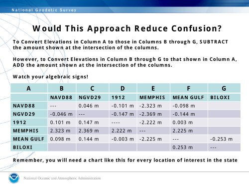
Would This Approach Reduce Confusion?To Convert Elevations in Column A to those in Columns B through G, SUBTRACTthe amount shown at the intersection of the columns.However, to Convert Elevations in Column B through G to that shown in Column A,ADD the amount shown at the intersection of the columns.Watch your algebraic signs!A B C D E F GNAVD88 NGVD29 1912 MEMPHIS MEAN GULF BILOXINAVD88 --- 0.046 m -0.101 m -2.323 m -0.098 mNGVD29 -0.046 m --- -0.147 m -2.369 m -0.144 m1912 0.101 m 0.147 m ---- -2.222 m 0.003 mMEMPHIS 2.323 m 2.369 m 2.222 m --- 2.225 mMEAN GULF 0.098 m 0.144 m -0.003 m -2.225 m --- -0.253 mBILOXI 0.253 m ---Remember, you will need a chart like this for every location of interest in the state