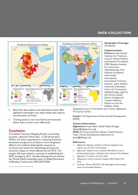
GLOBAL TRACHOMA MAPPING PROJECTGIS mapping to achieve the Global Elimination of Blinding Trachoma by 2020Trachoma is a neglected tropical disease (NTD) thataffects over 21 million people and is endemic in 53countries. While it has been eliminated in mostdeveloped countries, it is still the world’s leadinginfectious cause of blindness and affects the poorestcommunities. Women and children living in hot, dryand dusty areas with poor access to water andsanitation are especially susceptible. An estimated 229million people worldwide live in highly trachomaprevalent areas and are at risk of going blind ifrepeated infections are left untreated. Ethiopia is themost adversely affected country by Trachoma. InOromia and Tigray regions alone, over 30 millionpeople are at risk.To aid in identifying, treating and eliminating trachoma inEthiopia and worldwide, the International TrachomaInitiative (ITI), NGOs and academic institutions, led bythe UK non-profit Sightsavers, launched the GlobalTrachoma Mapping Project (GTMP). The GTMP is thelargest disease-mapping project ever attempted. In twoand one half years, up to 4 million people will besurveyed in over 1,200 suspected-endemic districts inmore than 30 countries, including more than one-thirdof African countries. Mapping will be completed byMarch 2015 to facilitate countries implementation of theSAFE Strategy (Surgery, Antibiotics, Facial cleanliness,Environmental improvement) to treat and preventtrachoma and reach the WHO-endorsed GlobalElimination of Blinding Trachoma by 2020 (GET2020)target.Data from household surveys are collected onsmartphones via the LINKS System. ITI is the stewardfor the data, which are made available in categoricalform on open-access disease maps on the TrachomaAtlas website (www.trachomaatlas.org).Implementation date: December 2012About Global Trachoma MappingOver 300 survey teams have already been trained togather prevalence data. Each team is comprised of onegrader and one data recorder who are supported bycoordinators, drivers, field supervisors, local guides, andlogistics and finance personnel.Field data are collected using the ArcGIS mappingplatform and Open Data Kit-based software, a flexiblesmart phone-based tool that runs on devices using theAndroid operating system. Global Positioning System(GPS) readings are also taken for every householdsurveyed. Data are then securely transferred from thefield to a central web-based reporting and datamanagement tool, where they are quickly analyzed,approved and shared by Ministries of Health, using adynamic web-interface. WASH (waster, sanitation andhygiene) and other NTD mapping is also conducted togain a broader picture of poverty and developmentissues affecting trachoma endemic populations. If there islimited cellular connection, data are stored in the mobiledevice’s micro SD card and uploaded when the surveyteam can access the internet or a cellular connection.Data will be available in-country through the country’sown Health Management Information System. Onceapproved by the MOH, data are published, shared andupdated through the open-access Trachoma Atlaswebsite which contains free country maps withpopulation-based trachoma prevalence data at thedistrict level.Evaluation and ResultsIn June of 2013, trachoma prevalence data collected by40 survey teams as part of the project's first phase inEthiopia’s Oromia (252 districts) and Tigray (48districts ) regions was approved by the Regional HealthBureaus and the Ethiopian Federal Ministry of Health.This gives health officials the ability to plan trachomaelimination programs for over 30 million people at riskin these areas.As of September, 1 million people in Ethiopia, Nigeria,Malawi, Mozambique, Solomon Islands and Yemen havebeen checked for trachoma.Lessons Learned Standardization is key to scale-upExternal support is welcomed by countries andcommunities24 mHEALTH COMPENDIUM | VOLUME 3
DATA COLLECTIONGeographic Coverage:WorldwideElectronic data capture and web-based review offersignificant advantages over paper-based data captureand discussion via emailTraining teams in new (not home) environmentsallows them to learn more effectivelyConclusionThe Global Trachoma Mapping Project is providingaccurate, rapid and robust data. It will aid partners,MOHs, and other organizations in tailoring trachomaelimination programs to produce a more integrated,efficient and evidence-based global response totrachoma and reduce the devastating personal andeconomic impact on those affected by the NTD. Theproject will assist endemic countries in establishing theSAFE strategy by 2015, thereby allowing time to achievethe World Health Assembly’s goal of Global Eliminationof Blinding Trachoma by 2020 (GET2020)----------------------------------------ImplementationPartners: InternationalCoalition for TrachomaControl, African Medicaland Research Foundation,CBM, Blantyre Institutefor CommunityOphthalmology, FredHollows Foundation,Helen KellerInternational,International TrachomaInitiative, Johns HopkinsUniversity, KilimanjaroCentre for CommunityOphthalmology, Light forthe World, LondonSchool of Hygiene &Tropical Medicine,Mission to save theHelpless, Orbis,Organisation pour la Prévention de la Cécité, Sightsavers,The Carter CenterFunder: UK Department of International Development(DFID)Contact Information:Sightsavers: Freya Paleit, Global Media Manager(fpaleit@sightsavers.org)DFID: Iain Jones, Economic Adviser, Health ServicesTeam, Human Development Department (I-Jones@dfid.gov.uk)References:1. Sightsavers. Ethiopia completes trachoma mapping in tworegions. June 24, 2013. Press Release.2. Sightsavers. Global survey to identify 180 million at risk ofblinding disease begins in Ethiopia. Date unknown. Press Release.3. Sightsavers. Trachoma. No date. Web.4. Mapping the world’s trachoma hotspots. IRIN Global. 2013.Web.5. ArcNews. Winter 2012/2013. GIS Helps fight world’s leadingcause of preventable blindness.mHEALTH COMPENDIUM | VOLUME 3 25