© Scott NeweyA review <strong>of</strong> <strong>the</strong> effects <strong>of</strong> game birdmanagement on non-game species’Scott Newey, Karen Mustin, Steve Redpath and Justin Irvine12BackgroundAcross Europe, game bird hunting occurs over millions <strong>of</strong>hectares <strong>of</strong> land, and provides economic and social benefits.Game birds and <strong>the</strong>ir habitat are <strong>of</strong>ten intensely managedto increase population density. Here we set out to assess <strong>the</strong>consequences for non-target species.Research questionsAll management activities can have positive and negativeeffects on certain species. We reviewed <strong>the</strong> literature to assess<strong>the</strong> evidence for <strong>the</strong> effects <strong>of</strong> different types <strong>of</strong> managementon o<strong>the</strong>r species also present in <strong>the</strong> habitats managed forgame birds.MethodWe considered five broad management activities: predatorcontrol, habitat management, provision <strong>of</strong> supplementaryfood and water, rear and release, and parasite/diseasecontrol and reviewed published literature to collate andsyn<strong>the</strong>sise our current understanding <strong>of</strong> <strong>the</strong> impacts <strong>of</strong> <strong>the</strong>semanagement activities on <strong>the</strong> abundance, diversity, breedingsuccess and survival <strong>of</strong> non-game species. We reviewed 41studies.Key <strong>findings</strong>The published evidence suggests that game bird managementcan have positive effects on some non-game species andnegative effects on o<strong>the</strong>rs. Predator control is one <strong>of</strong> <strong>the</strong> mostwell studied aspects <strong>of</strong> game bird management results mainlyshow positive or no significant effect on non-game species.However, illegal control <strong>of</strong> protected predators has clearnegative effects on some predator populations. Habitatmanagement in agricultural areas generally has positiveeffects on a range <strong>of</strong> species, while <strong>the</strong> effects <strong>of</strong> managementin non-agricultural areas are more variable. Whilst <strong>the</strong>re area number <strong>of</strong> negative effects <strong>of</strong> rear and release, <strong>the</strong>re is little<strong>research</strong> concerning how this form <strong>of</strong> management affects<strong>the</strong> abundance, diversity, breeding success and survival <strong>of</strong>non-game species. While some aspects <strong>of</strong> <strong>the</strong> effects <strong>of</strong> gamebird management on non-game species are well studiedo<strong>the</strong>r areas are less well <strong>research</strong>ed, in particular <strong>the</strong>re is littleknown on <strong>the</strong> effects <strong>of</strong> <strong>the</strong> provision <strong>of</strong> supplemental foodand water, and studies to assess <strong>the</strong> impacts <strong>of</strong> parasite anddisease control on non-game wildlife are generally lacking.Lessons learnt for best practiceDespite many shared goals, hunting and conservation are<strong>of</strong>ten in real or perceived conflict over management objectivesand practices. Although more data are clearly needed to fullyunderstand <strong>the</strong> broader biodiversity effects and trade-<strong>of</strong>fsassociated with different management activities, <strong>the</strong> availableevidence suggests that, with <strong>the</strong> exception <strong>of</strong> illegal predatorcontrol and release <strong>of</strong> exotic species, game bird managementpractices are positive or benign for non-game species.Two birds with one stone: can biodiversity conservation and game bird management be reconciled? Mustin, K., Arroyo, B., Beja, P., Bro, E., Irvine, R.J.,Newey, S. & Redpath, S. [Manuscript in preparation].
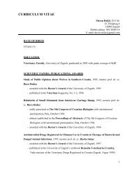
© Adam SmithThe same but different:Upland management and birddiversity in <strong>the</strong> <strong>Scottish</strong> HighlandsScott Newey, Karen Mustin, Ros Bryce, Debbie Fielding,Steve Redpath and Justin Irvine13BackgroundThe protection <strong>of</strong> biodiversity is a key national and international policy objective.While protected areas provide one approach, <strong>the</strong> majority <strong>of</strong> land lies outside<strong>of</strong> protected areas and is subject to different, and <strong>of</strong>ten multiple, land uses.Understanding how biodiversity can be maximised amongst <strong>the</strong> varied pressures<strong>of</strong> o<strong>the</strong>r forms <strong>of</strong> land use is important for evaluating <strong>the</strong> effects <strong>of</strong> different policyobjectives.Research questionsHow do different forms <strong>of</strong> upland management objectives and practices influencebird diversity and community composition?MethodHea<strong>the</strong>r moorland on twenty six upland estates with a variety <strong>of</strong> differentmanagement objectives was surveyed for breeding birds in spring-summer 2010.On each estate two to four 1km 2 areas were surveyed using a modified version <strong>of</strong><strong>the</strong> Breeding Bird Survey methodology, where each 1km 2 area was traversed by2 parallel 1km long transects spaced 500m apart. Each 1km 2 area was surveyedtwice, once in April–May and again in May–June. All birds directly associated with<strong>the</strong> survey area were identified and recorded. Survey data were used to estimate birdspecies diversity using <strong>the</strong> Shannon Index. We also used (Non-metric Multi-dimensionalScaling) ordination to explore patterns in bird community composition andstructure. For each estate we asked for information on <strong>the</strong> dominant managementobjectives and predator control. We used satellite imagery to estimate <strong>the</strong> percentage<strong>of</strong> land in each survey area which was subject to muirburn. Finally, we used <strong>the</strong> LandClassification 2007 data to estimate habitat diversity for each estate.