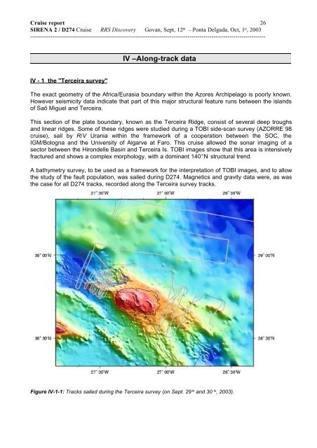
<strong>Cruise</strong> report 26SIRENA 2 / D274 <strong>Cruise</strong> RRS Discovery Govan, Sept, 12 th – Ponta Delgada, Oct, 1 st , 2003----------------------------------------------------------------------------------------------------------------------IV –Along-track dataIV - 1 the "Terceira survey"The exact geometry of the Africa/Eurasia boundary within the Azores Archipelago is poorly known.However seismicity data indicate that part of this major structural feature runs between the islandsof Saõ Miguel and Terceira.This section of the plate boundary, known as the Terceira Ridge, consist of several deep troughsand linear ridges. Some of these ridges were studied during a TOBI side-scan survey (AZORRE 98cruise), sail by R/V Urania within the framework of a cooperation between the SOC, theIGM/Bologna and the University of Algarve at Faro. This cruise allowed the sonar imaging of asector between the Hirondelle Basin and Terceira Is. TOBI images show that this area is intensivelyfractured and shows a complex morphology, with a dominant 140°N structural trend.A bathymetry survey, to be used as a framework for the interpretation of TOBI images, and to allowthe study of the fault population, was sailed during D274. Magnetics and gravity data were, as wasthe case for all D274 tracks, recorded along the Terceira survey tracks.Figure IV-1-1: Tracks sailed during the Terceira survey (on Sept. 29 th and 30 th , 2003).
<strong>Cruise</strong> report 27SIRENA 2 / D274 <strong>Cruise</strong> RRS Discovery Govan, Sept, 12 th – Ponta Delgada, Oct, 1 st , 2003----------------------------------------------------------------------------------------------------------------------Luis, J. F., J. M. Miranda, A. Galdeano, P. Patriat , Constraints on The Structure of the Azores Spreading Center fromGravity Data. Marine Geophysical Research, 20, 157-170, 1998.Lourenço, N, J. M. Miranda, J. F. Luis, A. Ribeiro, L.A. Men<strong>des</strong> Victor, Madeira, J & H. D. Needham, Morpho-tectonicanalysis of the Azores Volcanic Plateau from a new bathymetric compilation of the area. Marine GeophysicalResearch, 20, 141-156, 1998.Miranda, J. M., L. A. Men<strong>des</strong> Victor, J. Z. Simões, J. F. Luis, L. Matias, H. Shimamura, H. Shiobara, H Nemoto, H.Mochizuki, A. Hirn, J. C. Lépine, Tectonic setting of the Azores Plateau deduced from a OBS survey. Mar GeophysRes, 20, 171-182, 1998.J. Freire Luis, J.M. Miranda, A. Galdeano, P. Patriat, J.C. Rossignol and L.A. Men<strong>des</strong> Victor. Azores Triple Junctionevolution since 10 Ma from an Aeromagnetic survey of the Mid-Atlantic Ridge. Earth and Planetary Science Letters125, 439-459, 1994.Luis J. F., N. Lourenço, J. M. Miranda, J. L.Gaspar and G. Queiroz. A Submarine Eruption west of Terceira Island(Azores Archipelago). Interridge News. Vol 8: Nº1: 13-14, 1999.Ligi M., N. C. Mitchell, M. Marani, F. Gamberi, D. Penitenti, G. Carrara, M. Rovere, R. Portaro, G. Centorami, G.Bortoluzzi, C. Jacobs, I. Rouse, C. Flewellen, S. Whittle, P. Terrinha, J. Freire Luis and N. Lourenço. GiantVolcanic Ridges Amongst the Azores islands. Fall Meeting of the American Geophysical Union, 1999.Ligi M., N. C. Mitchell, M. Marani, G. Carrara, F. Jacobs, N. Lourenço, J. F. Luis, D. Penitenti, R. Poraro, M. Rovere, P.Terrinha. Tectonic control on the growth of giant Volcanic Ridges in the Azores. XXV EGS, Nice, 2000.Lourenço N., J. Luis, M. Miranda, M. Ligi, and the AZORRE 99 Team. Linear Volcanic Ridges in the Azores: preliminarycharacterization from TOBI data. 3º Simpósio da Margem Ibérica Atlântica, Faro, p 197, 2000.IV - 2 other along-track dataSingle beam PDR, towed proton magnetometer and shipboard gravity data were continuouslyrecorded along the ship’s tracks during D274.These tracks were planed in three different contexts:- first, we endeavored to avoid night-time mooring operations by sailing short-duration magneticprofiles in the vicinity of the mooring sites, if we were to be arriving on site after night fall.Similarly, we adapted the transit time between sites so as to reach the next site not sooner thandaybreak, whenever possible, by bridging gaps in magnetic anomaly contour picks.- Second, we spent two nights sailing magnetic lines in the vicinity of site S3, in between theattempts to recover the instrument.- Third, we devoted two days to the sailing of a magnetic survey of the eastern flank of the Mid-Atlantic Ridge, north and south of site S1, after the recovery of hydrophone S1 was completedand before beginning the Terceira Survey.Details on how the along-track data were recorded and processed on board (essentially to edit thespurious magnetic and gravity data) are given below, and linear plots of the along-track data can befound in the subsequent appendix..IV – 3 Data processingThe RSS Discovery sailed close to 4400 nautical miles ( close to 8150 km) during theSirena2/D274 cruise. Single-beam bathymetry was recorded along ////// miles, magnetics along /////miles and gravity along //// miles. RSS Discovery sailed from Govan on Sept., 12 th (day 255) at