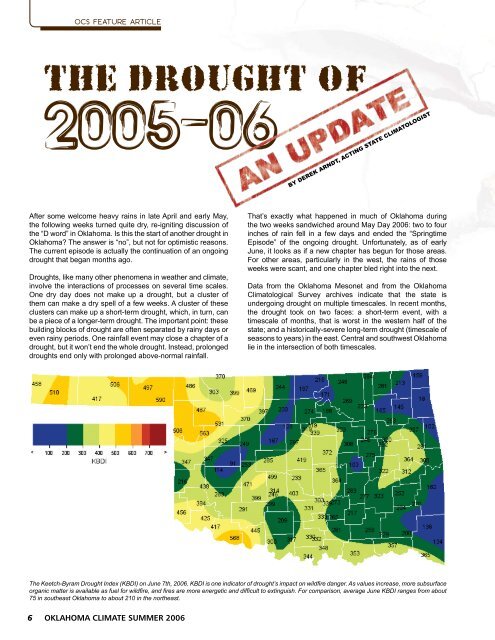
OCS FEATURE ARTICLEThe Drought ofBY DEREK ARNDT, ACTING STATE CLIMATOLOGISTAfter some welcome heavy rains in late April and early May,the following weeks turned quite dry, re-igniting discussion ofthe “D word” in <strong>Oklahoma</strong>. Is this the start of another drought in<strong>Oklahoma</strong>? The answer is “no”, but not for optimistic reasons.The current episode is actually the continuation of an ongoingdrought that began months ago.Droughts, like many other phenomena in weather and climate,involve the interactions of processes on several time scales.One dry day does not make up a drought, but a cluster ofthem can make a dry spell of a few weeks. A cluster of theseclusters can make up a short-term drought, which, in turn, canbe a piece of a longer-term drought. The important point: thesebuilding blocks of drought are often separated by rainy days oreven rainy periods. One rainfall event may close a chapter of adrought, but it won’t end the whole drought. Instead, prolongeddroughts end only with prolonged above-normal rainfall.That’s exactly what happened in much of <strong>Oklahoma</strong> duringthe two weeks sandwiched around May Day 2006: two to fourinches of rain fell in a few days and ended the “SpringtimeEpisode” of the ongoing drought. Unfortunately, as of earlyJune, it looks as if a new chapter has begun for those areas.For other areas, particularly in the west, the rains of thoseweeks were scant, and one chapter bled right into the next.Data from the <strong>Oklahoma</strong> Mesonet and from the <strong>Oklahoma</strong><strong>Climatological</strong> <strong>Survey</strong> archives indicate that the state isundergoing drought on multiple timescales. In recent months,the drought took on two faces: a short-term event, with atimescale of months, that is worst in the western half of thestate; and a historically-severe long-term drought (timescale ofseasons to years) in the east. Central and southwest <strong>Oklahoma</strong>lie in the intersection of both timescales.The Keetch-Byram Drought Index (KBDI) on June 7th, 2006. KBDI is one indicator of drought’s impact on wildfire danger. As values increase, more subsurfaceorganic matter is available as fuel for wildfire, and fires are more energetic and difficult to extinguish. For comparison, average June KBDI ranges from about75 in southeast <strong>Oklahoma</strong> to about 210 in the northeast. OKLAHOMA CLIMATE SUMMER 2006
OCS FEATURE ARTICLEOK RegionRank by Time Scale: For Periods Ending June 7th30-Day 60-Day 90-Day 120-Day 180-Day 365-Day Two-Year1-Panhandle 4th 2nd 9th 4th 2nd 10th 43rd2-North Central 6th 18th 21st 12th 6th 28th 34th3-Northeast 10th 47th 42nd 30th 15th 11th 20th4-West Central 12h 19th 22nd 13th 9th 37th 63rd5-Central 1st 13th 16th 11th 3rd 15th 25th6-East Central 5th 24th 28th 19th 9th 1st 14th7-Southwest 5th 8th 17th 10th 4th 13th 31st8-South Central 3rd 19th 34th 25th 12th 17th 30th9-Southeast 20th 28th 48th 29th 14th 1st 2ndOK-Statewide 2nd 14th 21st 12th 7th 10th 21stHistorical Rank: Among five driest.Historical Rank: 6th through 10th driest.Historical Rank: Among driest quarter.Description: These cells show the historical rank of recentprecipitation on seven time scales. Current values arecompared to history’s analogous period ending June 7th.Historical Rank of the Current DroughtThis table displays the historical rank of rainfall statistics at different timescales. Each is compared to a history made up of the equivalent time periods since1921. For example: a rank of “6th” for north-central <strong>Oklahoma</strong>’s 180-day rainfall indicates that the 180-day total (Dec 10th, 2005 through June 7th, 2006) isthe 6th-driest such period of the 85 on record. The darkest shades of orange indicate that the current period is among the five-driest on record.The southeast has experienced drought or near-droughtconditions since 2002, with a distinct intensification in spring2005. Summer and fall 2005 brought a northward expansionof drought to fill the state’s eastern third. Recent months havebrought some relief to the region, but the underlying hydrologicissues still remain. Severe drought impacts then advancedwestward during the subsequent winter. Precipitation inApril eased immediate problems, but a warm, dry Mayhas exacerbated long-term drought conditions in much of<strong>Oklahoma</strong>.A general rule-of-thumb for drought impacts is “Longer isDeeper”. In other words, the longer a drought lasts, thedeeper its impacts are felt. Within weeks of onset, dry surfaceconditions can lead to enhanced fire danger, much like<strong>Oklahoma</strong> witnessed during the disastrous winter months of2005-06. During these months, more than half a million acreswere consumed by wildfire in six months. For reference, thisarea is larger than that consumed by tornadoes during anydecade in <strong>Oklahoma</strong> state history.Shortly after enhanced wildfire danger, agricultural impactsare often seen. Of course, the total impact of a drought onagriculture depends on its timing, and the 2005-06 droughtcould not have come at a worse time for <strong>Oklahoma</strong>’s winterwheat crop. Dryness took hold in western <strong>Oklahoma</strong> byOctober, when young wheat germinates. By crop’s end in earlysummer, an estimated two-thirds of the total yield was wipedout by Mother Nature. The summer harvest, estimated to beat 68 million bushels, should be the state’s smallest since the1950s.When drought lasts beyond weeks and months and intotimescales of seasons and years, drought impacts gosubterranean, and major hydrologic problems can develop. Asthe rainfall deficits surpass a year in the west, and two yearsin the east, groundwater storage and reservoir storage hassuffered. Lake Eufaula in the east and Lake Thunderbird incentral <strong>Oklahoma</strong> sit at about 75% conservation capacity. Inother words, a fourth of the intended storage of each lakeis gone. In western <strong>Oklahoma</strong> Altus-Lugert Reservoir sits atan eye-popping 49% of capacity: this does not bode well forcotton growers in the region.Unfortunately, the outlook for coming months is not optimistic.Because large-scale weather patterns typically move northwardduring the summer months, <strong>Oklahoma</strong>’s weather is morestrongly influenced by local conditions. A larger componentof summer weather is “homegrown”, which makes summer in<strong>Oklahoma</strong> much more sensitive than other seasons to recentrainfall patterns during the previous weeks. When late spring isdry in <strong>Oklahoma</strong>, the subsequent summers show a tendencytoward warmer and drier conditions.NOAA’s Climate Prediction Center calls for drought to persistacross the western <strong>Oklahoma</strong> through August 2006. The silverlining in this scenario is that the confidence and skill of longtermforecasts is very low compared to short term (day-to-day)weather forecasts.The <strong>Oklahoma</strong> <strong>Climatological</strong> <strong>Survey</strong> updates the state’sdrought information every day at: http://climate.ocs.ou.edu/drought.OKLAHOMA CLIMATE SUMMER 2006