

Vegetation types described for Bega Valley Shire - NSW Government
Vegetation types described for Bega Valley Shire - NSW Government
Vegetation types described for Bega Valley Shire - NSW Government

You also want an ePaper? Increase the reach of your titles
YUMPU automatically turns print PDFs into web optimized ePapers that Google loves.
State of the <strong>Vegetation</strong> Report <strong>for</strong> <strong>Bega</strong> <strong>Valley</strong> <strong>Shire</strong><br />
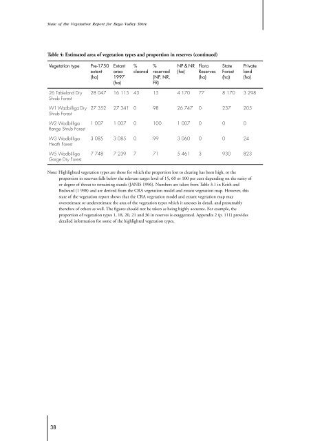
Table 4: Estimated area of vegetation <strong>types</strong> and proportion in reserves (continued)<br />
<strong>Vegetation</strong> type Pre-1750<br />
extent<br />
(ha)<br />
26 Tableland Dry<br />
Shrub Forest<br />
W1 Wadbilliga Dry<br />
Shrub Forest<br />
W2 Wadbilliga<br />
Range Shrub Forest<br />
W3 Wadbilliga<br />
Heath Forest<br />
W5 Wadbilliga<br />
Gorge Dry Forest<br />
Note: Highlighted vegetation <strong>types</strong> are those <strong>for</strong> which the proportion lost to clearing has been high, or the<br />
proportion in reserves falls below the relevant target level of 15, 60 or 100 per cent depending on the rarity of<br />
or degree of threat to remaining stands (JANIS 1996). Numbers are taken from Table 3.1 in Keith and<br />
Bedward (1 998) and are derived from the CRA vegetation model and extant vegetation map. However, this<br />
state of the vegetation report shows that the CRA vegetation model and extant vegetation map may<br />
overestimate or underestimate the area of the vegetation <strong>types</strong> which it assesses in detail, and presumably<br />
there<strong>for</strong>e of others as well. The figures should not be taken as being highly accurate. For example, the<br />
proportion of vegetation <strong>types</strong> 1, 18, 20, 21 and 36 in reserves is exaggerated. Appendix 2 (p. 111) provides<br />
detailed in<strong>for</strong>mation <strong>for</strong> some of the highlighted vegetation <strong>types</strong>.<br />
38<br />
Extant<br />
area<br />
1997<br />
(ha)<br />
%<br />
cleared<br />
%<br />
reserved<br />
(NP, NR,<br />
FR)<br />
NP & NR<br />
(ha)<br />
Flora<br />
Reserves<br />
(ha)<br />
State<br />
Forest<br />
(ha)<br />
28 047 16 115 43 15 4 170 77 8 170 3 298<br />
27 352 27 341 0 98 26 747 0 237 205<br />
1 007 1 007 0 100 1 007 0 0 0<br />
3 085 3 085 0 99 3 060 0 0 24<br />
Private<br />
land<br />
(ha)<br />
7 748 7 239 7 71 5 461 3 930 823