policy report - Census of Marine Life
policy report - Census of Marine Life
policy report - Census of Marine Life
- No tags were found...

Create successful ePaper yourself
Turn your PDF publications into a flip-book with our unique Google optimized e-Paper software.
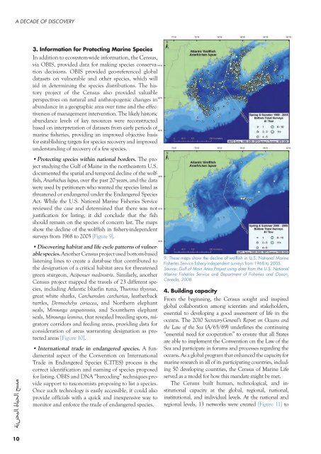
A DECADE OF DISCOVERY3. Information for Protecting <strong>Marine</strong> SpeciesIn addition to ecosystem-wide information, the <strong>Census</strong>,via OBIS, provided data for making species conservationdecisions. OBIS provided geo-referenced globaldatasets on vulnerable and other species, which willaid in determining the species distributions. The historyproject <strong>of</strong> the <strong>Census</strong> also provided valuableperspectives on natural and anthropogenic changes inabundance in a geographic area over time and the effectiveness<strong>of</strong> management intervention. The likely historicabundance levels <strong>of</strong> key resources were reconstructedbased on interpretation <strong>of</strong> datasets from early periods <strong>of</strong>marine fisheries, providing an improved objective basisfor establishing targets for species recovery and improvedunderstanding <strong>of</strong> recovery <strong>of</strong> a few species.•Protecting species within national borders. The projectstudying the Gulf <strong>of</strong> Maine in the northeastern U.S.documented the spatial and temporal decline <strong>of</strong> the wolffish,Anarhichas lupus, over the past 20 years, and the datawere used by petitioners who wanted the species listed asthreatened or endangered under the Endangered SpeciesAct. While the U.S. National <strong>Marine</strong> Fisheries Servicereviewed the case and determined that there was notjustification for listing, it did conclude that the fishshould remain on the species <strong>of</strong> concern list. The mapsshow the decline <strong>of</strong> the wolffish in fishery-independentsurveys from 1968 to 2005 [Figure 9].•Discovering habitat and life cycle patterns <strong>of</strong> vulnerablespecies. Another <strong>Census</strong> project used bottom-basedlistening lines to create a database that contributed tothe designation <strong>of</strong> a critical habitat area for threatenedgreen sturgeon, Acipenser medirostris. Similarly, another<strong>Census</strong> project mapped the travels <strong>of</strong> 23 different species,including Atlantic bluefin tuna, Thunnus thynnus,great white sharks, Carcharodon carcharias, leatherbackturtles, Dermochelys coriacea, and Northern elephantseals, Mirounga angustirostis, and Sounthern elephantseals, Mirounga leonina, that revealed breeding spots, migratorycorridors and feeding areas, providing data forconsideration <strong>of</strong> areas warranting designation as protectedareas [Figure 10].• International trade in endangered species. A fundamentalaspect <strong>of</strong> the Convention on InternationalTrade in Endangered Species (CITES) process is thecorrect identification and naming <strong>of</strong> species proposedfor listing. OBIS and DNA “barcoding” techniques providesupport to taxonomists proposing to list a species.Once such technology is easily accessible, it could alsoprovide <strong>of</strong>ficials with a quick and inexpensive way tomonitor and enforce the trade <strong>of</strong> endangered species.9. These maps show the decline <strong>of</strong> wolffish in U.S. National <strong>Marine</strong>Fisheries Service fishery-independent surveys from 1968 to 2005.Source: Gulf <strong>of</strong> Main Area Project using data from the U.S. National<strong>Marine</strong> Fisheries Service and Department <strong>of</strong> Fisheries and Ocean,Canada, 20084. Building capacityFrom the beginning, the <strong>Census</strong> sought and inspiredglobal collaboration among scientists and stakeholders,essential to developing a good assessment <strong>of</strong> life in theoceans. The 2010 Secretary-General’s Report on Oceans andthe Law <strong>of</strong> the Sea (A/65/69) underlines the continuing“essential need for cooperation” to ensure that all Statesare able to implement the Convention on the Law <strong>of</strong> theSea and participate in forums and processes regarding theoceans. As a global program that enhanced the capacity formarine research in all <strong>of</strong> its participating countries, including50 developing countries, the <strong>Census</strong> <strong>of</strong> <strong>Marine</strong> <strong>Life</strong>served as a model for how this mandate might be met.The <strong>Census</strong> built human, technological, and institutionalcapacity at the global, regional, national,institutional, and individual levels. At the national andregional levels, 13 networks were created [Figure 11] to10