Untitled
Untitled
Untitled
- No tags were found...

Create successful ePaper yourself
Turn your PDF publications into a flip-book with our unique Google optimized e-Paper software.
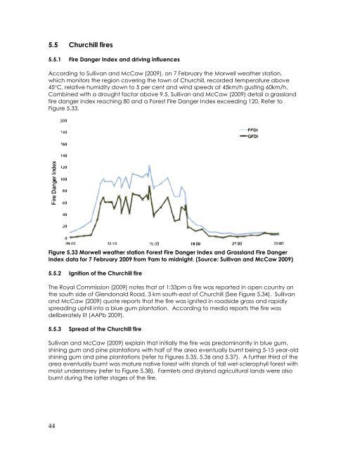
5.5 Churchill fires5.5.1 Fire Danger Index and driving influencesAccording to Sullivan and McCaw (2009), on 7 February the Morwell weather station,which monitors the region covering the town of Churchill, recorded temperature above45°C, relative humidity down to 5 per cent and wind speeds at 45km/h gusting 60km/h.Combined with a drought factor above 9.5, Sullivan and McCaw (2009) detail a grasslandfire danger index reaching 80 and a Forest Fire Danger Index exceeding 120. Refer toFigure 5.33.Figure 5.33 Morwell weather station Forest Fire Danger Index and Grassland Fire DangerIndex data for 7 February 2009 from 9am to midnight. (Source: Sullivan and McCaw 2009)5.5.2 Ignition of the Churchill fireThe Royal Commission (2009) notes that at 1:33pm a fire was reported in open country onthe south side of Glendonald Road, 3 km south-east of Churchill (See Figure 5.34). Sullivanand McCaw (2009) quote reports that the fire was ignited in roadside grass and rapidlyspreading uphill into a blue gum plantation. According to media reports the fire wasdeliberately lit (AAPb 2009).5.5.3 Spread of the Churchill fireSullivan and McCaw (2009) explain that initially the fire was predominantly in blue gum,shining gum and pine plantations with half of the area eventually burnt being 5-15 year-oldshining gum and pine plantations (refer to Figures 5.35, 5.36 and 5.37). A further third of thearea eventually burnt was mature native forest with stands of tall wet-sclerophyll forest withmoist understorey (refer to Figure 5.38). Farmlets and dryland agricultural lands were alsoburnt during the latter stages of the fire.44