Eglwyseg - Clwyd-Powys Archaeological Trust
Eglwyseg - Clwyd-Powys Archaeological Trust
Eglwyseg - Clwyd-Powys Archaeological Trust

Create successful ePaper yourself
Turn your PDF publications into a flip-book with our unique Google optimized e-Paper software.
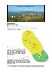
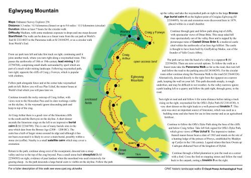
<strong>Eglwyseg</strong> MountainMaps Ordnance Survey Explorer 256Distance 5.3 miles / 8.5 kilometres (linear) or up to 9.6 miles / 15.5 kilometres (circular)Duration Allow at least 7 hours for the circular walkDifficulty Medium, with some moderate exposure to drops and one steep descentStart/finish The walk can be done as a linear route from the car park at World’sEnd SJ 23214835 to the Panorama walk at SJ 24104295, or as a circular walkfrom World’s End.From car park turn left and take first track on right, continuing until itjoins another track, where you turn right along a waymarked route. Thispasses the earthworks of 18th or 19th-century lead mining 1 (SJ23794768), comprising small shafts surrounded by spoil which arepart of a much wider mining landscape. Following waymarked path,turn right, opposite the cliffs of Craig y Forwyn, which is popularwith climbers.Follow path alongside fence and at the corner take waymarkedpath on left. Below you will see Plas Uchaf, the manor house atWorld’s End which you will pass later on.Continue towards the rocky outcrop of Craig Arthur, withviews west to the Horseshoe Pass and its slate workings visibleon the skyline. At the waymark ignore descending path andkeep to top of the crag.At Craig Arthur there is a good view of the limestone cliffsto the south and the Berwyns on the skyline. A short detourascends the limestone crags on the left to an impressive burialcairn 2 (SJ 22344708). This is one of many burials sites in thearea which date from the Bronze Age (2300 – 1200 BC). Thecairn has a kerb of larger stones around its edge and although it hasnot been excavated it is likely to cover a main burial, possibly within astone cist (coffin). Nearby is a small satellite cairn which may cover acremation.Return to the path, continue along crest of the escarpment, descend into a steepvalley and rise to the top of the crag beyond. Pass a small stone-built sheepfold 3 (SJ22304583) on right, evidence of past landuse when the moorland was used extensively forgrazing sheep. As the path descends a large burial cairn is visible on the skyline. Follow the pathFor a fuller description of this walk see www.cpat.org.uk/walksup the valley and take the waymarked path on right to the large BronzeAge burial cairn 4 on the highest point of Creigiau <strong>Eglwyseg</strong> (SJ22184495). An urn and cremation were discovered here in 1879,placed within in a small chamber.Continue through gate and follow path along top of cliffs,with spectacular views of Dinas Brân. This steep sided hillrises spectacularly out of the valley floor and is topped by thepicturesque ruins of Castell Dinas Brân 5, a medieval castlesited within the earthworks of an Iron Age hillfort. The castleis thought to have been built by Gruffydd ap Madoc, son of thefounder of Valle Crucis Abbey.The path curves into the head of a valley to a signpost 6 (SJ22554420). There are now several options. To follow the walk as alinear route take the Panorama Walk as far as the road, then turn leftand follow the road to the parking area (SJ 24104295). For the circularroute either continue along the Panorama Walk to the road (SJ 23644324).Alternatively, descend directly to the right from the signpost on a narrowpath, keeping the wall on your left. This path descends steeply, is roughunderfoot, and may be difficult in wet weather. As the valley narrows ignorea path leading left to a quarry and follow the path right, through gorse, to theroad.Turn right at road and and follow it for some distance before taking a trackrising on the right, waymarked for the Offa’s Dyke Path (SJ 21814530). Avery short detour on the right leads to a well-preserved limekiln 7. Thisarea was once an important source of limestone, which was used as abuilding stone and also burnt for use in lime mortar and as an agriculturalfertilizer.Continue to follow the Offa’s Dyke Path along the base of the cliffsand below Craig Arthur. Take left fork signed for Offa’s Dyke Path,which gives views of Plas Uchaf 8. The impressive timberframedmanor house bears a date of 1563 and stands on the site ofa hunting lodge of the princes of <strong>Powys</strong>, established by Bleddynap Cynfyn in the 11th century. Legend relates that here Owain apCadwgan abducted Nest of the kingdom of Dyfed.Continue through a felled plantation to join the road on a cornerwith a ford. Cross the ford on stepping stones and follow the roadback to the carpark, noting a limekiln 9 on the right.CPAT historic landscape walks © <strong>Clwyd</strong>-<strong>Powys</strong> <strong>Archaeological</strong> <strong>Trust</strong>