Spring 2007 issue - Clwyd-Powys Archaeological Trust
Spring 2007 issue - Clwyd-Powys Archaeological Trust
Spring 2007 issue - Clwyd-Powys Archaeological Trust
- No tags were found...

You also want an ePaper? Increase the reach of your titles
YUMPU automatically turns print PDFs into web optimized ePapers that Google loves.
CLWYD-POWYS ARCHAEOLOGICAL TRUSTPhoto: CPAT 05-C-096newsletter<strong>Spring</strong> <strong>2007</strong>1
IntroOur <strong>Spring</strong> <strong>2007</strong> Newsletter looks at some of the work carried out by the <strong>Clwyd</strong>-<strong>Powys</strong><strong>Archaeological</strong> <strong>Trust</strong> over the last year or so. In many cases you can find moreinformation on the items on our website (www.cpat.org.uk). More recent stories mayappear in our online newsletter (www.cpat.org.uk/news/news.htm).The <strong>Trust</strong> is a voluntary organisation employing a small professional staff involvedwith many aspects of the heritage in mid and north-east Wales. We work closely withmany other organisations, including Conwy, Denbighshire, Flintshire, <strong>Powys</strong> andWrexham county councils, Brecon Beacons National Park, Cadw and other departmentsof the Welsh Assembly Government, the Royal Commission on the Ancient HistoricalMonuments of Wales, the Countryside Council for Wales, the National Museum ofWales, as well as many local societies interested in the archaeology of our area.The <strong>Trust</strong> maintains a record of archaeological information for the <strong>Clwyd</strong>-<strong>Powys</strong> area(the Historic Environment Record), provides information and advice on the managementand conservation of archaeological sites, and carries out survey and excavation projects.Photo: CPAT 1766-0050© The <strong>Clwyd</strong>-<strong>Powys</strong> <strong>Archaeological</strong> <strong>Trust</strong>7a Church Street, Welshpool, <strong>Powys</strong>, SY21 7DLtel 01938 553670, fax 01938 552179email trust@cpat.org.uk, website www.cpat.org.ukRegistered Charity 50830, Limited Company 1212455Thomas Telford’s Pontcysyllte Aqueduct,Wrexham, forms part of the Vale ofLlangollen and Eglwyseg historiclandscape. For further information visit,www.cpat.org.uk/projects/longer/histland/histland.htm2
Dyffryn Lane henge dig 2006During the long hot summer in 2006 the <strong>Trust</strong> was busy on a joint project with staff andstudents from the Department of Archaeology of the University of Bradford, looking atparts of a fascinating complex of prehistoric ritual monuments at Dyffryn Lane, close tothe river Severn near Berriew, south of Welshpool.At this point the Severn winds slowly down a broad valley, confined by quite steepslopes on either side and dominated by the isolated massif of the Breiddins to the north.The area seems to have held considerable attraction to the people of the later Stone Ageand the Bronze Age. Great numbers of monuments were built and used here over a periodlonger than has passed since the Romans left Britain. In the four to five thousand yearssince their construction, these once-impressive earth, timber and stone monuments havemelted back into the countryside, effectively forgotten until their rediscovery by aerialreconnaissance.The gradual revelation of a remarkable wealth of prehistoric ceremonial and funerarymonuments along the Severn valley south of Welshpool is of special interest, partlybecause of the relative rarity of these kinds of monuments but also because of what theirpresence here says about the spiritual or social significance of this area to prehistoricpeople.Photo: CPAT 1766-0050; 86-C-0119Above Cropmark aerial photograph ofthe Dyffryn Lane henge monument. Theditch appears as a dark circle, with anentrance to the left.Right The Maen Beuno standing stonestands in the road verge along DyffrynLane, near the henge monument.3
Excavations in progress in July 2006 on the site of the Dyffryn Lane hengemonument. The henge ditch shows as a dark circular grass-mark in the field andcan just be seen as a darker soil-mark inside the excavated areaPhoto: © Chris MussonTo either side of Dyffryn Lane lies a complex of monuments that would have been adominant part of the Neolithic and Bronze Age landscape and of the lives of the peopleliving here for many hundreds of years. The oldest sites are a Neolithic long barrow anda nearby enclosure, both of which are known to have been built five and a half thousandyears ago, in about 3500 BC. Later, the complex appears to be focused on a type ofenclosure known as a henge monument (named after Stonehenge) consisting of a largecircular ditch with a single entrance and an outer bank of which only a handful of similarexamples are known elsewhere in Wales. A cluster of prehistoric burial mounds surroundthe henge.The Dyffryn Lane henge appears to have had a particularly long and complex history.Parts of a stone circle were revealed in the centre of the site in the middle of the nineteenthcentury when a number of trenches were dug by a local antiquarian, D. Phillips Lewis,who had been told of the farmer’s intention of removing stones ‘which had so ofteninterfered with the free passage of his plough’. An earthen mound had also, unusually,been built in the centre of the site. In Phillips Lewis’s day the mound was said to havebeen ‘eight or nine feet above the field’ but has since then been lowered by ploughing to4
no more than a quarter of this height. The standing stone known as Maen Beuno whichhas long lain in the nearby road verge seems likely to have formed part of the hengecomplex.The Dyffryn Lane project aimed to unravel the order in which the various elements at thesite had been built, to recover dating evidence and evidence about the environment inwhich the monuments were built, and to evaluate the effects of continued ploughing.The project, which included a programme of trial excavation, topographical survey andgeophysical survey, was carried out in under the direction of Dr Alex Gibson of theDepartment of <strong>Archaeological</strong> Sciences in the University of Bradford with grant aid fromCadw. The project was also designed to form part of the undergraduate course for Alex’sarchaeological students, by providing practical experience of a variety of excavation andsurvey techniques.The henge monument was found to consist of a number of distinct elements includingthe central mound about 20 metres in diameter, a stone circle about 10 metres in diameter,Photo: CPAT 2159-096Archaeology students from the University of Bradford and <strong>Trust</strong> staff at work in themiddle of the henge monument, uncovering some of the stones of the original stonecircle.5
the low outer bank and 2-metre deep hengeditch, as well a central pit, buried turf-linesbelow the central mound, and a series ofearlier pits and other features.An important discovery was made as thestudents cleaned back over the outer bank,revealing a concentration of sherds ofNeolithic coarse pottery of a type knownas Peterborough Ware, which came from ashallow pit. The pit also contained charredorganic material including hazelnut shells,as did two other small pits nearby. Otherfinds from the site include some fine piecesof worked flint, including a Bronze Agebarbed-and-tanged arrowhead found in thecentral mound.Photos: CPAT 2155-66, -70Above Sealed deposits at the site werecarefully sieved to recover charcoal andother carbonised plant remains toprovide samples for radiocarbon datingand to provide information about thetrees and plants growing in the area inprehistory.Below Sherds of Neolithic potteryknown as Peterborough Ware found atthe henge monument.Work has already begun on analysing thevarious finds and samples recovered duringexcavation, the results of which will bepulished in due course. A preliminary seriesof radiocarbon dates obtained from the BetaAnalytic Radiocarbon Dating Laboratoryin Miami, Florida, suggest that the hengemonument was built after about 2800-2500BC and that the central mound was builtafter about 2600-2300 BC.For further information about theDyffryn Lane henge dig visitwww.cpat.org.uk/news/news.htm6
Down the mines . . .One of the walks by the <strong>Trust</strong> to placesarchaeologial interest in 2006 looked at theCwm Elan Lead Mine, west of the GarregdduReservoir, organised for members ofthe Cambrian Mountain Society and theElan Valley <strong>Trust</strong>.Lead mining first began here in the 1790sfollowing the accidental discovery of leadore by workmen digging ditches. Most ofthe visible remains, however, belong to the1870s when new investments were madeby the mining company. Mining came toan abrupt end when the Elan Valley waspurchased in the 1890s for the BirminghamCorporation reservoir scheme, in order topreserve the purity of the water supply.For further information on metal minesin the <strong>Clwyd</strong>-<strong>Powys</strong> area visitwww.cpat.org.uk/projects/longer/mines/mines.htmAbove One of the waterwheel pits at theCwm Elan lead mine, during earliersurvey work by the <strong>Trust</strong>.Below Looking out across the formerCwm Elan mine sett during one of thehistoric landscape walks organisedduring 2006.Photos: © Liz Fleming-Williams; CPAT 283-357
National Archaeology Week2006Great fun was had by all on Saturday 15 July at the <strong>Powys</strong>landMuseum in Welshpool. Children of all ages enjoyed thevarious activities, which included dressing up in Romanoutfits, exavating and identifying finds from sand boxes,reconstructing Roman pots and tiles, writing on Roman waxtablets and creating their own ‘cropmarks’ using seed trays,gravel and cress!As well as the <strong>Powys</strong>land Museum’s permanent displaysand temporary exhibition, a range of Roman finds werebrought out from behind glass for handling by anyone whowanted a closer look. These included pottery, animal bone,glass objects, brooches and coins.Photo: CPAT 2161-013, -018, -020On the following Monday staff of the <strong>Trust</strong> and <strong>Powys</strong>landMuseum visited Llanidloes Primary School. In a combinationof assemblies and group activities we worked with all childrenfrom Years 3 to 6. The day was a great success and somethingLeft YAC memberChristopher Cole (10).Below Andre Peate, anavid Time Team fan.8
which we would hope to do in years to come, hopefully moving around differentschools.Young Archaeologists’ ClubKids aged between 8 and 16 can join the Young Archaeologists’ Club (YAC) . Thereare several branches in Wales, but if there are none near you, you can still join the cluband receive the magazine four times a year and enter competitions including theannual ‘Young Archaeologist of the Year Award’.For further information about the Young Archaeologists Club visitwww.britarch.ac.uk/yac/index.htmlBrothers Andre (5) and Louis (4) Peate dressed as Roman soldiers.9
Historic ports and harboursThe north-east Wales coast and the Dee Estuary in Denbighshire and Flintshire has arich legacy of small ports and harbours which are important to our understanding of thehistory of transport, trade and industry in this area from Roman and medieval times upto the coming of the railways in the second half of the nineteenth century.With support from Cadw the <strong>Trust</strong> has been carrying out a detailed assessment of thepotentially significant upstanding or buried remains associated with a number of themore important historic sites—such as Rhuddlan, Foryd, Talacre, Llannerch-y-môr,Greenfield, Bagillt, Flint, Connah’s Quay, Queensferry and Sandycroft—to provide abaseline from which to develop future management strategies.It is likely that the Roman coastal settlements at Prestatyn and Flint were associatedwith active trade along the coast to Chester, though direct evidence of this still awaitsdiscovery. During the medieval period the medieval towns at Flint and Rhuddlan bothhad active trading ports.By the middle of the fifteenth century silting in the Dee estuary was already becominga problem. By the sixteenth century recommendations were being made for the diggingPhoto: CPAT 06-C-316Above Dockside facilities at Connah’s Quay, Flintshire, began in the late eighteenthcentury in conjunction with a tramway carrying coal from the Northop collieries.Passenger services to Llandudno and Chester developed in the 1860s.Photo: CPAT 2079-03110
Llannerch-y-môr Quay,Denbighshire was set upto serve the nearbyleadworks. The Duke ofLancaster, a former Isle ofMan ferry, now liesabandoned at the mouthof the inlet.of a navigable chanel along the Flintshireshore to provide deep water navigation toChester. It was not until 1737, however, thatthe New Cut was eventually dug whichlead to a revival in coastal traffic along theDee. It was also directly responsible forthe birth of Saltney, Sandycroft,Queensferry and Connah’s Quay, whichhandled the export of coal and minerals toports elsewhere in Britain and Europe.The development of the railway networkduring the second half of the nineteenthcentury gave a spur to further expansionfor most of the ports along the coast ofnorth Wales, especially at Connah’s Quayand Mostyn. Rhuddlan began to declinein importance as a port, however, due tosilting of the river <strong>Clwyd</strong>. This led to theemergence of the harbour at Foryd at theriver estuary.With the exception of Rhuddlan, the portswere at their busiest during the latenineteenth and early twentieth centuries.The subsequent decline in the local coal,lead, brick, engineering and shipbuildingindustries led to the closure of all of thesmaller ports. Connah’s Quay remainsactive, but is a shadow of its former self.Only Mostyn has survived as a major port,and indeed has somewhat ironically recentexpanded due to the growth in air travel! Ithandles the export of wings produced bythe European Airbus factory at Broughton.For further information about historicports and hoarbours visitwww.cpat.org.uk/projects/longer/ports/ports.htm11
Pen-y-crug near Brecon, one of the magnificently wellpreservedIron Age hillforts surviving in Wales and theborderland. The larger hillforts probably represent tribalcentres, in this instance probably belonging to theSilures who we know from Roman writers occupied thispart of south Wales (for further information seewww.cpat.org.uk/projects/longer/histland/usk/12
Iron Age villages and farmsDuring the last couple of years the <strong>Trust</strong> has been engaged in a project with Cadwtrying to ensure the continued preservation of so-called ‘defended enclosures’throughout the <strong>Clwyd</strong>-<strong>Powys</strong> area. These are generally types of sites that we think ofas belonging to the Iron Age—the period between about 700 BC and the Roman conquestin about AD 60, though some began life in the preceding Bronze Age if not earlier, andothers continued in use during the Roman period and beyond.The defended enclosures were protected by banks and ditches and probably enhancedin some cases by stone revetment walls or timber palisades. At the big end of the scaleare sites like Penycloddiau hillfort, shown below, enclosing many hectares and set ontop of impregnable hilltops. These larger sites could accommodate many hundreds ofpeople together with their animals and belongings, and most probably represent tribalcentres. At the other end of the scale are much smaller sites, often sited on much lowerlyingground, representing farmsteads which probably only housed only single families.The hilltop sites are often well preserved, with clearly defined defences, but aresometimes under threat from pasture improvement or afforestation. The defences ofmany of the smaller, low-lying siteshave been ploughed down over thecenturies and are often only knownfrom cropmark aerial photography orfrom geophysical survey, and mayvulnerable to damage by ploughingor by building development.Above Penycloddiau hillfort on the<strong>Clwyd</strong>ian range in Denbighshire.Photo: CPAT 05-C-141Below Geophysical survey of arecently-discovered enclosure onthe banks of the river Severn atDol-las near Berriew, now invisibleon the surface of the ground. Thedarker marks show inner and outerenclosure ditches with entrancegaps towards the bottom of thepicture. Curving ditches inside theinner ditch were probably drainageditches which encircledroundhouses.CPAT 2006; Photo: CPAT 84-C-027113
Throwing light on the Dark AgesBecause of the relative lack of written records, the period between the end of Romanrule in about AD 410 and the Norman Conquest in 1066 is often known as ‘The DarkAges’. It was clearly a dynamic period, however, which witnessed the emergence ofWales as a separate identity and the creation of the early kingdoms that were to play animportant role in Welsh history throughout the Middle Ages. The dearth of writtenrecords during this period means that archaeology has a particularly important role toplay in fleshing out the bare bones of the historical record.One of the best-known monuments of the period is the bank and ditch running alongthe boundary between England and Wales built by Offa, the Anglo-Saxon king of Mercia,before his death in AD 796. Much less well known is the pattern of much shorter dykesalong the Welsh borderlands which have sometimes been thought of as belonging tothe Dark Ages. Recent work by the <strong>Trust</strong> with the support of funding by Cadw has forthe first time provided definite proof that this is indeed the case. Small-scale excavationsat five dykes in <strong>Powys</strong>—Clawdd Mawr, Crugyn Bank, Upper Short Ditch, Giant’s Graveand the Short Ditch—have provided samples for radiocarbon dating, showing that theywere constructed most likely in the period between AD 450–750, the critical periodduring which the early Welsh kingdoms were forged. These shorter dykes seemed tohave played a significant important role in defining these early territorial divisions.Crugyn Bank dyke cuts across the hills south of Dolfor close to the southernboundary of the former county of Montgomeryshire. Organic samples from belowthe bank have been shown to date to the period AD 650–780.Photo: CPAT 87-MB-117914
Photo: CPAT 92-MB-0053The Short Ditch, shown here under snow, running through woodland, cutsacross the saddle of the hill south of Beguildy. Charred material recoveredfrom below the bank shows that it was built in the period AD 410–590.15
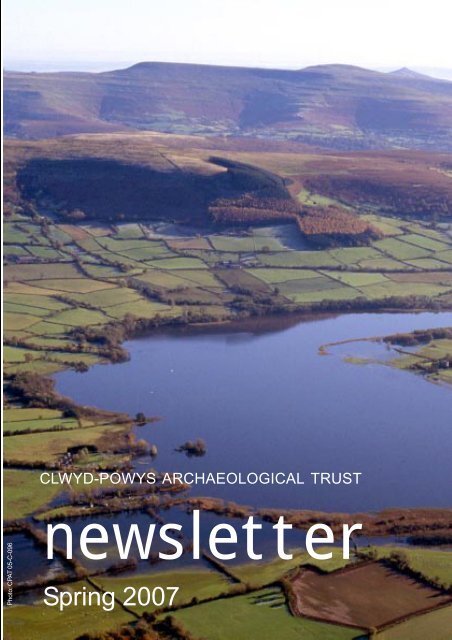
Welsh Historic LandscapesMany cherished Welsh landscapes have been shaped directly or indirectly by humanactivity over the course of the many thousands of years. Even those parts of thecountryside that we think of as beingsomehow ‘natural’ often preserve adetailed record of past ways of life.A number of landscapes of outstanding orspecial historic interest in Wales aredescribed in two Historic LandscapeRegisters. Since the registers werepublished a few years ago we have beentrying to identify in greater detail thehistoric elements that make up theselandscapes, defining a number ofdistinctive ‘historic landscape characterareas’ within each landscape.One of the landscapes the <strong>Trust</strong> has beenlooking at in this was is what is called theMiddle Usk Valley, between Brecon andTalybont-on-Usk. Some of the distinctivecharacter areas in this historic landscapeare shown alongside, which include (fromtop to bottom) the river meanders on theUsk near Scethrog, the centre of the villageof early medieval origin at Llanddew, fieldsystems of medieval origin near Llanddew,and the town of medieval origin at Brecon.For further details on historic landscapesvisit www.cpat.org.uk/projects/longer/histland/histland.htmFront cover Llangors lake in southern<strong>Powys</strong> with the Black Mountainsbeyond, forms part of the Middle UskValley historic landscape. The lake, is arich source of local legends and was thesite of an important royal settlement ofthe early medieval kingdom ofBrycheiniog, built on an artificialisland (crannog) in the lake.16