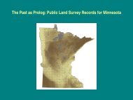
Minnesota Public Land Surveys; A Geographer's Perspective
Minnesota Public Land Surveys; A Geographer's Perspective
Minnesota Public Land Surveys; A Geographer's Perspective
- No tags were found...

Create successful ePaper yourself
Turn your PDF publications into a flip-book with our unique Google optimized e-Paper software.
<strong>Minnesota</strong> <strong>Public</strong> <strong>Land</strong> <strong>Surveys</strong>; A Geographer’s <strong>Perspective</strong>Rod Squires, University of <strong>Minnesota</strong>
“A Striking Example of Geometry Triumphant over PhysicalGeography”“The Immaculate Grid”
For years I have performed a balancing act betweenDetail necessary to describe and explain thepublic land surveys to land surveyors of<strong>Minnesota</strong>• of limited geographical applicabilityAn Inventory of the <strong>Public</strong> <strong>Land</strong> <strong>Surveys</strong> Recordsfor <strong>Minnesota</strong>: The Special InstructionsGeneralizations to provide an overview of thesurveying effort throughout the United States1785-1925 to non-surveyors• take the surveying efforts for granted• interested only in the outcome of the surveys
To connect the various spatial scales thathave occupied my attention1866
The rectangular public land survey net is one of the mostvisible yet least understood cultural landscape feature in theUnited StatesCreated legal descriptions; but imposed a spatialframe of reference on virtually all human activities inthe United States
The <strong>Public</strong> <strong>Land</strong> <strong>Surveys</strong> in a National SettingWhere the surveys spread and wherethey did notContinuing Relevance of the Points andLines<strong>Land</strong> Act of February 11, 1805 (2 Stat. 313)All the corners marked in the surveys, returnedby the surveyor-general …shall be establishedas the proper corners, of the sections, orsubdivisions of sections, which they wereintended to designate ….The boundary lines, actually run and marked inthe surveys returned by the surveyor-general…shall be established as the proper boundarylines of the sections, or subdivisions, for whichthey were intended ….
<strong>Public</strong> <strong>Land</strong> Survey CharacteristicsTurns out that some of them are not asnational as might at first appearWhat is national – of less interest to surveyors• The geometric figures that defined theboundaries of land parcels – mostlyubiquitous – if not always “square”• The principal meridians and baselines –mostly ubiquitous• The correction lines, standard parallels, andguide meridians – not ubiquitous• Purpose – providing a "legal description" ofthe land the federal government wouldprivatize• Mapping – township plats containinginformation relevant to prospectivelandowners• Operationally – carried out by a cadre ofdeputy surveyors under contract with aSurveyor General and financed byCongressional appropriations
<strong>Land</strong> System Legal SystemThe <strong>Land</strong> Ordinance, 1785The Northwest Ordinance, 1787• <strong>Land</strong>s north and west of the RiverOhio ceded by Native Americanswould be subdivided in an orderlymanner• The United States would convey titleto these lands to individuals – asection in each township would bereserved• Original government and politicalevolution – jurisdiction over land andindividuals vested in a nationalgovernment – to be subsequentlyshared with a state government – “onan equal footing”• Individuals acquiring title guaranteedtheir rights
<strong>Land</strong> SystemLegal SystemFederal StatutesNative American <strong>Land</strong> Cessions<strong>Public</strong> <strong>Land</strong> <strong>Surveys</strong>Territory<strong>Public</strong> <strong>Land</strong> ConveyancesCounty<strong>Land</strong>owners in <strong>Minnesota</strong> Territory<strong>Land</strong>owners in <strong>Minnesota</strong>County
Two characteristics allowed the surveys to be carried in widelyseparated localities1. A technical element that was independent of the other details of the rectangular net– established when necessary – provided basic surveying control and locationalcontrol
Two characteristics allowed the surveys to be carried in widelyseparated localities2. An administrative system comprising statutorily defined surveying districts andPresidentially appointed surveyors general – established when necessary• Considerable independence from each other – how much?• Appropriations from Congress – annual and deficiency• Funds apportioned by the Commissioner of the General <strong>Land</strong> Office to eachsurveyor general, along with “annual instructions”
Paper Trail
Administration of the <strong>Public</strong> <strong>Land</strong> <strong>Surveys</strong>May 18, 1796 (1 Stat. 464-469)Be it enacted by the Senate and House of Representatives of the United States ofAmerica, in Congress assembled,That a Surveyor General shall be appointed, with the authority… to engage a sufficient number of skilful surveyors, as his deputies,… he shall have authority to frame regulations and instructions for thegovernment of his deputies… to survey and mark the unascertained outlines of the lands lying northwest ofthe river Ohio, and above the mouth of the river Kentucky… in which the titles of the Indian tribes have been extinguished
Atlantic <strong>Surveys</strong> 1785 - 1851
Atlantic Surveying Districts – surveys completed by 1851NorthernOhio, Michigan, Indiana, Illinois, Wisconsin,Arkansas, Missouri, Iowa, <strong>Minnesota</strong>Related administratively through theSurveyor General of the Northwestestablished in 1796SouthernMississippi, Alabama, Louisiana, FloridaRelated administratively through theSurveyor South of Tennessee established in1803Ohio, Michigan, Indiana 1796 -1857Missouri & Illinois 1803 -1863Arkansas 1832 -1859Wisconsin & Iowa 1838 -1866<strong>Minnesota</strong> 1857- 1908Mississippi 1803- 1849Alabama 1817- 1849Louisiana 1831- 1909Florida 1824 -1908
Pacific <strong>Surveys</strong> 1851-1925
Pacific Surveying DistrictsCalifornia 1851-1925Oregon 1851-1925Washington 1854-1925Kansas & Nebraska 1854-1925New Mexico 1854-1925Utah 1855-1925Colorado 1861-1925Arizona 1863-1925Nevada 1861-1925Idaho 1866-1925Montana 1867-1925South Dakota 1861-1925Wyoming 1890-1925North Dakota 1890-1925
Standardized InstructionsIn 1851 the Oregon Manual of Surveying Instructions was issued• Initially controlled the surveys carried out in the newly established Pacific surveyingdistricts of Oregon Territory and California• Subsequently made applicable to the existing Atlantic surveying districts ofWisconsin and Iowa including <strong>Minnesota</strong> Territory – and perhaps Louisiana andArkansas• Subsequently made applicable to the new Pacific surveying districts of Kansas andNebraska, New Mexico, and Washington1855 republication made applicable to all existing and all subsequent surveyingdistricts – made part of every surveying contract in 1862
<strong>Minnesota</strong> shows characteristics of both Atlantic and Pacificsurveys
Instructions for <strong>Minnesota</strong> TerritoryBefore 1852 After 1852Commissioner of the General <strong>Land</strong> OfficeInstructionsInstructions GeneralSurveyor GeneralGeneralSpecialSpecialDeputy Surveyor
Why should we care about how the surveys were administered?
<strong>Minnesota</strong> State Archives. St. Paul
<strong>Minnesota</strong> Historical Society
National Archives Washington D.C.
Evidence for the <strong>Public</strong> <strong>Land</strong> <strong>Surveys</strong>
Still a Lot to be Learned about NotebooksLegend of map published with annual report of surveyor general
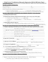
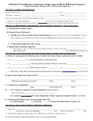
Township Plats – drawn at ascale of two inches per mileDescriptive Lists
Township Exterior Diagrams
Independent Meridian
1847
1852
1856 William Burt
Townships bordering the St. Croix
History of the Rectangular Survey SystemC. Albert White’s Contributions
Conclusion 1.I could not have described the historical geography of the public land surveys withoutunderstanding the details of the surveying process – particularly how the surveyswere administered
Conclusion 2.I am not sure modern land surveyors can entirely understand the details of the publicland survey lines they retrace and the points they remonument without a broadgeographical and historical perspective