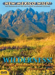
WildernessProtection - New Mexico Wilderness Alliance
WildernessProtection - New Mexico Wilderness Alliance
WildernessProtection - New Mexico Wilderness Alliance
- No tags were found...

You also want an ePaper? Increase the reach of your titles
YUMPU automatically turns print PDFs into web optimized ePapers that Google loves.
ABQ AreaWith the longer days and warmingweather, we will nowmeet at 7:00am at our offi ce parkinglot on the SW corner of Centraland Broadway. Dress appropriatelyfor the weather and bring extrawear needed for weather and elevationchanges. Bring water, lunch,and enough munchies for the day.We will figure out the car pool situationin the parking lot (if you arewilling to drive, it is greatly appreciated).Our aim will be to have youback by 7:00pm, usually earlier.All hikes subject to change due toweather or fi re restrictions.August 1st:Sandia Mountain <strong>Wilderness</strong>, PiedraLisa TrailThe Piedra Lisa Spring Trail beginsin Cholla and Juniper and goes from6,120 feet to 8,200 feet. The hikeis moderate to strenuous due to a2,100 foot elevation gain within a 2mile stretch of trail. We will followthe trail up to the Rincon saddlethat comes off the shield. The viewfrom the saddle is spectacular! Afterenjoying the view, we will continueon down into the valley below. Thevalley has wonderful diversity inits plants and wildlife. Older childrenwho enjoy hiking are able tohike this trail, and there are severallovely spots to stop and restalong the way. Contact Hike Leaders,Tanya Critchfi eld at 505-244-4059 (Events@LosPoblanos.com)or Nathan <strong>New</strong>comer at 505-843-8696 (nathan@nmwild.org).Distance: 6 - 7 miles round-tripTime: 4 – 5 hours round-tripElevation Gain: 6,120 to 8,200 feetDifficulty: Moderate to StrenuousAugust 7th:Sandia Mountain <strong>Wilderness</strong>,Three Guns Spring TrailWe start Three Gun Springs trailin a large, bowl shaped, southfacing canyon featuring diverseUpper Sonoran Zone vegetationand climb into Transition Zone Forestspast occasional riparian corridorsshaded by Douglas fi r. Viewsexpand out across Albuquerque toMt. Taylor. We meet Embudito trailat Oso Pass, a large saddle withgreat views north and south alongthe Sandia <strong>Wilderness</strong>’s wholelength. We descend down a deepcanyon with a well-developed ripariancorridor fi lled with huge treesand slowly reach the high desertback at the cars. Contact HikeLeader, Mike Ritchie at 505-255-1016 or mrichie@comcast.net formore information.Distance: 8 miles round-tripTime: 4 hours round-tripElevation Range:6,200 to 8,400 feetDifficulty: ModerateAugust 21st: Pecos Mountain <strong>Wilderness</strong>,Nambe LakeWe descend gently on the Winsortrail into the Pecos <strong>Wilderness</strong> forabout 2 miles to the steep turnoff up to alpine Nambe Lake. Theroute climbs along the Rio Nambethrough several verdant, wild flowerfi lled meadows past spruce / fir andaspen stands to picturesque NambeLake. Nestled below timberlinein a rocky cirque between LakePeak and Santa Fe Baldy the crystalclear waters reflect the colors ofsky, clouds, rocks and forests. We’llrelax on the shoreline and possiblydo a little scrambling beforeour descent. Contact Hike Leader,Mike Ritchie at 505-255-1016 ormrichie@comcast.net for moreinformation.Distance: 6 miles round-tripTime: 4-5 hours round-tripElevation range: 10,200to 11,400 feetDifficulty: Moderate to StrenuousSeptember 12th:Manzano Mountain <strong>Wilderness</strong>, TrigoCanyonThe Trigo Canyon Trail begins onthe western slopes of the ManzanoMountains at the John F. Kennedycampground and crosses anintermittent stream before ascendingthrough a canyon full of numerouslarge alligator junipers. At 2.5miles, the trail passes a shallowcave and then several waterfalls.The trail then switchbacks up thecanyons north side and meandersup a pleasant forested valley. Atabout four miles, the trail leaves thestream and passes through a ponderosaforest before topping outat a beautiful knoll with spectacularviews to the north. Contact HikeLeader, Nathan <strong>New</strong>comer at 505-843-8696 or nathan@nmwild.orgfor more information.Distance: 8 miles round-tripTime: 4 to 6 hours round-tripElevation Range: 6,250 to 8,800 feetDifficulty: Moderate to StrenuousSeptember 26th:Ojito <strong>Wilderness</strong> Study AreaWe will walk into the heart of theOjito badlands approaching eitherfrom the east or west depending onroad conditions. Rainbow bandedmesas guard natural sculpture gardensfilled with amusing hoo doosof all sizes and shapes. Twistedold junipers and dwarf ponderosaadd a touch of green to the fantastic,multi-colored rock forms.There are no trails and the crosscountrytrek involves lots of scramblingand path finding down windingwashes and up to picturesquemesa tops with panoramic highdesert views. Contact Hike Leader,Mike Ritchie at 505-255-1016 ormrichie@comcast.net for moreinformation.Distance: Depends on route andgroup decision (3-6 miles)Time: Same as above (3-5 hours)Elevation Range: 5,800 to 6,000 feetDifficulty: ModerateOctober 9th Weekend: Withington<strong>Wilderness</strong> Outing in the San MateoMountainsAfter a long 4X4 drive, we’ll arriveat our trailhead campsite at 9,800feet in the early afternoon andtake a short warm up hike downto impressive rock formations inChimney Canyon. Next morning weleave early for our hike down intoPotato Canyon. The trail is very difficultto follow once we reach themaze of side canyons and soaringrock walls sheltering lush ripariangardens in the canyon depths.The box elders and oaks shouldbe sporting fall foliage and thestreams and small waterfalls shouldbe flowing. Contact Hike Leader,Mike Ritchie at 505-255-1016 ormrichie@comcast.net for moreinformation.Distance: Total with both hikes 10-12milesTime: Total time, full dayElevation range: 9,800 to 7,000 feetDifficulty: Strenuous to ModerateSouthern NMContact Trisha London in NMWA’sLas Cruces office for information on allthe following hikes, including how toget there and back. You can reach herat 505-527-9962.July 10th: Emory PassThis is a moderately strenuous hikejust inside the boundary of the AldoLeopold <strong>Wilderness</strong>. The hike offerssome great views of the Black Range.If you go all the way to the peak it’s9 miles round trip, otherwise wecoulddo about 6 miles round trip.August 14th: Three RiversThis hike makes for a long day butis worth it! We’ll be hiking along astream through the forest with hundredsof petroglyphs to enjoy alongthe way. The trail is steep in certainsections, but otherwise is a moderatelystrenuous hike. We’ll do a 5-6 mile round trip hike, but for thosewanting to go all the way to the crestit’s a 12 mile round trip.August 20th - 22nd: Peloncillo MtnsRoads InventoryThe Sky Island <strong>Alliance</strong> (SIA) ofTucson is hosting this volunteeropportunity to help inventory part ofthe Peloncillo Mountains in the southwestcorner of <strong>New</strong> <strong>Mexico</strong>. This is arare chance to see parts of the privatelands in this region. Space is limited,call Trevor Hare of SIA at (520) 624-7080.September 25th: Apache KidThis is an fairly strenuous hike. We’llbe starting at Springtime Campgroundto the southeast of San Mateo Peak.At 2 to 3 miles in, you get great viewstoward the Rio Grande Valley. Forthose who hike to San Mateo Peak,it’s a very strenuous 8 mile round trip.October 9th: Organ MountainsWe’ll be hiking Pine Tree Trail whichis about a 4 3/4 mile moderatelystrenuous “loop” hike. Really goodviews to be had as the trail circlesaround the base of the “needles”.<strong>New</strong> <strong>Mexico</strong> WILD!Page 15