hbmp annual report 2008 part 3 - CHNEP.WaterAtlas.org
hbmp annual report 2008 part 3 - CHNEP.WaterAtlas.org
hbmp annual report 2008 part 3 - CHNEP.WaterAtlas.org

Create successful ePaper yourself
Turn your PDF publications into a flip-book with our unique Google optimized e-Paper software.
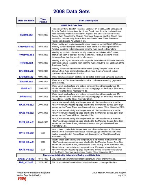
Data Set NameTimePeriod<strong>2008</strong> Data SetsHBMP SAS Data SetsBrief DescriptionFlwd08.sd2 1931-<strong>2008</strong>Historic daily flow data for: Peace at Bartow, Fort Meade, Zolfo Springs andArcadia. Daily tributary flows for: Horse Creek near Arcadia; Joshua Creeknear Nocatee; Prairie Creek near Ft. Ogden; and Shell Creek near PuntaGorda. Daily flows for the Myakka River near Sarasota and Big Slough nearNorth Port. Historic daily Peace River and Shell Creek Water TreatmentFacility withdrawals. All values in cfs.Cmov8308.sd2 1983-<strong>2008</strong>Water quality and phytoplankton biomass measurements (1983-<strong>2008</strong>) frommonthly surface samples collected at each of the four moving isohalines.Relative locations reflect distances from the river mouth in kilometers.Hymov08.sd2 1983-<strong>2008</strong>Monthly hydrolab in situ water quality measurements taken at 0.5 meterintervals at each of the four moving isohalines. Relative locations reflectdistances from the river mouth in kilometers.Hyfix08.sd2 1996-<strong>2008</strong>Monthly in situ hydrolab water column profile data taken at 0.5 meter intervalsfrom fixed sample locations from near the river’s mouth to just upstream of theTreatment Facility.Cfix9608.sd2 1996-<strong>2008</strong>Monthly surface and bottom chemical water quality samples taken at fiveintervals from fixed sample locations from near the river’s mouth to justupstream of the Treatment Facility.Efix9608.sd2 1996-<strong>2008</strong> Water column extinction coefficients collected at the fixed sampling locations.Boca04.sd2 1996-2004Water level at 15-minute intervals from the continuous recording gage nearBoca Grande.HH08.sd2 1996-<strong>2008</strong>Water Level, and surface and bottom conductivity and temperature at 15-minute intervals from the continuous recording gage on the Peace River nearHarbor Heights (River Kilometer 15.5).PRH08.sd2 1997-<strong>2008</strong>Water Level, and surface and bottom conductivity and temperature at 15-minute intervals from the continuous recording gage on the Peace River nearPeace River Heights (River Kilometer 26.7).RK21_08.sd2 2006-<strong>2008</strong>Near surface conductivity and temperature at 15-minute intervals from theHBMP continuous recording gage attached to the Manatee Speed Zone Signlocated on the Peace River near Liverpool side channel (River Kilometer 21.9).RK23_08.sd2 2006-<strong>2008</strong>Near surface conductivity and temperature at 15-minute intervals from theHBMP continuous recording gage attached to the Manatee Speed Zone Signlocated on the Peace at River Kilometer 23.4.RK24_08.sd2 2006-<strong>2008</strong>Near surface conductivity and temperature at 15-minute intervals from theHBMP continuous recording gage attached to the Manatee Speed Zone Signlocated on the Peace River just downstream of Navigator Marina (RiverKilometer 24.5).RK12_08.sd2 <strong>2008</strong>Near bottom conductivity, temperature and dissolved oxygen at 15-minuteintervals from the HBMP continuous recording gage attached to a channelmarker located on the Peace River just downstream of Shell Creek (RiverKilometer 12.9).RK30_08.sd2 <strong>2008</strong>Near surface conductivity and temperature at 15-minute intervals from theHBMP continuous recording gage attached to the Manatee Speed Zone Signlocated on the Peace River just upstream of the Facility (River Kilometer 30.6).RK31_08.sd2 <strong>2008</strong>Near surface conductivity and temperature at 15-minute intervals from theHBMP continuous recording gage attached to the old railroad trestle locatedon the Peace River just upstream of Facility (River Kilometer 31.7).Environmental Quality Laboratory Background Data SetsChem_v12.sd2 1976-1990 EQL fixed station Charlotte Harbor background water chemistry data.Hall_v12.sd2 1976-1990 EQL fixed station Charlotte Harbor hydrolab water column profile data.Peace River Manasota Regional<strong>2008</strong> HBMP Annual Data ReportWater Supply Authority May 2009