catagory?transportation / directionsDistances / to Popular New England PortsLeaving from NewportBlock Island, RI .............................................. 20 nmFisher’s Island/Mystic, CT .......................... 34 nmStratford .......................................................... 84 nmOld Saybrook .................................................. 50 nmStamford, CT ...................................................108 nmManhattan, NY ..............................................140 nmMontauk,NY .................................................... 38 nmSag Harbor, (Long Island) NY ................... 55 nmPort Jefferson, NY ........................................ 90 nmPort Washington, (Long Island) NY .......124 nmCuttyhunk, MA ............................................... 22 nmPadnaram, MA .............................................. 25 nmMarion, MA ..................................................... 39 nmCape Cod Canal-North End, MA ............. 52 nmWoods Hole, MA .......................................... 35 nmVineyard Haven, Martha’s V.,MA ........... 40 nmEdgartown, Martha’s V.,MA ..................... 48 nmNantucket, MA .............................................. 66 nmHyannis, MA ................................................... 56 nmFalmouth, MA ................................................. 40 nmPlymouth, MA ................................................ 69 nmProvincetown, MA, ..................................... 75 nmBoston, MA .....................................................104 nmMarblehead, MA ..........................................104 nmSalem, MA .......................................................108 nmManchester ....................................................105 nmGloucester Portland, ME ...........................105 nmPortsmouth ...................................................... 85 nmPortland, ME ...................................................175 nmFalmouth ...........................................................175 nmBooth Bay ........................................................202 nmRockland ..........................................................216 nmCamden, ME ...................................................223 nmNortheast .........................................................275 nmSouth West Harbor, ME .............................275 nmSample: Newport and South of the Cape(Allowing for one lay day along the way or a late afternoon boarding)1. Newport to Block Island ........................20 nm2. Block Island to Edgartown ...................60 nm3. Edgartown to Nantucket .......................25 nm4. Nantucket to Woods’ Hole ...................32 nm5. Woods’ Hole to Cuttyhunk ....................22 nm6. Cuttyhunk to Newport ............................22 nmTOTAL ................................................................181 nmTransportationTaxi ServiceCozy Cab: (401) 846-2500Car RentalsHertz: (401) 846-1645 Thrifty: \(401) 846-3200Amtrak Train ServiceAmtrak Stations: Kingstown, RI 800-872-7245 Providence, RI 800-872-7245Airport InformationTF Green Airport: Warwick, RI (401) 737-4000Logan Airport: Boston, MA (617) 973-5500Newport Airport: Middletown, RI (401) 846-2200Bus Route InformationRI Transportation Authority: Service in Newport (401) 847-0209Bonanza Bus Station: Service outside Newport (401) 846-1820Ferry ServiceBlock Island to New London, CT: Summer only (401) 783-4613Point Judith, RI to Block Island: All year round (401) 783-4613Newport to Block Island: Summer only (401) 422-7891Block Island to Point Judith: All year round (401) 783-4613Block Island to Montauk Point, NY: May - Nov (516) 253-9808Bristol, RI, to Prudence & Hog Islands: (401) 253-9808Directions to <strong>NYM</strong> /Portsmouth, RIBefore You Set Sail...Come Aboard with Us!Executive Jet Charter,Aircraft Sales and ManagementWest Coast Sales: (760) 327-2780East Coast Sales (845) 825-4540www.worldwidejet.comFrom points North, Boston or Logan Airport (est. 1hr. 30 minutes)— Rte 93 south. After tunnel follow signs for Interstate 93 South (est.10 miles)— Pick up Rt 128 North (est. 2 miles) then pick up Rt 24 to Fall River (est. 50 miles)— In Fall River pick up Rt 195 West (est. 1 mile) then take 1st Exit to Rt. 114 Westto Newport— Follow Rt. 114 to a light by Dunkin Donuts, turn right and go down hill,follow signs to New England Boatworks.— <strong>NYM</strong> is above the Ships Store.To get to Newport follow signs to downtown NewportFrom TF Green Airport (est. 45 minutes) From points South— Pick up Rt 95 South to NY — Proceed on Rt 95 North— Pick up Rt 4 South — Take Exit #3 Rt 138 East— Pick up Rt 138 East pass University of Rhode IslandFrom the time you take Exit 3 and reach the bridges it will take an est. 30 minutes— Go over the Jamestown Bridge— Go over the Newport Bridge (toll)— Take the 1st exit off bridge (Scenic Exit)— Turn right at 2nd light, then turn right at the next lightand look for the shipyard at the stop sign to your left16<strong>2006</strong> NEWPORT YACHT MANAGEMENT SHOW Official <strong>Show</strong> <strong>Directory</strong> Presented by International Yacht Vacations&Charters www.YachtChartersMagazine.com
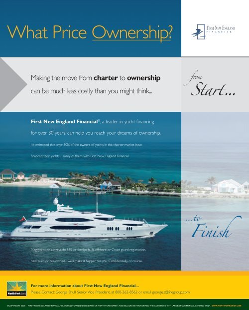
catagory? fromStart... ...toFinish©COPYRIGHT <strong>2006</strong>FIRST NEW ENGLAND FINANCIAL © IS A WHOLLY-OWNED SUBSIDIARY OF NORTH FORK BANK © , A $60 BILLION INSTITUTION AND THE COUNTRY’S 16TH LARGEST COMMERCIAL LENDING BANK. WWW.NORTHFORKBANK.COM