NASA Goddard Space Flight Center Ocean Data Processing System ...
NASA Goddard Space Flight Center Ocean Data Processing System ...
NASA Goddard Space Flight Center Ocean Data Processing System ...

Create successful ePaper yourself
Turn your PDF publications into a flip-book with our unique Google optimized e-Paper software.
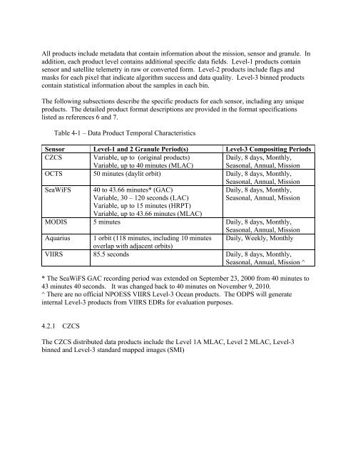
All products include metadata that contain information about the mission, sensor and granule. Inaddition, each product level contains additional specific data fields. Level-1 products containsensor and satellite telemetry in raw or converted form. Level-2 products include flags andmasks for each pixel that indicate algorithm success and data quality. Level-3 binned productscontain statistical information about the samples in each bin.The following subsections describe the specific products for each sensor, including any uniqueproducts. The detailed product format descriptions are provided in the format specificationslisted as references 6 and 7.Table 4-1 – <strong>Data</strong> Product Temporal CharacteristicsSensor Level-1 and 2 Granule Period(s) Level-3 Compositing PeriodsCZCS Variable, up to (original products)Variable, up to 40 minutes (MLAC)Daily, 8 days, Monthly,Seasonal, Annual, MissionOCTS 50 minutes (daylit orbit) Daily, 8 days, Monthly,Seasonal, Annual, MissionSeaWiFS 40 to 43.66 minutes* (GAC)Variable, 30 – 120 seconds (LAC)Daily, 8 days, Monthly,Seasonal, Annual, MissionVariable, up to 15 minutes (HRPT)Variable, up to 43.66 minutes (MLAC)MODIS 5 minutes Daily, 8 days, Monthly,Seasonal, Annual, MissionAquarius 1 orbit (118 minutes, including 10 minutes Daily, Weekly, Monthlyoverlap with adjacent orbits)VIIRS 85.5 seconds Daily, 8 days, Monthly,Seasonal, Annual, Mission ^* The SeaWiFS GAC recording period was extended on September 23, 2000 from 40 minutes to43 minutes 40 seconds. It was changed back to 40 minutes on November 9, 2010.^ There are no official NPOESS VIIRS Level-3 <strong>Ocean</strong> products. The ODPS will generateinternal Level-3 products from VIIRS EDRs for evaluation purposes.4.2.1 CZCSThe CZCS distributed data products include the Level 1A MLAC, Level 2 MLAC, Level-3binned and Level-3 standard mapped images (SMI)


![Franz ocrt_terra_franz.ppt [Read-Only] - Ocean Color - NASA](https://img.yumpu.com/24076593/1/190x146/franz-ocrt-terra-franzppt-read-only-ocean-color-nasa.jpg?quality=85)