Existing Conditions Existing Conditions Final - City & County of ...
Existing Conditions Existing Conditions Final - City & County of ...
Existing Conditions Existing Conditions Final - City & County of ...

You also want an ePaper? Increase the reach of your titles
YUMPU automatically turns print PDFs into web optimized ePapers that Google loves.
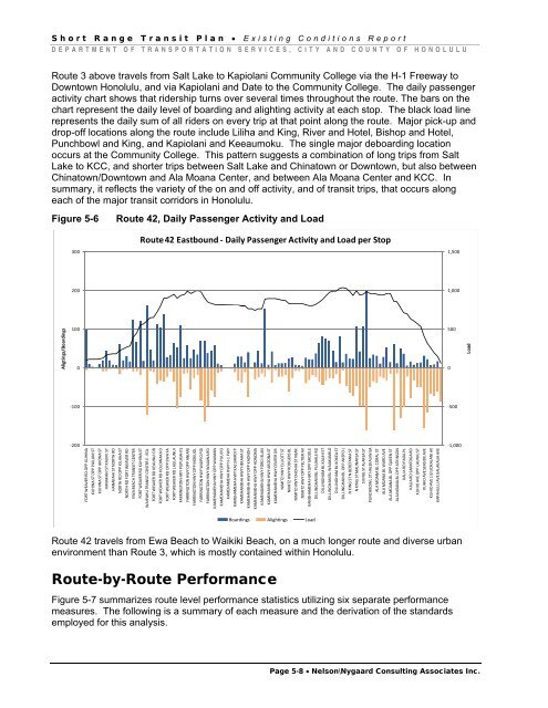
Short Range Transit Plan • <strong>Existing</strong> <strong>Conditions</strong> ReportDEPARTMENT OF TRANSPORTATION SERVICES, CITY AND COUNTY OF HONOLULURoute 3 above travels from Salt Lake to Kapiolani Community College via the H-1 Freeway toDowntown Honolulu, and via Kapiolani and Date to the Community College. The daily passengeractivity chart shows that ridership turns over several times throughout the route. The bars on thechart represent the daily level <strong>of</strong> boarding and alighting activity at each stop. The black load linerepresents the daily sum <strong>of</strong> all riders on every trip at that point along the route. Major pick-up anddrop-<strong>of</strong>f locations along the route include Liliha and King, River and Hotel, Bishop and Hotel,Punchbowl and King, and Kapiolani and Keeaumoku. The single major deboarding locationoccurs at the Community College. This pattern suggests a combination <strong>of</strong> long trips from SaltLake to KCC, and shorter trips between Salt Lake and Chinatown or Downtown, but also betweenChinatown/Downtown and Ala Moana Center, and between Ala Moana Center and KCC. Insummary, it reflects the variety <strong>of</strong> the on and <strong>of</strong>f activity, and <strong>of</strong> transit trips, that occurs alongeach <strong>of</strong> the major transit corridors in Honolulu.Figure 5-6Route 42, Daily Passenger Activity and LoadRoute 42 Eastbound ‐ Daily Passenger Activity and Load per Stop3001,5002001,000Aligtings/Boardings10005000Load‐100‐500‐200FORT WEAVER RD OPP KUHINAKUHINA ST OPP PAILANI STKUHINA ST OPP AHONA STHANAKAHI ST KAUIKI STHANAKAHI ST NORTH RDNORTH RD OPP KILAHA STNORTH RD FORT WEAVER RDEWA BEACH TRANSIT CENTERFORT WEAVER RD KUHINA STWAIPAHU TRANSIT CENTER E ‐ EOLFORT WEAVER RD KEAUNUI DRFORT WEAVER RD KOLOWAKA DFORT WEAVER RD OPP EWA FAFORT WEAVER RD LAULAUNUIFARRINGTON HWY PUPUKAHI SFARRINGTON HWY OPP ANIANIFARRINGTON HWY OPP MOKUOLFARRINGTON HWY WAIPIO POIFARRINGTON HWY WAIAWA RDKAMEHAMEHA HWY OPP WAIMANKAMEHAMEHA HWY OPP PUU POKAMEHAMEHA HWY H‐1 FWYKAMEHAMEHA HWY KALUAMOI PKAMEHAMEHA HWY HEKAHA STKAMEHAMEHA HWY OPP KAONOHKAMEHAMEHA HWY OPP HONOMAKAMEHAMEHA HWY FORD ISLANKAMEHAMEHA HWY ARIZONA STKAMEHAMEHA HWY CENTER DRNIMITZ HWY ELLIOTT STNIMITZ HWY RODGERS BLNIMITZ HWY OHOHIA ST NEARNIMITZ HWY OPP PELTIER AVKAMEHAMEHA HWY OPP MIDDLEDILLINGHAM BL PUUHALE RDDILLINGHAM BL KALIHI STDILLINGHAM BL WAIAKAMILODILLINGHAM BL KOKEA STDILLINGHAM BL OPP AKEPO LN KING ST N BERETANIA STN KING ST MAUNAKEA STS KING ST ALAKEA STPUNCHBOWL ST HALEKAUWILAALA MOANA BL CORAL STALA MOANA BL WARD AVEALA MOANA BL OPP QUEEN STALA MOANA BL OPP ATKINSONKALIA RD PAOA PLKALIA RD SARATOGA RDKUHIO AVE OPP LAUNIU STKUHIO AVE SEASIDE AVEKUHIO AVE LILIUOKALANI AVKAPAHULU AVE KALAKAUA AVE‐1,000Boardings Alightings LoadRoute 42 travels from Ewa Beach to Waikiki Beach, on a much longer route and diverse urbanenvironment than Route 3, which is mostly contained within Honolulu.Route-by-Route PerformanceFigure 5-7 summarizes route level performance statistics utilizing six separate performancemeasures. The following is a summary <strong>of</strong> each measure and the derivation <strong>of</strong> the standardsemployed for this analysis.Page 5-8 • Nelson\Nygaard Consulting Associates Inc.