NATIONAL PROFILE 2011-2012 - ICYE
NATIONAL PROFILE 2011-2012 - ICYE
NATIONAL PROFILE 2011-2012 - ICYE
- No tags were found...

You also want an ePaper? Increase the reach of your titles
YUMPU automatically turns print PDFs into web optimized ePapers that Google loves.
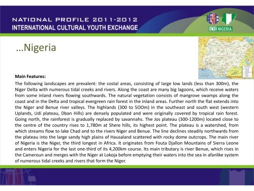
…NigeriaMain Features:The following landscapes are prevalent: the costal areas, consisting of large low lands (less than 300m), theNiger Delta with numerous tidal creeks and rivers. Along the coast are many big lagoons, which receive watersfrom some inland rivers flowing southwards. The natural vegetation consists of mangrove swamps along thecoast and in the Delta and tropical evergreen rain forest in the inland areas. Further north the flat extends intothe Niger and Benue river valleys. The highlands (300 to 5OOm) in the southeast and south west (westernUplands, Udi plateau, Dban Hills) are densely populated and were originally covered by tropical rain forest.Going north, the rainforest is gradually replaced by savannahs. The Jos plateau (300-1200m) located close tothe centre of the country rises to 1,780m at Shere hills, its highest point. The plateau is a watershed, fromwhich streams flow to lake Chad and to the rivers Niger and Benue. The line declines steadily northwards fromthe plateau into the large sandy high plains of Hausaland scattered with rocky dome outcrops. The main riverof Nigeria is the Niger, the third longest in Africa. It originates from Fouta Djallon Mountains of Sierra Leoneand enters Nigeria for the last one-third of its 4,200km course. Its main tributary is river Benue, which rises inthe Cameroun and merges with the Niger at Lokoja before emptying their waters into the sea in afanlike systemof numerous tidal creeks and rivers that form the Niger.