ALUMNI NEWSLETTER - Earth Sciences - University of Minnesota
ALUMNI NEWSLETTER - Earth Sciences - University of Minnesota
ALUMNI NEWSLETTER - Earth Sciences - University of Minnesota

Create successful ePaper yourself
Turn your PDF publications into a flip-book with our unique Google optimized e-Paper software.
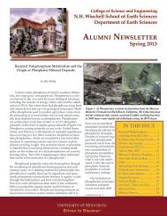
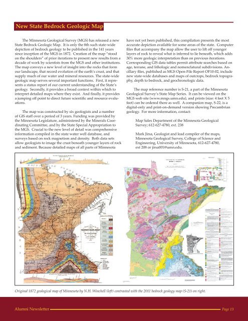
New State Bedrock Geologic MapThe <strong>Minnesota</strong> Geological Survey (MGS) has released a newState Bedrock Geologic Map. It is only the 8th such state-widedepiction <strong>of</strong> bedrock geology to be published in the 141 yearssince inception <strong>of</strong> the MGS in 1872. Creation <strong>of</strong> the map “stoodon the shoulders” <strong>of</strong> prior iterations to present new results from adecade <strong>of</strong> work by scientists from the MGS and other institutions.The map conveys a new level <strong>of</strong> insight into the rocks that formour landscape, that record evolution <strong>of</strong> the earth’s crust, and thatsupply much <strong>of</strong> our water and mineral resources. The state-widegeologic map serves several important functions. First, it representsa status report <strong>of</strong> our current understanding <strong>of</strong> the State’sgeology. Secondly, it provides a broad context within which tointerpret detailed maps where they exist. And finally, it providesa jumping <strong>of</strong>f point to direct future scientific and resource evaluations.The map was constructed by six geologists and a number<strong>of</strong> GIS staff over a period <strong>of</strong> 3 years. Funding was provided bythe <strong>Minnesota</strong> Legislature, administered by the Minerals CoordinatingCommittee, and by the State Special Appropriation tothe MGS. Crucial to the new level <strong>of</strong> detail was comprehensiveinformation compiled in the state water well database, andsurveys based on rock magnetism and density. Both data setsallow geologists to image the crust beneath younger layers <strong>of</strong> rockand sediment. Because detailed maps <strong>of</strong> all parts <strong>of</strong> <strong>Minnesota</strong>have not yet been published, this compilation presents the mostaccurate depiction available for some areas <strong>of</strong> the state. Computerfiles that accompany the map allow the user to lift <strong>of</strong>f youngerlayers <strong>of</strong> rock to reveal what is inferred to lie beneath, which adds30% more geologic interpretation than on previous iterations.Corresponding GIS data tables permit attribute searches based onage, terrane, and lithologic and nomenclatural subdivisions. Ancillaryfiles, published as MGS Open-File Report OF10-02, includenew state-wide databases and maps <strong>of</strong> outcrops, bedrock topography,depth to bedrock, and geochronologic data.The map reference number is S-21, a part <strong>of</strong> the <strong>Minnesota</strong>Geological Survey’s State Map Series. It can be viewed on theMGS web site (www.mngs.umn.edu), and prints (size: 4 feet X 5feet) can be ordered there as well. A companion map, S-22, is adigital-only and print-on-demand version showing Precambriangeology. For more information, contact:Map Sales Department <strong>of</strong> the <strong>Minnesota</strong> GeologicalSurvey; 612-627-4780, ext. 238Mark Jirsa, Geologist and lead compiler <strong>of</strong> the maps,<strong>Minnesota</strong> Geological Survey, College <strong>of</strong> Science andEngineering, <strong>University</strong> <strong>of</strong> <strong>Minnesota</strong>, 612-627-4780,ext 208 or jirsa001@umn.edu.Original 1872 geological map <strong>of</strong> <strong>Minnesota</strong> by N.H. Winchell (left) contrasted with the 2011 bedrock geology map (S-21) on right.Alumni NewsletterPage 13