Nemo-Link-UK-Marine-Environmental-Statement
Nemo-Link-UK-Marine-Environmental-Statement
Nemo-Link-UK-Marine-Environmental-Statement
Create successful ePaper yourself
Turn your PDF publications into a flip-book with our unique Google optimized e-Paper software.
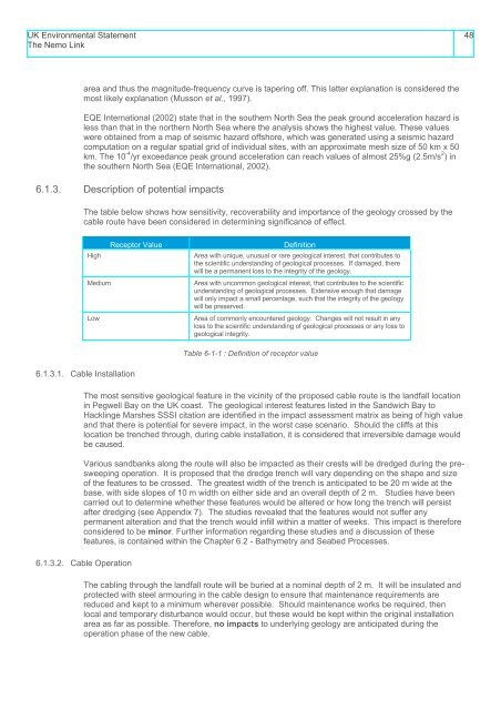
<strong>UK</strong> <strong>Environmental</strong> <strong>Statement</strong>The <strong>Nemo</strong> <strong>Link</strong>48area and thus the magnitude-frequency curve is tapering off. This latter explanation is considered themost likely explanation (Musson et al., 1997).EQE International (2002) state that in the southern North Sea the peak ground acceleration hazard isless than that in the northern North Sea where the analysis shows the highest value. These valueswere obtained from a map of seismic hazard offshore, which was generated using a seismic hazardcomputation on a regular spatial grid of individual sites, with an approximate mesh size of 50 km x 50km. The 10 -4 /yr exceedance peak ground acceleration can reach values of almost 25%g (2.5m/s 2 ) inthe southern North Sea (EQE International, 2002).6.1.3. Description of potential impactsThe table below shows how sensitivity, recoverability and importance of the geology crossed by thecable route have been considered in determining significance of effect.Receptor ValueHighMediumLowDefinitionArea with unique, unusual or rare geological interest, that contributes tothe scientific understanding of geological processes. If damaged, therewill be a permanent loss to the integrity of the geology.Area with uncommon geological interest, that contributes to the scientificunderstanding of geological processes. Extensive enough that damagewill only impact a small percentage, such that the integrity of the geologywill be preserved.Area of commonly encountered geology. Changes will not result in anyloss to the scientific understanding of geological processes or any loss togeological integrity.Table 6-1-1 : Definition of receptor value6.1.3.1. Cable InstallationThe most sensitive geological feature in the vicinity of the proposed cable route is the landfall locationin Pegwell Bay on the <strong>UK</strong> coast. The geological interest features listed in the Sandwich Bay toHacklinge Marshes SSSI citation are identified in the impact assessment matrix as being of high valueand that there is potential for severe impact, in the worst case scenario. Should the cliffs at thislocation be trenched through, during cable installation, it is considered that irreversible damage wouldbe caused.Various sandbanks along the route will also be impacted as their crests will be dredged during the presweepingoperation. It is proposed that the dredge trench will vary depending on the shape and sizeof the features to be crossed. The greatest width of the trench is anticipated to be 20 m wide at thebase, with side slopes of 10 m width on either side and an overall depth of 2 m. Studies have beencarried out to determine whether these features would be altered or how long the trench will persistafter dredging (see Appendix 7). The studies revealed that the features would not suffer anypermanent alteration and that the trench would infill within a matter of weeks. This impact is thereforeconsidered to be minor. Further information regarding these studies and a discussion of thesefeatures, is contained within the Chapter 6.2 - Bathymetry and Seabed Processes.6.1.3.2. Cable OperationThe cabling through the landfall route will be buried at a nominal depth of 2 m. It will be insulated andprotected with steel armouring in the cable design to ensure that maintenance requirements arereduced and kept to a minimum wherever possible. Should maintenance works be required, thenlocal and temporary disturbance would occur, but these would be kept within the original installationarea as far as possible. Therefore, no impacts to underlying geology are anticipated during theoperation phase of the new cable.


