What is Geophysics? - Cambridge Archaeology Field Group
What is Geophysics? - Cambridge Archaeology Field Group
What is Geophysics? - Cambridge Archaeology Field Group

You also want an ePaper? Increase the reach of your titles
YUMPU automatically turns print PDFs into web optimized ePapers that Google loves.
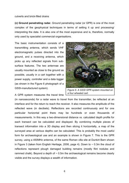
culverts and brick-filled drains(c) Ground penetrating radar. Ground penetrating radar (or GPR) <strong>is</strong> one of the mostcomplex of the geophysical techniques in terms of setting it up and processing/interpreting the data. It <strong>is</strong> also one of the most expensive and <strong>is</strong>, therefore, normallyonly used by special<strong>is</strong>t commercial organ<strong>is</strong>ations.The basic instrumentation cons<strong>is</strong>ts of atransmitting antenna, which sends VHFelectromagnetic pulses directed into theground, and a receiving antenna, whichpicks up any reflected signals from subsurfacefeatures. The two antennae areusually mounted as close to the ground aspossible, usually in a cart together with apower supply, controller and a data logger(as shown in the Figure 6 photograph of aGSSI-manufactured system).A GPR system measures the travel time(in nanoseconds) for a radar wave to travel from the transmitter, be reflected at aninterface and for the return to reach the receiver. It also measures the amplitude of thereflected wave (in decibels). Reflections are recorded continuously and for oneparticular horizontal point there may be hundreds or even thousands ofmeasurements. In th<strong>is</strong> way a two-dimensional d<strong>is</strong>tance vs. calculated depth profile foreach transect can be calculated and d<strong>is</strong>played. By combining multiple pieces oftransect information into a 3D d<strong>is</strong>play and then slicing it horizontally, a map of thesurveyed area at various depths can be calculated. Th<strong>is</strong> <strong>is</strong> probably the most usefulform for archaeological use and an example <strong>is</strong> shown in Figure 7. Th<strong>is</strong> <strong>is</strong> the GPRsurvey, using a 450MHz antenna, of the same Roman villa site at Dunkirt Barn shownin Figure 3 (taken from Engl<strong>is</strong>h Heritage, 2006, page 4). Down to ~ 0.3m the cloud ofreflections represent plough damaged building remains (mostly flint nodules andrammed chalk). Beyond a depth of ~ 0.5m the archaeological remains become clearlyv<strong>is</strong>ible and the survey d<strong>is</strong>plays a wealth of information.Figure 6. A GSSI GPR system mounted ona four wheeled cart.6