
You also want an ePaper? Increase the reach of your titles
YUMPU automatically turns print PDFs into web optimized ePapers that Google loves.
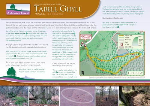
HISTORY & ARCHAEOLOGY SERIESTABELL GHYLLWALK 122.5 miles/4kmmade to improve some of the <strong>Forest</strong> lands for agriculture.The large trees along the bank, one an old coppiced beechtree, were possibly once part of a hedge. The fence to the rightmarks the boundary of the army training area at Pippingford.Continue downhill on the path.Park in Lintons car park, cross the road and walk through Ridge car park. Take the right hand track out of theback of the car park, cross a broad track (once the old road from Wych Cross to Coleman’s Hatch) and take thepath descending into the wood on the other side. Cross over a small stream and keep on the main path ahead.By a gate, on the corner of the boundary bank, is agood specimen of a managed beech acting as aboundary marker tree 5 .Just off the path to the right, opposite a couple of yew trees,is one of the pillow mounds 1 , which looks like a ditch andbank. These mounds were used for farming rabbits. The pathcuts through the pillow mound and another yew tree onthe left marks one end.Turn right uphill by the yew tree at the end of the pillow mound,then left along a track through coppiced chestnut woodland.After 50m, just off the path on the left, is one of three curvedpillow mounds in this area, a moss-covered bank with a ditchin front of it 2 . Coppiced chestnut trees have been plantedafter the pillow mounds went out of use.Return to the path. Where the pillow mound turns a corneron the left go straight ahead on the right-hand path.After about 200m, on the left just afterthe path begins to drop, is a mysteriousrectangular hole about 3m by 2mwith banks of soil to either side 3 .This could be a saw-pit, but as themilitary used this area in the past fortraining it might be a military feature.Immediately after this, just offthe path to the left, are severalmoss-covered ridges which arethe remnants of three disusedrouteways, or hollow ways throughthe wood. Just after a yew tree, onthe right of the track, is anotherpossible saw pit, much eroded.Continue along path and carry ondownhill to a more open area.The very regular-looking bank to theright 4 formed part of one of thelate 17th to early 18th centuryenclosure fields, when attempts wereContains Ordnance Survey data © Crown copyright and database right 2012 and data © OpenStreetMap contributors CC-BY-SACoppiced chestnut on a pillow mound A coppiced Beech at <strong>Tabell</strong> <strong>Ghyll</strong> A LiDAR image of 3 horse-shoe shaped pillow moundsHollow way Boundary bank starting at point 6