Prior Lake - Spring Lake Watershed District 2009 Water Quality ...
Prior Lake - Spring Lake Watershed District 2009 Water Quality ...
Prior Lake - Spring Lake Watershed District 2009 Water Quality ...

Create successful ePaper yourself
Turn your PDF publications into a flip-book with our unique Google optimized e-Paper software.
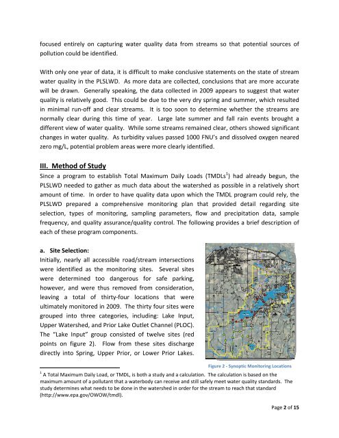
focused entirely on capturing water quality data from streams so that potential sources ofpollution could be identified.With only one year of data, it is difficult to make conclusive statements on the state of streamwater quality in the PLSLWD. As more data are collected, conclusions that are more accuratewill be drawn. Generally speaking, the data collected in <strong>2009</strong> appears to suggest that waterquality is relatively good. This could be due to the very dry spring and summer, which resultedin minimal run‐off and clear streams. It is too soon to determine whether the streams arenormally clear during this time of year. Large late summer and fall rain events brought adifferent view of water quality. While some streams remained clear, others showed significantchanges in water quality. As turbidity values passed 1000 FNU’s and dissolved oxygen nearedzero mg/L, potential problem areas were more clearly identified.III. Method of StudySince a program to establish Total Maximum Daily Loads (TMDLs 1 ) had already begun, thePLSLWD needed to gather as much data about the watershed as possible in a relatively shortamount of time. In order to have quality data upon which the TMDL program could rely, thePLSLWD prepared a comprehensive monitoring plan that provided detail regarding siteselection, types of monitoring, sampling parameters, flow and precipitation data, samplefrequency, and quality assurance/quality control. The following provides a brief description ofeach of these program components.a. Site Selection:Initially, nearly all accessible road/stream intersectionswere identified as the monitoring sites. Several siteswere determined too dangerous for safe parking,however, and were thus removed from consideration,leaving a total of thirty‐four locations that wereultimately monitored in <strong>2009</strong>. The thirty four sites weregrouped into three categories, including: <strong>Lake</strong> Input,Upper <strong><strong>Water</strong>shed</strong>, and <strong>Prior</strong> <strong>Lake</strong> Outlet Channel (PLOC).The “<strong>Lake</strong> Input” group consisted of twelve sites (redpoints on figure 2). Flow from these sites dischargedirectly into <strong>Spring</strong>, Upper <strong>Prior</strong>, or Lower <strong>Prior</strong> <strong>Lake</strong>s.Figure 2 ‐ Synoptic Monitoring Locations1 A Total Maximum Daily Load, or TMDL, is both a study and a calculation. The calculation is based on themaximum amount of a pollutant that a waterbody can receive and still safely meet water quality standards. Thestudy determines what needs to be done in the watershed in order for the stream to reach that standard(http://www.epa.gov/OWOW/tmdl).Page 2 of 15