High-Resolution Acoustic Multibeam Surveys for Bridge Assessment
High-Resolution Acoustic Multibeam Surveys for Bridge Assessment
High-Resolution Acoustic Multibeam Surveys for Bridge Assessment

Create successful ePaper yourself
Turn your PDF publications into a flip-book with our unique Google optimized e-Paper software.
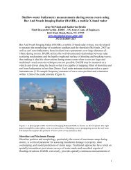
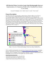
comparative multibeam survey and scour data that could be used <strong>for</strong> computing a depth differencesurface between the two surveys and evaluating the erosional and depositional patterns around thebridge.Prior to the start of each multibeam survey operation, Substructure established a real‐time kinematic(RTK) differential Global Positioning System (DGPS) base station over a known survey control pointprovided by ME DOT to ensure high resolution vertical and horizontal accuracies (cm‐level) throughoutthe survey operations (Figure 3). This level of accuracy was critical to ensure proper positioning andimaging of the structural supports <strong>for</strong> each of the bridges and also the consistency of the data betweendifferent survey periods. Substructure’s custom built survey vessel Orion was used to acquire extensivemultibeam data around each of the bridges (Figure 3). Standard survey equipment on Orion includes anR2Sonic 2024 multibeam echosounder, Applanix 320 POSMV vessel motion reference and navigationunit, Odom Digibar speed of sound profiler, and HYPACK/HYSWEEP hydrographic data acquisition andprocessing software. For these surveys, the multibeam transducer was rotated outward 20° somultibeam data could be acquired almost up to the water surface on the port side, maximizing datacoverage around the structural supports.Final data deliverables <strong>for</strong> both baseline and current‐conditions surveys include gridded products thatwere created by averaging or selecting just the shallowest sounding within a half‐foot square grid acrossthe entire survey area. The tightly gridded dataset provides a high‐resolution view of the entire surveyarea around the bridge, while helping to reduce the overall size of the dataset. The gridded datasetsare used to create various hillshade surface models around the bridge that can be manipulated in avariety of ways to help with the visualization of the overall bathymetry around the bridge (Figures 4 &5). These gridded datasets are also used to compute the depth difference surfaces between surveysthat are used to evaluate local seafloor change. Within a smaller area around each of the structuralsupports, numerous full‐resolution point cloud datasets were created that included all of the validmultibeam soundings within that area. These dense datasets were manipulated within a cloud dataviewer to produce numerous static images of each of the supports. Several of these images wereeventually included within the final bridge inspection report (Figure 6 & 7).In addition, a comparative depth difference grid surface was also created between the initial baselinesurvey and the subsequent current condition survey around the Richmond <strong>Bridge</strong> (Figure 8). This depthdifference grid quantitatively depicted the relative change across the entire area between the times ofthe two surveys. Even subtle areas of change, such as migrating sand waves, could clearly be seen in thedepth difference results. In addition, larger areas of more uni<strong>for</strong>m change could also be detected andexamined. This enabled a more complete assessment of the erosional and depositional patterns acrossthe entire bridge area. This in turn, allowed a more comprehensive evaluation of the scour potentialaround the structure, both in the near term and in the future.CONCLUSIONThe US Army Corps of Engineers (USACE) New England District has recently begun to require pre‐ andpost‐construction multibeam surveys <strong>for</strong> all new bridge construction that may have the potential toimpact a federal navigation channel. This is a permitting and regulatory requirement that is primarilyfocused on ensuring that the bridge construction project does not create any obstructions or otherhazards to navigation within the navigation channel. Though the intent of these pre‐ and postconstructionmultibeam surveys is focused primarily on evaluating impacts to navigation, they also havethe potential to provide high‐resolution baseline survey data around the new bridges that should prove6