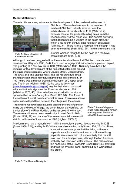
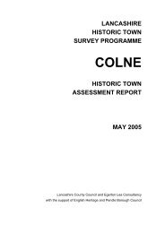
<strong>Lancashire</strong> Historic Town SurveySlaidburnMedieval SlaidburnThere is little surviving evidence for the development of the medieval settlement ofSlaidburn. The earliest element in the creation ofmedieval Slaidburn is likely to have been theestablishment of the church, in 1119 (Mills nd, 2),however most of the present building dates from thefifteenth century (Peel 1922, 25). The earliest survivingfabric appears to be a window in the south aisle, forwhich a fourteenth century date has been postulated(Mills nd., 6). There is also a Norman font although it hasbeen re-modelled (Peel 1922, 25). In the churchyard is aPlate 1: West elevation ofSlaidburn Churchsundial, which is though to be the base of a medievalcross (Higham 1985, 3, 4).Although it has been suggested that the medieval settlement at Slaidburn is a planneddevelopment (Higham 1985, 3- 4), there is no topographical evidence for a planned layout.The granting of a four day fair in 1294 (McCutcheon 1940, 165) may have been theimpetus for the development of the nucleated settlement aroundthe staggered crossroads, where Church Street, Chapel Street,The Shay and The Skaithe meet, and the resulting two small,triangular open areas may have marked the site of the fair. In1591 there was a market cross at the junction of Chapel Streetand The Shay (Higham 1985, 4), the base to this cross(www.imagesofengland.org.uk) may be that which has stoodadjacent to the bridge over the River Hodder since 1878(Whitaker 1878, 43). It reportedly once stood with the stocksopposite the Hark-to-Bounty Inn (Peel 1922, 39). The focus ofthe settlement is still clearly around this area. There was alwaysopen, undeveloped land between the village and the church.There were two townfields situated close to the church; one onrising ground west of village; the other, known as Highfield, onthe far side of the River Hodder, on higher ground to the east.There were still some unenclosed strips in west field in 1844(Porter 1994, 39) and traces of the former town fields were stillvisible north-west of the church in 1985 (Higham 1985, 3).Plate 2: Area of staggeredcross roads (possible formermarket place), Slaidburn;with C20th war memorialSlaidburn also had a manorial corn mill in the medieval period. It was working in 1258(Shaw 1956, 224), and by 1422-3 there was also a fulling mill (Shaw 1956, 251-2). Thereis no evidence to suppose that the fulling mill was aseparate establishment from the corn mill, even thoughseparate rents were paid. It is more likely that the millwas used for a dual purpose, although the two functionsprobably had their own water wheels. The mill stood onthe north side of the Croasdale Brook (OS 1850 1:10560),and was fed by a mill pond, controlled by a weir acrossthe brook.Plate 3: The Hark to Bounty Inn© <strong>Lancashire</strong> <strong>County</strong> <strong>Council</strong> 2006 12
<strong>Lancashire</strong> Historic Town SurveySlaidburn4.5 Post-medievalWith enclosure of some of the commons in 1608 (Porter 1980, 30), the population ofSlaidburn increased (Porter 1976, 4), leading to the construction of new houses, as well asturf houses, lime kilns and barns. The building plots appear to have been quite small,mainly below a customary acre (Porter 1976, 9). Although some of these buildings wouldhave been constructed across the township, the village centre may have expanded and by1592, the settlement stretched mainly along the Skaithe, Shay Lane and Chapel Street(PRO DL/44/468) where encroachments are documented (Porter 1976, 10). Althoughagriculture would have been the primary occupation, there is evidence that some of theinhabitants also undertook weaving. The fulling mill was still working in the seventeenthcentury, and wills record a weaver in 1589, and a linen webster in 1669 (Spencer 1999a).The mill continued to grind corn as well as act as a fulling mill, but by 1800 it had revertedto corn only (Rothwell 1990, 20). Although the mill was partly rebuilt in 1912, it retainsfeatures which indicate its earlier dual function. The three-storey random rubble buildingretains an earlier lean-to with a flagstone roof against the south-east gable. There are twoarched tail races and a wheel chamber with wooden wheel shaft in the south wall of themain building. A sealed opening on the main gable indicates the position of an early waterinlet and there is an old tail race to the south-east of the building. Upstream the weir andsluicegate survive, with a goit and two overflows feeding a mill pond (Rothwell 1990, 35).To the north-west of the village there was a tenter field, still called Tenter Hill, where clothwould have been stretched following fulling at the mill.Slaidburn continued as an administrative centre into the post-medieval period, and themanorial courts were held in a moot hall in 1577 (Barnes 1985, 8). This was replaced in1873 by a girls’ school, and the manorial courts were subsequently held in the Dog Inn,now the Hark to Bounty (Barnes 1985, 14). In 1717, orshortly after, a free Grammar school was built with anendowment by John Brennand (Whitaker 1878, 41).Within the open segmental pediment, over the centraldoor, is an inscribed slate with moulded border. Theinscription reads, ‘THIS GRAMMAR SCHOOL wasErected and Endowed by JOHN BRENNAND late ofPanehill in this Parish, Gentleman, who died the 15 th dayof May in the Year of our LORD 1717’(www.imagesofengland.org.uk). There are fewPlate 4: Former Girls School,Slaidburnseventeenth-century properties surviving, including KnottGate, the Hark to Bounty Inn and 1 Church Street, butthere are a number of eighteenth-century houses. Theseinclude Duckmire Farmhouse and numbers 6-8 ChapelStreet, and several houses in Church Street. By the late eighteenth century, the settlementcovered a similar area to the present-day village, with the Croasdale Beck marking thenorthern boundary of the settlement, apart from Townhead Farm, which was clearly theprincipal house of the settlement (Jeffrey 1771).4.6 Industrial and modernEven though Slaidburn had a fulling mill, and weavers were documented there in the postmedieval period, it did not develop an industrial base, even though handloom weavingcontinued as a form of by-employment. Both the 1841 and 1851 census list a number ofcotton weavers in Slaidburn (Spencer 1999b). There is little physical evidence in survivingbuildings, however, though a row of cottages opposite the Hark to Bounty Inn have well-litcellars and a three-storey workshop is attached to 23 Church St (Rothwell 1990, 38).Handloom weaving was also carried out in the cottages known as Mount Pleasant (Higham1985, 6). Slaidburn functioned only as a minor centre during the nineteenth century,© <strong>Lancashire</strong> <strong>County</strong> <strong>Council</strong> 2006 13