- Page 1: FargoComprehensive PlanMay 24, 2012
- Page 5 and 6: chapter 1Introduction
- Page 7 and 8: INTRODUCTION | 3How to Use this Pla
- Page 9: INTRODUCTION | 5Keys to a Successfu
- Page 13 and 14: INTRODUCTION | 9Diverse EconomyFarg
- Page 15 and 16: Chapter 2Vision and Guiding Princip
- Page 17 and 18: This word cloud represents the idea
- Page 19 and 20: VISION AND GUIDING PRINCIPLES | 15T
- Page 21 and 22: VISION AND GUIDING PRINCIPLES | 17F
- Page 23 and 24: VISION AND GUIDING PRINCIPLES | 19O
- Page 25 and 26: VISION AND GUIDING PRINCIPLES | 21G
- Page 27 and 28: VISION AND GUIDING PRINCIPLES | 23E
- Page 29 and 30: VISION AND GUIDING PRINCIPLES | 25E
- Page 31 and 32: VISION AND GUIDING PRINCIPLES | 27S
- Page 33 and 34: VISION AND GUIDING PRINCIPLES | 29I
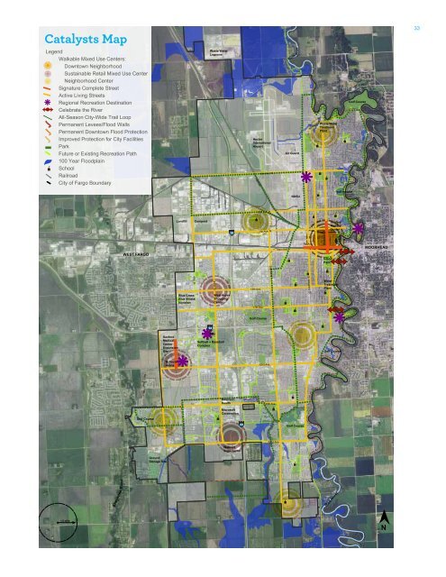
- Page 35: CHAPTER 3CatalystsThis chapter is a
- Page 39 and 40: ailroadiver35Waste WaterLagoonsNort
- Page 41 and 42: CATALYSTS | 3724th Avenue South244S
- Page 43 and 44: CATALYSTS | 39More energy efficient
- Page 45 and 46: ailroadiver41Waste WaterLagoonsNort
- Page 47 and 48: ailroadiver43Waste WaterLagoonsNort
- Page 49 and 50: LIVELIVELIVECATALYSTS | 45WORKWORKR
- Page 51 and 52: ailroadiver47Waste WaterLagoonsNort
- Page 53 and 54: ailroadiver49Waste WaterLagoonsNort
- Page 55 and 56: ailroadiver51Waste WaterLagoonsNort
- Page 57 and 58: CATALYSTS | 53Energy Efficiency and
- Page 59 and 60: Chapter 4Water and EnvironmentFargo
- Page 61 and 62: WATER AND ENVIRONMENT | 57Initiativ
- Page 63 and 64: After: Stormwater management for en
- Page 65 and 66: WATER AND ENVIRONMENT | 61for sandb
- Page 67 and 68: WATER AND ENVIRONMENT | 63
- Page 69 and 70: WATER AND ENVIRONMENT | 65BENEFITST
- Page 71 and 72: WATER AND ENVIRONMENT | 67This init
- Page 73 and 74: WATER AND ENVIRONMENT | 69case stud
- Page 75 and 76: WATER AND ENVIRONMENT | 71and parti
- Page 77 and 78: WATER AND ENVIRONMENT | 73in the gr
- Page 79 and 80: WATER AND ENVIRONMENT | 75case stud
- Page 81 and 82: WATER AND ENVIRONMENT | 77Urban are
- Page 83 and 84: WATER AND ENVIRONMENT | 79
- Page 85 and 86: WATER AND ENVIRONMENT | 81While cur
- Page 87 and 88:
WATER AND ENVIRONMENT | 83case stud
- Page 89 and 90:
WATER AND ENVIRONMENT | 85case stud
- Page 91 and 92:
WATER AND ENVIRONMENT | 87
- Page 93 and 94:
WATER AND ENVIRONMENT | 89vast amou
- Page 95 and 96:
WATER AND ENVIRONMENT | 91case stud
- Page 97:
WATER AND ENVIRONMENT | 93BENEFITSR
- Page 100 and 101:
EnergyEnergyFargo is a national lea
- Page 102 and 103:
EnergyInitiative 01Promote communit
- Page 104 and 105:
EnergySustainable Transportation an
- Page 106 and 107:
EnergyInitiative 02City led Energy
- Page 108 and 109:
EnergyThe planning team established
- Page 110 and 111:
EnergyNew BuildingsThe City should
- Page 112 and 113:
EnergyInitiative 03Smart GridCataly
- Page 114 and 115:
Energycase studyPowerCentsDC, Washi
- Page 117 and 118:
Chapter 6Arts and CultureFargo will
- Page 119 and 120:
Arts and Culture | 115Initiatives:0
- Page 121 and 122:
Arts and Culture | 117BENEFITSPubli
- Page 123 and 124:
Arts and Culture | 119case studySea
- Page 125 and 126:
Arts and Culture | 121Parks and pla
- Page 127 and 128:
Arts and Culture | 123case studyPla
- Page 129 and 130:
Arts and Culture | 125BENEFITSFesti
- Page 131 and 132:
Arts and Culture | 127case studyChe
- Page 133 and 134:
Arts and Culture | 129Additionally,
- Page 135 and 136:
Arts and Culture | 131
- Page 137:
Arts and Culture | 133BenefitsThe A
- Page 140 and 141:
HealthHealthResidents in Fargo gene
- Page 142 and 143:
HealthBefore: Underutilized spaceTh
- Page 144 and 145:
HealthInitiative 01City-Wide Trail
- Page 146 and 147:
Healthcase studiesSioux Falls, Sout
- Page 148 and 149:
Healthcase studiesDavis, California
- Page 150 and 151:
HealthInitiative 02Year-Round Recre
- Page 152 and 153:
Healthcase studyThe Depot RinkMinne
- Page 154 and 155:
HealthInitiative 03Healthy FoodReco
- Page 156 and 157:
Healthcase studyDane County Food Co
- Page 158 and 159:
HealthInitiative 04Access to Health
- Page 160 and 161:
Healthcase studyMayo ClinicRocheste
- Page 162 and 163:
HealthInitiative 05Regional Recreat
- Page 164 and 165:
“
- Page 166 and 167:
TransportationTransportationFargo h
- Page 168 and 169:
TransportationInitiative 01Bicycle
- Page 170 and 171:
Transportationcase studyBoulder, Co
- Page 172 and 173:
TransportationInitiative 02Complete
- Page 174 and 175:
TransportationInitiative 03Transit
- Page 176 and 177:
Transportationcase studyDes Moines
- Page 178 and 179:
TransportationInitiative 04Clear an
- Page 180 and 181:
Transportationcase studyDowntown Ba
- Page 182 and 183:
TransportationInitiative 05Transpor
- Page 184 and 185:
Transportationcase studyTower Road
- Page 186 and 187:
TransportationInitiative 06Intellig
- Page 188 and 189:
TransportationInitiative 07Parkingr
- Page 191 and 192:
Chapter 9EconomyFargo will build on
- Page 193 and 194:
ECONOMY | 189Initiatives:01: Amenit
- Page 195 and 196:
After: Public Realm Improvements ca
- Page 197 and 198:
ECONOMY | 193BENEFITSInvesting in a
- Page 199 and 200:
ECONOMY | 195with an average salary
- Page 201 and 202:
ECONOMY | 197case studyCoCo - Cowor
- Page 203 and 204:
ECONOMY | 199Large surfaceparking l
- Page 205 and 206:
ECONOMY | 201CommercialResidentialP
- Page 207 and 208:
ECONOMY | 203Associates degrees and
- Page 209 and 210:
ECONOMY | 205case studyWisconsin De
- Page 211 and 212:
ECONOMY | 207Coordination with Nort
- Page 213:
ECONOMY | 209BENEFITSPublic/Private
- Page 216 and 217:
Neighborhoods, Infill, and New Deve
- Page 218 and 219:
Strategies for a new pattern of dev
- Page 220 and 221:
Neighborhoods, Infill, and New Deve
- Page 222 and 223:
Neighborhoods, Infill, and New Deve
- Page 224 and 225:
Neighborhoods, Infill, and New Deve
- Page 226 and 227:
Neighborhoods, Infill, and New Deve
- Page 228 and 229:
Neighborhoods, Infill, and New Deve
- Page 230 and 231:
Neighborhoods, Infill, and New Deve
- Page 232 and 233:
Neighborhoods, Infill, and New Deve
- Page 234 and 235:
Neighborhoods, Infill, and New Deve
- Page 236 and 237:
Neighborhoods, Infill, and New Deve
- Page 238 and 239:
Neighborhoods, Infill, and New Deve
- Page 240 and 241:
Neighborhoods, Infill, and New Deve
- Page 242 and 243:
Neighborhoods, Infill, and New Deve
- Page 245 and 246:
Chapter 11EducationFargo will uphol
- Page 247 and 248:
Education | 243Initiatives:Fargo is
- Page 249 and 250:
Education | 245not safe. Many feel
- Page 251 and 252:
Education | 247Unfortunately, enrol
- Page 253 and 254:
Education | 249the structure from t
- Page 255:
Education | 251Initiative 05Support
- Page 258 and 259:
SafetySafetyFargo, like all municip
- Page 260 and 261:
SafetyInitiative 01Crime Prevention
- Page 262 and 263:
SafetyInitiative 02Disaster and Eme
- Page 264 and 265:
Creative Commons Photo Credits Pg.
- Page 268:
BNIM + SRF + AE2S